
Onondaga County is a county in the U.S. state of New York. As of the 2020 census, the population was 476,516. The county seat is Syracuse. The county is part of the Central New York region of the state.

Niles is a town in Cayuga County, New York, United States. The population was 1,194 at the 2010 census. Niles lies in the eastern part of the county, southeast of Auburn.

Sempronius is a town in Cayuga County, New York, United States. The population was 895 at the 2010 census. The town was named after a Roman military and political leader by Robert Harpur, a clerk interested in the classics. Sempronius is in the southeastern part of the county, southeast of Auburn.

Spafford is a town in Onondaga County, New York, United States. As of the 2020 Census, the population was 1,588. The town was named after Horatio Gates Spafford, a writer and founder of the local library. Spafford is in the southwestern corner of Onondaga County and is southwest of Syracuse.

Elbridge is a town in Onondaga County, New York, United States. As of the 2020 Census, the population was 5,476. The town is named after Elbridge Gerry, the fifth Vice President of the United States, and one of the signers of the Declaration of Independence.
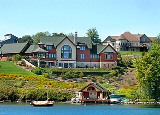
Skaneateles is a town in Onondaga County, New York, United States. As of the 2020 Census, the population was 7,112. The name is from the Iroquois term for the adjacent Skaneateles Lake, which means "long lake." The town is on the western border of the county and includes a village, also named Skaneateles. Both the town and village are southwest of Syracuse.

Skaneateles Lake is one of the Finger Lakes in central New York in the United States. The name Skaneateles means long lake in one of the local Iroquoian languages. The lake is sometimes referred to as "The Roof Garden of the Lakes" because its altitude is higher than the other Finger Lakes. It is one of the cleanest lakes in the United States.

Area codes 315 and 680 are telephone area codes of the North American Numbering Plan (NANP) for the north-central area of the U.S. state of New York. Area code 315 was installed as one of the original North American area codes in 1947, while area code 680 was added to the numbering plan area (NPA) in an overlay plan in 2017.
Skaneateles may refer to, in the United States:
Shepard Settlement was a farming hamlet in the northeastern part of the Town of Skaneateles in Onondaga County, New York, United States.

Sycamore is an unincorporated community in eastern Ozark County in the Ozarks of southern Missouri, United States. It is located on Route 181, approximately fourteen miles northeast of Gainesville. The old townsite is located on a ridge on the west side of Bryant Creek, a major tributary of the North Fork River. The old Hodgson Mill and spring lie on Bryant Creek 0.8 mi (1.3 km) to the northeast. The mill was nominated to the National Register of Historic Places as Aid-Hodgson Mill in 2001.

New York State Route 41A (NY 41A) is a north–south state highway in Central New York in the United States. It extends for 25.49 miles (41.02 km) from an intersection with NY 41 in the Cortland County town of Homer to a junction with U.S. Route 20 (US 20) in the Onondaga County village of Skaneateles. The southern half of NY 41A serves mostly rural areas, while the route's northern half runs along the western edge of Skaneateles Lake. NY 41A was assigned as part of the 1930 renumbering of state highways in New York to several previously unnumbered state roads and a section of pre-1930 NY 26.

Mulino, Oregon is a hamlet and census-designated place (CDP) located in Clackamas County, Oregon, United States, on Oregon Route 213 between the cities of Oregon City and Molalla. As of the 2010 census it had a population of 2,103.
Borodino is a hamlet located at the intersection of New York State Route 41 and New York State Route 174 in the Town of Spafford in Onondaga County, New York, United States, near Skaneateles Lake. The hamlet proper extends five to ten properties to the east, south, west and north from the intersection, until houses and a few other buildings are replaced by farm fields. A monument for veterans, designed by Gianfranco Fritelli, stands in a cemetery at the southeast corner of the intersection. A little-altered Federal style Methodist Church, known locally as "The Church", dating from 1830, stands close to the 174, about five properties north. The Borodino District School No. 8 and Borodino Hall (1835) are listed on the National Register of Historic Places.
Skaneateles Community was a utopian social experiment established in 1843 by the Society for Universal Inquiry and Reform in a 350-acre (1.4 km2) farm near Mottville, in Skaneateles in Upstate New York based on Fourierist principles. It was one of several communities established by the Society prior to the Civil War.
Jonas Earll Jr. was an American politician. He was a U.S. Representative from New York from 1827 to 1831.
Nehemiah Hezekiah Earll was a 19th-century American lawyer and politician who served one term as a U.S. Representative from New York from 1839 to 1841.
Skaneateles Creek is a river in New York, the United States. It drains Skaneateles Lake to the Seneca River. It flows through Skaneateles, Skaneateles Falls, Mottville, Elbridge, and Jordan before joining the Seneca River, about 2 miles northwest of Jordan, New York.
Lamoureux is a hamlet in central Alberta, Canada within Sturgeon County. It is located 6 kilometres (3.7 mi) northeast of Edmonton's city limits on the northern shore of the North Saskatchewan River, on the opposite side of the City of Fort Saskatchewan. The location has a view of the ruins of the old Fort, which can still be seen standing by the riverfront.

