Memphis, New York

Last updated

Memphis, New York
USA New York location map.svg
Red pog.svg
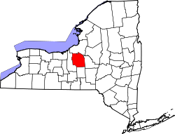
Memphis, New York
Location within the state of New York
Coordinates: 43°5′12″N76°22′40″W / 43.08667°N 76.37778°W / 43.08667; -76.37778
Country United States
State New York
County Onondaga
Time zone UTC-5 (Eastern (EST))
  Summer (DST) UTC-4 (EDT)
ZIP code
13112 [1]
Area code(s) 315 and 680
Map of Memphis from Sweet's 1874 Atlas of Onondaga County, N.Y. Memphis NY 1874 Sweet's Atlas map.png
Map of Memphis from Sweet's 1874 Atlas of Onondaga County, N.Y.

Memphis is a hamlet in the Town of Van Buren, west of Syracuse in Onondaga County, New York, United States.

Because of its location on the southern town line of Van Buren, above the Towns of Elbridge and Camillus, the Memphis area can also be considered to extend into Elbridge and Camillus. A section of Memphis lies on Cross Lake and Seneca River.

In the early 1800s, the hamlet was named "Canton". Sometime after the 1850s, the name was changed to the current "Memphis", presumably because Canton was already established. Now the name "Canton" refers to a small community between Memphis and Camillus.

From 1825 to 1918, The Erie Canal ran through the north side of Memphis. The First Baptist Church of Memphis was also located in Memphis from 1815 to 2013.The Plainville Turkey Farm used to be in Memphis, which included a restaurant, which closed in February 2010.

The small community is spread over a wide area due to the primary use of land for farming. Well known farms include a portion of Hourigan's Farms, the Hooper Farm, and a portion of Blumer's Farms. There is also an area known by locals as "The Kingdom," named for Kingdom Road. The road follows the east side of the Seneca River, traveling from Jack's Reef to State Route 31.

Directly north of Memphis, past the hamlet of Ionia, lies a small unmarked community. Formerly called Sand Springs in the 1800s, the area is now more commonly known as Whisky Hollow. It is home to the Whiskey Hollow Nature Preserve, a rough road bridging Perry Road to West Dead Creek Road. The preserve has been relatively untouched in the past century. Within the preserve lies a natural spring, which the local community uses as a fresh source of water.

Related Research Articles

<span class="mw-page-title-main">Collins, New York</span> Town in New York, United States

Collins is a town in Erie County, New York, United States. The town is on the south border of the county and is considered to be one of the "Southtowns" of Erie County. The population at the 2010 census was 6,601.

<span class="mw-page-title-main">Alabama, New York</span> Town in New York, United States

Alabama is a town in Genesee County, New York, United States. The town is in the northwestern part of the county. New York State Routes 63 and 77 intersect in the town. The population was 1,869 at the 2010 census. The town is named after the state of Alabama.

<span class="mw-page-title-main">Lysander, New York</span> Town in New York, United States

Lysander is a town in Onondaga County, New York, United States. As of the 2020 Census, the population was 23,074. The town was named after Lysander, a Spartan military leader, by a clerk interested in the classics. Lying to the northwest of Syracuse, much of the town is suburban in character.

<span class="mw-page-title-main">Van Buren, New York</span> Town in New York, United States

Van Buren is a town located in Onondaga County, New York, United States. As of the 2020 Census, the population was 14,367. The town is named after then-Senator Martin Van Buren, who would later become the eighth president of the United States.

<span class="mw-page-title-main">Camillus, New York</span> Town in New York, United States

Camillus is a town in Onondaga County, New York, United States. As of the 2020 Census, the population was 25,346.

<span class="mw-page-title-main">Elbridge, New York</span> Town in New York, United States

Elbridge is a town in Onondaga County, New York, United States. As of the 2020 Census, the population was 5,476. The town is named after Elbridge Gerry, the fifth Vice President of the United States, and one of the signers of the Declaration of Independence.

<span class="mw-page-title-main">New York State Route 5</span> State highway in New York, US

New York State Route 5 (NY 5) is a state highway that extends for 370.80 miles (596.74 km) across the state of New York in the United States. It begins at the Pennsylvania state line in the Chautauqua County town of Ripley and passes through Buffalo, Syracuse, Utica, Schenectady, and several other smaller cities and communities on its way to downtown Albany in Albany County, where it terminates at U.S. Route 9 (US 9), here routed along the service roads for Interstate 787 (I-787). Prior to the construction of the New York State Thruway, it was one of two main east–west highways traversing upstate New York, the other being US 20. West of New York, the road continues as Pennsylvania Route 5 (PA 5) to Erie.

<span class="mw-page-title-main">Area codes 315 and 680</span> Area codes in New York (state)

Area codes 315 and 680 are telephone area codes of the North American Numbering Plan (NANP) for the north-central area of the U.S. state of New York. Area code 315 was installed as one of the original North American area codes in 1947, while area code 680 was added to the numbering plan area (NPA) in an overlay plan in 2017.

<span class="mw-page-title-main">New York State Route 48</span> State highway in Central New York, US

New York State Route 48 (NY 48) is a 28.20-mile (45.38 km) north–south state highway in Central New York in the United States. The southern terminus of the route is located at Interstate 690 (I-690) exit 3 near the interchange between I-690 and the New York State Thruway (I-90) in Van Buren, northwest of Syracuse. The northern terminus is located at an intersection with NY 104 in Oswego. In between, NY 48 passes through the riverside communities of Baldwinsville and Fulton and runs alongside both the Seneca River and Oswego River. For most of its route, NY 48 serves as an alternate route of NY 481. The routes share similar alignments along the Oswego River from the Syracuse area to Oswego, with NY 481 following the eastern riverbank between the two locations.

Honeoye is a hamlet in the Town of Richmond, in Ontario County, New York, United States. The population was 579 at the 2010 census, which lists the community as a census-designated place (CDP).

Guilderland Center is a hamlet in the town of Guilderland, Albany County, New York, United States. The hamlet lies along New York Route 146 and the Black Creek, a tributary of the Normans Kill.

<span class="mw-page-title-main">New York State Route 173</span> State highway in central New York, US

New York State Route 173 (NY 173) is a state highway located in the Syracuse area of central New York in the United States. It takes a slightly bow-shaped route from NY 31 in the town of Van Buren to NY 5 in Chittenango, gently curving to the south of Downtown Syracuse in the center of its 30.59-mile (49.23 km) routing. Even so, NY 173 briefly enters the Syracuse city limits near where it intersects U.S. Route 11 (US 11). NY 173 passes through several suburbs of Syracuse, including Camillus, where it first meets NY 5, and Manlius, where it has a short overlap with NY 92.

<span class="mw-page-title-main">New York State Route 174</span> State highway in Onondaga County, New York, US

New York State Route 174 (NY 174) is a state highway in Onondaga County, located in Central New York, in the United States. The highway is 16.7 miles (26.9 km) long and passes through mostly rural regions. Route 174 begins at an intersection with NY 41 in Borodino, a hamlet of Spafford. It heads generally northward for most of its length, except for short distances in the villages of Marcellus and Camillus. The route ends at a junction with NY 5 west of Camillus, at the west end of the Route 5 Camillus bypass. Route 174 is located along a large mapped sedimentary bedrock unit, known as the Marcellus Formation. The formation is named for an outcrop found near the town of Marcellus, New York, during a geological survey in 1839.

<span class="mw-page-title-main">New York State Route 321</span> State highway in Onondaga County, New York, US

New York State Route 321 (NY 321) is a 8.45-mile-long (13.60 km) state highway in Onondaga County, New York, in the United States. The southern terminus of the route is at an intersection with U.S. Route 20 (US 20) in the village of Skaneateles. Its northern terminus is at an intersection with NY 5 in Bennetts Corners, a hamlet within the town of Camillus. NY 321 is predominantly a north–south highway; however, a portion of the route through the towns of Elbridge and Camillus follows an east–west alignment. The portion of NY 321 in Camillus between Forward Road and NY 5 is maintained by Onondaga County as part of County Route 66 (CR 66), a route that continues north of NY 5 to Memphis.

<span class="mw-page-title-main">New York State Route 20SY</span> Former highway in New York

New York State Route 20SY (NY 20SY) was a state highway in the vicinity of the city of Syracuse, New York, in the United States. It connected U.S. Route 20 (US 20) to downtown Syracuse via Skaneateles, Camillus, Manlius, and Cazenovia in Onondaga County and Madison County. The highway began at an intersection with US 20 and NY 321 in the village of Skaneateles and ended at a junction with US 20, NY 20N, and NY 92 near the village of Cazenovia. Most of NY 20SY overlapped another route; however, two sections of NY 20SY—one in the town of Camillus and another near the village of Fayetteville—were not concurrent with another highway.

<span class="mw-page-title-main">Trapps Mountain Hamlet Historic District</span> Historic district in New York, United States

The Trapps Mountain Hamlet Historic District is located on the Shawangunk Ridge in Gardiner, New York, United States. It is a large area that covers the site of a settlement that thrived there from the late 18th to mid-20th centuries. Inhabitants practiced subsistence farming, making it one of the rare such communities in the East to have left any trace remaining. They supplemented that with a variety of other trades, primarily in the forest products industry, with most inhabitants gradually coming to work at nearby mountain resorts in the 20th century. The last resident died in 1956.

Flint Creek is a creek in the Finger Lakes region of New York State, located between Canandaigua Lake and Seneca Lake. Flint Creek is part of the Canandaigua Lake watershed which is part of the Oswego River drainage basin, which ultimately drains to Lake Ontario. It has two head springs in the town of Italy which come together on the floor of Italy Valley. It then flows through the hamlets of Potter, Gorham, and Seneca Castle, and ends in the village of Phelps where it joins the Canandaigua Outlet.

<span class="mw-page-title-main">Pocantico River</span> River in the United States of America

The Pocantico River is a nine-mile-long (14 km) tributary of the Hudson River in western central Westchester County, New York, United States. It rises from Echo Lake, in the town of New Castle south of the hamlet of Millwood, and flows generally southwest past Briarcliff Manor to its outlet at Sleepy Hollow. Portions of the towns of Mount Pleasant and Ossining are within its 16-square-mile (41 km2) watershed.

Elko was a town in Cattaraugus County, New York that existed from 1890 to 1965. It was forcibly evacuated in 1965 due to the construction of the Kinzua Dam on the Allegheny River in Warren County, Pennsylvania, one of the largest dams in the United States east of the Mississippi. The dam was authorized by the United States Congress as a flood control measure in the Flood Control Acts of 1936 and 1938, and was built by the U. S. Army Corps of Engineers beginning in 1960. Other benefits from the dam include drought control, hydroelectric power production, and recreation.

First Baptist Church of Memphis, NY, is a Baptist Church located at 1960 West Genesee Turnpike in the town of Camillus, NY with an Elbridge postal address.

References

  1. "Memphis ZIP Code". zipdatamaps.com. 2022. Retrieved November 11, 2022.