Shepard Settlement, New York

Last updated
Shepard Settlement
hamlet
USA New York location map.svg
Red pog.svg
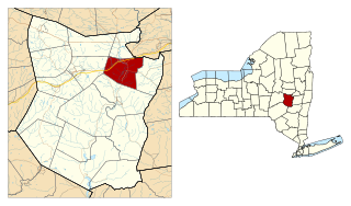
Shepard Settlement
Location within the state of New York
Coordinates: 42°59′43″N76°23′00″W / 42.99528°N 76.38333°W / 42.99528; -76.38333 Coordinates: 42°59′43″N76°23′00″W / 42.99528°N 76.38333°W / 42.99528; -76.38333
Country United States
State New York
County Onondaga
Time zone Eastern (EST) (UTC-5)
  Summer (DST) EDT (UTC-4)

Shepard Settlement was a farming hamlet in the northeastern part of the Town of Skaneateles in Onondaga County, New York.

Skaneateles (town), New York Town in New York, United States

Skaneateles is a town in Onondaga County, New York, United States. The population was 7,209 at the 2010 census. The name is from the Iroquois term for the adjacent Skaneateles Lake, which means "long lake." The town is on the western border of the county and includes a village, also named Skaneateles. Both town and village are southwest of Syracuse.

Onondaga County, New York county in New York, United States

Onondaga County is a county in the U.S. state of New York. As of the 2010 census, the population was 467,026. The county seat is Syracuse.

Named for the first settlers, this was the second community founded in the Town of Skaneatles, after the Village of Skaneatles at the northern end of Skaneateles Lake. Other early settler families with numerous members in the immediate area include the Chapmans, Bishops, Horsingtons and Hares. The settlement was along Stump Road between Hoyt and Foster Roads on the west and Shepard Road on the east, centered roughly where Chapman Road ends at Stump Road. The hamlet was 2.6 miles WNW of the Village of Marcellus and 4 miles NE of Skaneateles.

Skaneateles Lake lake

Skaneateles Lake is one of the Finger Lakes in central New York in the United States. The name Skaneateles means long lake in one of the local Iroquoian languages. The lake is sometimes referred to as "The Roof Garden of the Lakes" because its altitude is higher than the other Finger Lakes.

Marcellus (village), New York Village in New York, United States

Marcellus is a village located in the town of Marcellus in Onondaga County, New York, United States. The population was 1,813 at the 2010 census. The village is southwest of Syracuse and is in the southern part of the town of Marcellus.

The various amenities of a rural community, such as a church and general store, have long since disappeared, leaving only Shepard Settlement Cemetery on the northwestern corner of Stump and Foster Roads to establish the community's identity.

The Shepard Settlement Cemetery was listed on the National Register of Historic Places in 2010. [1]

Shepard Settlement Cemetery

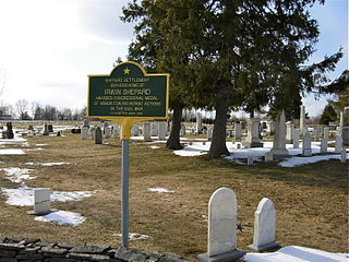
Shepard Settlement Cemetery is a historic cemetery located at Shepard Settlement, Onondaga County, New York. It was established about 1823, and remains an active burial ground containing approximately 500 burials. It is notable for including the graves of at least 30 veterans of all wars from the Revolutionary War to World War II. The gravestones are representative of typical funerary art of the mid-19th century.

National Register of Historic Places federal list of historic sites in the United States

The National Register of Historic Places (NRHP) is the United States federal government's official list of districts, sites, buildings, structures, and objects deemed worthy of preservation for their historical significance. A property listed in the National Register, or located within a National Register Historic District, may qualify for tax incentives derived from the total value of expenses incurred preserving the property.

Related Research Articles

Chautauqua, New York Town in New York, United States

Chautauqua is a town and lake resort community in Chautauqua County, New York, United States. The population was 4,464 at the 2010 census. The town is named after Chautauqua Lake. The traditional meaning remains "bag tied in the middle". The suggested meanings of this Seneca word have become numerous: "the place where one is lost"; "the place of easy death"; "fish taken out"; "foggy place"; "high up"; "two moccasins fastened together"; and "a bag tied in the middle".

Scott, New York Town in New York, United States

Scott is a town in Cortland County, New York, United States. The population was 1,176 at the 2010 census. The town was named after General Winfield Scott. It is in the northwest corner of Cortland County and is northwest of Cortland.

Durham, New York Town in New York, United States

Durham is a town in Greene County, New York, United States. The population was 2,725 at the 2010 census. The town was named after Durham, Connecticut, and is in the northwest corner of Greene County.

Clifton Park, New York Town in New York, United States

Clifton Park is a suburban town in Saratoga County, New York, United States. According to the United States Census Bureau, the 2010 population was 36,705. The name is derived from an early land patent. The town is in the south part of the county and is located approximately 12 miles (19 km) north of Albany, 7 miles (11 km) northeast of Schenectady, and 10 miles (16 km) south of Saratoga Springs.

Edinburg, New York Town in New York, United States

Edinburg is a town in Saratoga County, New York, United States. The population was 1,384 at the 2000 census. The town is named after the city of Edinburgh in Scotland.

Malta, New York Town in New York, United States

Malta is a town in Saratoga County, New York, United States. The town is in the central part of the county and is south of Saratoga Springs. The population was 14,765 as of the 2010 census.

Jefferson, New York Town in New York, United States

Jefferson is a town in Schoharie County, New York, USA. The population was 1,285 at the 2000 census.

Mamakating, New York Town in New York, United States

Mamakating is a town in Sullivan County, New York, United States. The population was 12,085 at the 2010 census.

Chatham (town), New York Town in New York, United States

Chatham is a town in Columbia County, New York, United States. The population was 4,128 at the 2010 census.

Frankfort (town), New York Town in New York, United States

Frankfort is a town in Herkimer County, New York, United States. The town is named after one of its earliest settlers, Lawrence (Lewis) Frank. The town of Frankfort includes a village, also called Frankfort. Frankfort is located east of Utica, and the Erie Canal passes along its north border. At the time of the 2010 census, the population was 7,636.

Skaneateles (village), New York Village in New York, United States

Skaneateles is an affluent village in the town of Skaneateles, Onondaga County, New York, United States. The village is named from and located on the shores of Skaneateles Lake, one of the Finger Lakes. As of the 2010 census, the village had a population of 2,450 residents.

Schoharie, New York Town in New York, United States

Schoharie is a town in Schoharie County, New York. The population was 3,299 at the 2000 census.

Newark Valley is a town in Tioga County, New York, United States. The population was 3,946 at the 2010 census. The town is named after the city of Newark, New Jersey.

Owego is a town in Tioga County, New York, United States. The population was 19,883 at the 2010 census. The name is derived from the Iroquois word Ahwaga, meaning where the valley widens.

Salem (hamlet), New York Hamlet and CDP in New York, United States

Salem is a hamlet located in the town of Salem in Washington County, New York, United States. It is part of the Glens Falls Metropolitan Statistical Area. The population was 946 at the 2010 census.

New York State Route 175 (NY 175) is a west–east state highway located in Onondaga County, New York, in the United States. The 15.46-mile (24.88 km) route begins at an intersection with U.S. Route 20 (US 20) east of the village of Skaneateles and passes through the village of Marcellus before ending at a junction with US 11 in Syracuse. The highway was designated in the 1930 renumbering of state highways in New York.

Borodino, New York hamlet in New York, United States

Borodino is a hamlet located at the intersection of New York State Route 41 and New York State Route 174 in the Town of Spafford in Onondaga County, New York, near Skaneateles Lake. The hamlet proper extends five to ten properties to the east, south, west and north from the intersection, until houses and a few other buildings are replaced by farm fields. A monument for veterans, designed by Gianfranco Fritelli, stands in a cemetery at the southeast corner of the intersection. A little-altered Federal style Methodist Church, known locally as "The Church", dating from 1830, stands close to the 174, about five properties north. The Borodino District School No. 8 and Borodino Hall (1835) are listed on the National Register of Historic Places.

Hurley Historic District

The Hurley Historic District encompasses the center of the hamlet of Hurley, the main settlement area of the town of Hurley, New York. Stretched along US 209, the hamlet includes one of the finest concentrations of colonial Dutch architecture in the United States. Settled by the Dutch in the 17th century, its architecture has retained the influence of that period. The village is also historically significant as a temporary home of the seat of New York government during the American Revolutionary War. It was designated a National Historic Landmark in 1961.

East Derry, New Hampshire Unincorporated community in New Hampshire, United States

East Derry, also known as the Upper Village, is an unincorporated community in the town of Derry in Rockingham County, New Hampshire. The village center constitutes the East Derry Historic District, listed on the National Register of Historic Places. It is located on a hill close to the geographic center of the town of Derry along East Derry Road, approximately 2 miles (3 km) east of the built-up town center of Derry. East Derry has a separate ZIP code (03041) from the rest of the town of Derry. Alan Shepard lived in the village as a boy. Station #4 of the Derry Fire Department is located in the village.

References

  1. "National Register of Historic Places". Weekly List of Actions Taken on Properties: 11/29/10 through 12/03/10. National Park Service. 2010-12-10.