
Onondaga County is a county in the U.S. state of New York. As of the 2020 census, the population was 476,516. The county seat is Syracuse.

Cicero is a town in northern Onondaga County, New York, United States. The population was 31,632 at the 2010 census. The name of the town was assigned by a clerk interested in the classics, honoring Cicero, a Roman statesman.

Lysander is a town in Onondaga County, New York, United States. The population was 21,759 at the 2010 census. The town was named after Lysander, a Spartan military leader, by a clerk interested in the classics. The town is in the northwestern corner of Onondaga County and is located northwest of Syracuse. Much of the town is a suburb of Syracuse.

Onondaga is a town in Onondaga County, New York, United States encompassing 65 square miles. As of the 2020 U.S. Census, the town had a population of 22,937. The town is named after the native Onondaga tribe, part of the Iroquois Confederacy. Onondaga was incorporated April 2, 1798 and is located southwest of the city of Syracuse, which it borders. The villages and hamlets which make up the town are: Cedarvale, Howlett Hill, Navarino, Nedrow, Onondaga Hill, Sentinel Heights, South Onondaga, Southwood, Split Rock, and Taunton.
Pompey is a town in the southeast part of Onondaga County, New York. The population was 7,080 at the time of the 2010 census. The town was named after the Roman general and political leader Pompey by a late 18th-century clerk interested in the Classics in the new federal republic.

Salina is a town in Onondaga County, New York, United States. The population was 33,710 at the 2010 census. The name of the town is derived from the Latin word for "salt". Salina is a northwestern suburb of the city of Syracuse.

Camillus is a town in Onondaga County, New York, United States. The population was 24,167 at the 2010 census.

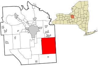
Manlius is a town in Onondaga County, east of the city of Syracuse, New York, United States. The population was 33,712 at the 2020 census, making it the third largest suburb in metropolitan Syracuse. In 2005, the town was ranked 98th on CNN's list of Best Places to Live.

Marcellus is a village in the town of Marcellus in Onondaga County, New York, United States. The population was 1,813 at the 2010 census. The village is southwest of Syracuse and is in the southern part of the town of Marcellus.

Marcellus is a town in Onondaga County, New York, United States. The population was 6,210 at the 2010 census. The town was probably named after Marcus Claudius Marcellus, a Roman general, by a clerk interested in the Classics.

New York State Route 48 (NY 48) is a 28.20-mile (45.38 km) north–south state highway in Central New York in the United States. The southern terminus of the route is located at Interstate 690 (I-690) exit 3 near the interchange between I-690 and the New York State Thruway (I-90) in Van Buren, northwest of Syracuse. The northern terminus is located at an intersection with NY 104 in Oswego. In between, NY 48 passes through the riverside communities of Baldwinsville and Fulton and runs alongside both the Seneca River and Oswego River. For most of its route, NY 48 serves as an alternate route of NY 481. The routes share similar alignments along the Oswego River from the Syracuse area to Oswego, with NY 481 following the eastern riverbank between the two locations.
Southside is one of the 26 official neighborhoods in Syracuse, New York.

New York State Route 173 (NY 173) is a state highway located in the Syracuse area of central New York in the United States. It takes a slightly bow-shaped route from NY 31 in the town of Van Buren to NY 5 in Chittenango, gently curving to the south of Downtown Syracuse in the center of its 30.59-mile (49.23 km) routing. Even so, NY 173 briefly enters the Syracuse city limits near where it intersects U.S. Route 11 (US 11). NY 173 passes through several suburbs of Syracuse, including Camillus, where it first meets NY 5, and Manlius, where it has a short overlap with NY 92.

New York State Route 175 is an east–west state highway located entirely within Onondaga County, New York, in the United States. The 15.46-mile (24.88 km) route begins at an intersection with U.S. Route 20 (US 20) east of the village of Skaneateles and passes through the village of Marcellus before ending at a junction with US 11 in Syracuse. The highway was designated in the 1930 renumbering of state highways in New York.

New York State Route 370 (NY 370) is an east–west state highway in Central New York in the United States. It extends for about 35 miles (56.33 km) from an intersection with NY 104 and NY 104A south of the Wayne County village of Red Creek to a junction with U.S. Route 11 (US 11) in the Onondaga County city of Syracuse. The western and central portions of the route pass through mostly rural areas; however, the eastern section serves densely populated areas of Onondaga County, including the villages of Baldwinsville and Liverpool. NY 370 also passes through Cayuga County, where it connects to NY 34, a major north–south highway in Central New York.
Borodino is a hamlet located at the intersection of New York State Route 41 and New York State Route 174 in the Town of Spafford in Onondaga County, New York, United States, near Skaneateles Lake. The hamlet proper extends five to ten properties to the east, south, west and north from the intersection, until houses and a few other buildings are replaced by farm fields. A monument for veterans, designed by Gianfranco Fritelli, stands in a cemetery at the southeast corner of the intersection. A little-altered Federal style Methodist Church, known locally as "The Church", dating from 1830, stands close to the 174, about five properties north. The Borodino District School No. 8 and Borodino Hall (1835) are listed on the National Register of Historic Places.

New York State Route 57 (NY 57) was a north–south state highway in the central portion of New York in the United States. It extended for 33.45 miles (53.83 km) from an intersection with U.S. Route 11 (US 11) just north of downtown Syracuse to a junction with NY 104 six blocks from the Lake Ontario shoreline in Oswego. North of Liverpool, NY 57 was routed along the eastern bank of the Seneca and Oswego Rivers. It passed through several riverside communities, including the village of Phoenix and the city of Fulton. The route largely paralleled NY 48, which follows the western bank of the waterway between Van Buren and Oswego via Baldwinsville.

Whig Hill is a historic home located near Plainville, Onondaga County, New York. The main house was built in 1833, and is a 2+1⁄2-story, five-bay, Greek Revival-style brick dwelling with a nearly flat roof. Whig Hill was the principal element within a listing Whig Hill and Dependencies, which included two barn clusters, a tenant house, and other outbuildings. The barn cluster north of Genesee Street, described in 1975, is no longer present, in 2009. The south barn remains.
James L. Voorhees was an American farmer, lumberman, and politician from New York.
Architecture Worth Saving in Onondaga County is a 1964 book that surveyed buildings across Onondaga County, New York, and discussed their historical value. Undertaken by the New York State Council on the Arts, and compiled by a group of professors at the Syracuse University School of Architecture, the book was initially well received by historians and architects who hoped the book would be the first of several. However, it had gone out of print by 1975, and many of the buildings listed had been destroyed.

