Minoa, New York

Last updated

Minoa, New York
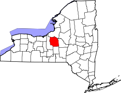
Onondaga County New York incorporated and unincorporated areas Minoa highlighted.svg
Location in Onondaga County and the state of New York.
Coordinates: 43°4′37″N76°0′25″W / 43.07694°N 76.00694°W / 43.07694; -76.00694
Country United States
State New York
County Onondaga
Area
[1]
  Total1.32 sq mi (3.42 km2)
  Land1.32 sq mi (3.42 km2)
  Water0.00 sq mi (0.00 km2)
Elevation
413 ft (126 m)
Population
 (2020)
  Total3,657
  Density2,768.36/sq mi (1,068.92/km2)
Time zone UTC-5 (Eastern (EST))
  Summer (DST) UTC-4 (EDT)
ZIP code
13116
Area code 315
FIPS code 36-47757
GNIS feature ID0957426
Website www.villageofminoa.com

Minoa is a village in Onondaga County, New York, United States. As of the 2020 census, the population was 3,657. Minoa is in the northern part of the town of Manlius and is east of Syracuse.

Contents

History

Minoa is in the former Central New York Military Tract. It was known as "Manlius Station", a stop on the Syracuse and Utica Railroad (completed in 1839), until the name was changed to Minoa in 1895. [2]

The village was incorporated in 1913 and was once a prominent railroad community. The village is located on the eastern end of what was once the largest railroad yard New York Central Railroad in the world.

Notable people

Geography

Minoa is located at 43°4′37″N76°0′25″W / 43.07694°N 76.00694°W / 43.07694; -76.00694 (43.077067, -76.006955). [3]

According to the United States Census Bureau, the village has a total area of 1.2 square miles (3.1 km2), all land.

Demographics

Historical population
CensusPop.Note
1920 867
1930 8993.7%
1940 9020.3%
1950 1,00811.8%
1960 1,83882.3%
1970 2,24522.1%
1980 3,64062.1%
1990 3,7452.9%
2000 3,348−10.6%
2010 3,4493.0%
2020 3,6576.0%
U.S. Decennial Census [4]

As of the census [5] of 2000, there were 3,348 people, 1,249 households, and 940 families residing in the village. The population density was 2,700.3 inhabitants per square mile (1,042.6/km2). There were 1,293 housing units at an average density of 1,042.8 per square mile (402.6/km2). The racial makeup of the village was 96.62% White, 0.51% African American, 0.42% Native American, 1.43% Asian, 0.03% Pacific Islander, 0.21% from other races, and 0.78% from two or more races. Hispanic or Latino of any race were 0.57% of the population.

There were 1,249 households, out of which 38.4% had children under the age of 18 living with them, 58.1% were married couples living together, 13.5% had a female householder with no husband present, and 24.7% were non-families. 20.7% of all households were made up of individuals, and 9.3% had someone living alone who was 65 years of age or older. The average household size was 2.62 and the average family size was 3.03.

In the village, the population was spread out, with 26.1% under the age of 18, 7.0% from 18 to 24, 28.0% from 25 to 44, 25.1% from 45 to 64, and 13.8% who were 65 years of age or older. The median age was 39 years. For every 100 females, there were 88.6 males. For every 100 females age 18 and over, there were 83.9 males.

The median income for a household in the village was $49,100, and the median income for a family was $57,200. Males had a median income of $38,235 versus $28,689 for females. The per capita income for the village was $19,591. About 2.1% of families and 2.0% of the population were below the poverty line, including 1.3% of those under age 18 and 2.8% of those age 65 or over.

Government

The mayor is William F. Brazill and the deputy mayor is John H. Champagne. The trustees are John Abbott, Eric Christensen, and Robert Schepp.

Related Research Articles

Adams Center is a hamlet and census-designated place (CDP) in the town of Adams in Jefferson County, New York, United States. The population was 1,492 during the 2020 decennial census.

<span class="mw-page-title-main">DeWitt, New York</span> Town in New York, United States

DeWitt is a town in Onondaga County, New York, United States. As of the 2020 census, the population was 26,074. The town is named after major Moses DeWitt, a judge and soldier. An eastern suburb of Syracuse, DeWitt also is the site of most of the campus and all of the academic buildings of Le Moyne College.

<span class="mw-page-title-main">East Syracuse, New York</span> Village in New York, United States

East Syracuse is an incorporated village and a suburb of the City of Syracuse in eastern Onondaga County, New York, United States. As of the 2020 census, the population was 3,078. It is located immediately east of Syracuse, in the town of DeWitt.

<span class="mw-page-title-main">Fairmount, New York</span> Census-designated place in New York, United States

Fairmount is a hamlet in Onondaga County, New York, United States. Fairmount is a western suburb of Syracuse, located in the far southeastern corner of the town of Camillus. Its zip code is 13219 (Syracuse). It is located within the West Genesee Central School District. The population was 10,224 at the 2010 census.

<span class="mw-page-title-main">Jordan, New York</span> Village in New York, United States

Jordan is a village in Onondaga County, New York, United States. As of the 2020 census, the population was 1,192. It is part of the Syracuse Metropolitan Statistical Area. It was named after the Jordan River.

<span class="mw-page-title-main">Liverpool, New York</span> Village in New York, United States

Liverpool is a lakeside village in Onondaga County, New York, United States. As of the 2020 census, the population was 2,242. The name was adopted from the city of Liverpool in the United Kingdom. The village is on Onondaga Lake, in the western part of the town of Salina and is northwest of Syracuse, of which it is a suburb.

<span class="mw-page-title-main">Lyncourt, New York</span> Census-designated place in New York, United States

Lyncourt is a hamlet in Onondaga County, New York, United States. The population was 4,250 at the 2010 census.

<span class="mw-page-title-main">Mattydale, New York</span> Census-designated place in New York, United States

Mattydale is a hamlet in Onondaga County, New York, United States. The population was 6,446 at the 2010 census.

<span class="mw-page-title-main">North Syracuse, New York</span> Village in New York, United States

North Syracuse is a village in Onondaga County, New York, United States. As of the 2020 census, the population was 6,739. North Syracuse is located in the towns of Cicero and Clay, north of the city of Syracuse.

<span class="mw-page-title-main">Salina, New York</span> Town in New York, United States

Salina is a town in Onondaga County, New York, United States. As of the 2020 Census, the population was 33,223. The name of the town is derived from the Latin word for "salt." Salina is a northern suburb of Syracuse.

Altmar is a hamlet in Oswego County, New York, United States. The population was 407 at the 2010 census.

<span class="mw-page-title-main">Lacona, New York</span> Village in New York, United States

Lacona is a village in Oswego County, New York, United States. The population was 582 at the 2010 census.

<span class="mw-page-title-main">Red Creek, New York</span> Village in New York, United States

Red Creek is a village in Wayne County, New York, United States. The population was 495 at the 2020 census.

Foundryville is a census-designated place (CDP) in Columbia County, Pennsylvania, United States. It is part of Northeastern Pennsylvania. The population was 256 at the 2010 census. It is part of the Bloomsburg-Berwick micropolitan area.

<span class="mw-page-title-main">Lake Ripley, Wisconsin</span> Census-designated place in Wisconsin, United States

Lake Ripley is a census-designated place (CDP), in the town of Oakland, Jefferson County, Wisconsin, United States. The population was 1,911 at the 2020 census.

<span class="mw-page-title-main">Camillus (village), New York</span> Village in New York, United States

Camillus is a village in Onondaga County, New York, United States. As of the 2020 census, the population was 1,222. The village takes its name from the town in which it is located. It is part of the Syracuse Metropolitan Statistical Area.

<span class="mw-page-title-main">Elbridge (village), New York</span> Village in New York, United States

Elbridge is a village. Located in the western part of the town of Elbridge in western Onondaga County, New York, United States, about 15 miles (24 km) west of Syracuse. It is part of the Syracuse Metropolitan Statistical Area. As of the 2020 census, the population was 921.

<span class="mw-page-title-main">Manlius (village), New York</span> Village in New York, United States

Manlius is a village in Onondaga County, New York, United States, and a southeast suburb of Syracuse. As of the 2020 census, the population was 4,662.

<span class="mw-page-title-main">Manlius, New York</span> Town in New York, United States

Manlius is a town to the east of Syracuse in Onondaga County. As of the 2020 Census, the population was 33,712, making it the third largest suburb in metropolitan Syracuse. In 2005, the town was ranked 98th on CNN's list of Best Places to Live.

<span class="mw-page-title-main">Parish (village), New York</span> Village in New York, United States

Parish is a village located in the town of Parish, in Oswego County, New York, United States. This village is part of the Syracuse metropolitan area. Its population was 447 as of the census of 2020.

References

  1. "ArcGIS REST Services Directory". United States Census Bureau. Retrieved September 20, 2022.
  2. "History". Village of Minoa. Retrieved April 20, 2017.
  3. "US Gazetteer files: 2010, 2000, and 1990". United States Census Bureau. February 12, 2011. Retrieved April 23, 2011.
  4. "Census of Population and Housing". Census.gov. Retrieved June 4, 2015.
  5. "U.S. Census website". United States Census Bureau . Retrieved January 31, 2008.