Clay, New York

Last updated

Clay, New York
Claytownhall2.jpg
Clay town hall
Onondaga County New York incorporated and unincorporated areas Clay highlighted.svg
Location in Onondaga County and the state of New York.
Coordinates: 43°9′2″N76°11′39″W / 43.15056°N 76.19417°W / 43.15056; -76.19417
Country United States
State New York
County Onondaga
Government
  Type Town Council
   Town Supervisor Damian M. Ulatowski (R)
   Town Council
Members' List
Area
[1]
  Total48.86 sq mi (126.54 km2)
  Land47.96 sq mi (124.21 km2)
  Water0.90 sq mi (2.33 km2)
Elevation
377 ft (115 m)
Population
 (2020)
  Total60,527
  Density1,200/sq mi (480/km2)
Time zone UTC-5 (Eastern (EST))
  Summer (DST) UTC-4 (EDT)
ZIP code
13041, 13090, 13088
Area code 315
FIPS code 36-16067
GNIS feature ID0978835
Website Town website

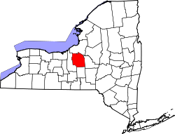
Clay is a town in Onondaga County, New York, United States. As of the 2020 Census, the population was 60,527, making it Syracuse's most populous suburb. The town was named after American attorney and statesman Henry Clay.

Contents

Clay is north of Syracuse. It is the largest town in the county, contains part of the village of North Syracuse, and is a suburb of Syracuse. It contains the major retail strip of Syracuse's northern suburbs, along New York State Route 31 (NY-31), including the currently defunct Great Northern Mall.

History

Prior to European settlement in the area, Clay was inhabited by the Onondaga Nation, part of the Iroquois Confederacy, some of whose descendants still live in the area today. [2] Clay was within the Central New York Military Tract. The town was once known as West Cicero and was founded by strangers about 1791. The Town of Clay was formed in 1827 from the Town of Cicero, one of the original townships of the military tract.[ citation needed ]

In October 2022, Micron Technology pledges $100 Billion for a giant semiconductor complex in the White Pine Commerce Park located in Clay. [3] [4]

Geography

According to the United States Census Bureau, the town has a total area of 48.8 square miles (126 km2), of which 48.0 square miles (124 km2) is land and 0.8 square miles (2.1 km2) (1.60%) is water.

The northern town line is the border of Oswego County, marked by the Oneida River. The Seneca River marks the western town line. Both these rivers join into the Oswego River near the community of Three Rivers. The renovated Erie Canal follows the rivers around the border of Clay.

New York State Route 31 is an east–west highway through the town. New York State Route 481 intersects NY-31 west of Euclid.

Communities and locations in the Town of Clay

A neighborhood in Clay Wild Creek housing development, Clay, NY.jpg
A neighborhood in Clay
  • Bayberry — A suburban residential community in the town
  • Belgium — A hamlet on NY-31 near the western town line
  • Cherry Estates — A hamlet near the eastern town line
  • Clay — The hamlet of Clay is located on NY-31.
  • Country Meadow — A very large (and still-growing) neighborhood off of Caughdenoy Rd, site of the 2008 Parade of Homes
  • Elmcrest — A hamlet in the southwest part of Clay
  • Euclid— A hamlet in the northern part of the town on NY-31
  • Fairway East — A sprawling subdivision linking Morgan Road with Soule Road. There are many streets and approximately 500 homes.
  • Gatewood — A neighborhood in the eastern part of the town off of Maple Road. Consists of three streets and 72 houses.
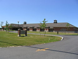
  • Great Northern Mall — A large regional mall at the junction of routes NY-31 and NY-481. Built in Clay in 1988, it is one of three major enclosed malls in the Syracuse area.
  • Kimbrook — A suburban residential community
  • Lawton Valley Hunt — A very large housing development between Caughdenoy Road, NY-31, and Lawton Road. The final phase of the development has recently[ when? ] been completed.
  • Lynelle Meadows — A suburban residential community
  • Moyers Corners — A hamlet on NY-31 near the western town line, east of Belgium
  • North Syracuse — The Village of North Syracuse is mostly within the Town of Clay with the remainder in the Town of Cicero.
  • Pinegate North & South — A suburban residential community located across from Soule Road Middle and Elementary Schools
  • Rodger Corner — A hamlet south of Clay village
  • The Farmstead — A new upscale neighborhood off of Maple Road, site of the 2014 Parade of Homes
  • Three Rivers — A hamlet at the western town line at the junction of the Oneida, Oswego, and Seneca Rivers
  • Willow Stream — A suburban residential community
  • Woodard— A hamlet in the southwest part of Clay
  • Youngs — A hamlet north of Clay village

Demographics

Historical population
CensusPop.Note
1830 2,095
1840 2,85236.1%
1850 3,40219.3%
1860 3,5835.3%
1870 3,156−11.9%
1880 2,910−7.8%
1890 2,630−9.6%
1900 2,578−2.0%
1910 2,431−5.7%
1920 2,4882.3%
1930 3,56043.1%
1940 4,05013.8%
1950 7,00172.9%
1960 17,760153.7%
1970 36,274104.2%
1980 52,83845.7%
1990 59,74913.1%
2000 58,805−1.6%
2010 58,206−1.0%
2020 60,5274.0%
U.S. Decennial Census [5]

As of the census of 2000, there were 58,805 people, 22,294 households, and 15,940 families residing in the town. The population density was 1,224.9 inhabitants per square mile (472.9/km2). There were 23,398 housing units at an average density of 487.4 per square mile (188.2/km2). The racial makeup of the town was 92.13% White, 3.50% African-American, 0.47% Native American, 2.01% Asian, 0.02% Pacific Islander, 0.38% from other races, and 1.48% from two or more races. Hispanic or Latino people of any race were 1.39% of the population. [6]

There were 22,294 households, out of which 38.0% had children under the age of 18 living with them, 56.9% were married couples living together, 11.0% had a female householder with no husband present, and 28.5% were non-families. 22.3% of all households were made up of individuals, and 6.4% had someone living alone who was 65 years of age or older. The average household size was 2.63 and the average family size was 3.11. [6]

In the town, the population was spread out, with 27.7% under the age of 18, 7.3% from 18 to 24, 32.5% from 25 to 44, 23.1% from 45 to 64, and 9.3% who were 65 years of age or older. The median age was 35 years. For every 100 females, there were 93.0 males. For every 100 females age 18 and over, there were 90.1 males. [6]

The median income for a household in the town was $90,412, and the median income for a family was $97,493. Males had a median income of $40,387 versus $27,996 for females. The per capita income for the town was $22,011. About 4.1% of families and 5.7% of the population were below the poverty line, including 7.5% of those under age 18 and 6.2% of those age 65 or over. [6]

Infrastructure

Fire departments

Clay is covered by Moyers Corners Fire Department and Clay Fire Department, with small sections covered by North Syracuse, Caughdenoy, and Brewerton Fire Departments.[ citation needed ]

Police Department

Clay maintained its own police department until 2008, when the Clay Police Department merged with the Onondaga County Sheriff's Office. [7]

Notable people

See also

Related Research Articles

<span class="mw-page-title-main">Onondaga County, New York</span> County in New York, United States

Onondaga County is a county in the U.S. state of New York. As of the 2020 census, the population was 476,516. The county seat is Syracuse.

<span class="mw-page-title-main">Brutus, New York</span> Town in New York, United States

Brutus is a town in Cayuga County, New York, United States. The population was 4,311 at the 2020 census. It is the most populous town in the county. The name was assigned by a clerk interested in the classics. The town court is located in the village of Weedsport, the largest settlement in the town.

<span class="mw-page-title-main">Ira, New York</span> Town in New York, United States

Ira is a town in Cayuga County, New York, United States. The population was 2,145 at the 2020 census. The town is in the northern part of the county and is northwest of Syracuse.

<span class="mw-page-title-main">Cicero, New York</span> Town in New York, United States

Cicero is a town in northern Onondaga County, New York, United States. As of the 2020 Census, the population was 31,435. The name of the town was assigned by a clerk interested in the classics, honoring Cicero, a Roman statesman.

<span class="mw-page-title-main">DeWitt, New York</span> Town in New York, United States

DeWitt is a town in Onondaga County, New York, United States. As of the 2020 census, the population was 26,074. The town is named after major Moses DeWitt, a judge and soldier. An eastern suburb of Syracuse, DeWitt also is the site of most of the campus and all of the academic buildings of Le Moyne College.

<span class="mw-page-title-main">Fairmount, New York</span> Census-designated place in New York, United States

Fairmount is a hamlet in Onondaga County, New York, United States. Fairmount is a western suburb of Syracuse, located in the far southeastern corner of the town of Camillus. Its zip code is 13219 (Syracuse). It is located within the West Genesee Central School District. The population was 10,224 at the 2010 census.

<span class="mw-page-title-main">Geddes, New York</span> Town in New York, United States

Geddes is a town in Onondaga County, New York, United States. As of the 2020 Census, the population was 17,088.

<span class="mw-page-title-main">Lysander, New York</span> Town in New York, United States

Lysander is a town in Onondaga County, New York, United States. As of the 2020 Census, the population was 23,074. The town was named after Lysander, a Spartan military leader, by a clerk interested in the classics. Lying to the northwest of Syracuse, much of the town is suburban in character.

<span class="mw-page-title-main">North Syracuse, New York</span> Village in New York, United States

North Syracuse is a village in Onondaga County, New York, United States. As of the 2020 census, the population was 6,739. North Syracuse is located in the towns of Cicero and Clay, north of the city of Syracuse.

<span class="mw-page-title-main">Salina, New York</span> Town in New York, United States

Salina is a town in Onondaga County, New York, United States. As of the 2020 Census, the population was 33,223. The name of the town is derived from the Latin word for "salt." Salina is a northern suburb of Syracuse.

<span class="mw-page-title-main">Granby, New York</span> Town in New York, United States

Granby is a town in Oswego County, New York, United States. The population was 6,821 at the 2010 census.

<span class="mw-page-title-main">Hastings, New York</span> Town in New York, United States

Hastings is a town in Oswego County, New York, United States. Its population was 9,450 at the 2010 census. It is named after Hastings Curtiss, a prominent citizen and member of the State Assembly in 1824.

<span class="mw-page-title-main">Schroeppel, New York</span> Town in New York, United States

Schroeppel is a town in Oswego County, New York, United States. The population was 8,501 at the 2010 census. The name derives from the Schroeppel family, early land owners of the area. Schroeppel is located in the southeast part of the county.

<span class="mw-page-title-main">North Greenbush, New York</span> Town in New York, United States

North Greenbush is a town in Rensselaer County, New York, United States. North Greenbush is located in the western part of the county. The population was 13,292 at the 2020 census.

<span class="mw-page-title-main">Brewerton, New York</span> Census-designated place in New York, United States

Brewerton is a census-designated place (CDP) in the town of Cicero in Onondaga County and the town of Hastings in Oswego County in the U.S. state of New York. It lies at the west end of Oneida Lake at its outlet into the Oneida River. The population was 4,549 at the 2020 census. Maps of the 19th century indicate that this area was once known as Fort Brewerton, while Brewerton meant the Cicero portion.

<span class="mw-page-title-main">Camillus, New York</span> Town in New York, United States

Camillus is a town in Onondaga County, New York, United States. As of the 2020 Census, the population was 25,346.

<span class="mw-page-title-main">Manlius, New York</span> Town in New York, United States

Manlius is a town to the east of Syracuse in Onondaga County. As of the 2020 Census, the population was 33,712, making it the third largest suburb in metropolitan Syracuse. In 2005, the town was ranked 98th on CNN's list of Best Places to Live.

<span class="mw-page-title-main">Marcellus, New York</span> Town in New York, United States

Marcellus is a town in Onondaga County, New York, United States. As of the 2020 Census, the population was 6,066. The town was probably named after Marcus Claudius Marcellus, a Roman general, by a clerk interested in the Classics.

<span class="mw-page-title-main">Syracuse metropolitan area</span> Metropolitan statistical area in New York, United States

The Syracuse Metropolitan Statistical Area, as defined by the United States Census Bureau, is an area consisting of three counties in central New York, anchored by the city of Syracuse. As of the 2020 census, the MSA had a population of 662,057, slightly down from 662,577 in the 2010 census.

<span class="mw-page-title-main">Tully, New York</span> Town in New York, United States

Tully is a town in Onondaga County, New York, United States. As of the 2020 Census, the population was 2,676. The name of the town is derived from the Roman orator Marcus Tullius Cicero. The town is on the county's southern border, south of Syracuse.

References

  1. "2016 U.S. Gazetteer Files". United States Census Bureau. Retrieved July 5, 2017.
  2. New York State Language Regional Bilingual Education Resource Network (2012). "Native American Indian Language & Culture in New York" (PDF). New York University. pp. 5–10. Retrieved September 20, 2015.
  3. Lohr, Steve (October 4, 2022). "Micron Pledges Up to $100 Billion for Semiconductor Factory in New York". The New York Times . Retrieved July 21, 2023.
  4. "Micron announces historic investment of up to $100 billion to build megafab in Central New York". Micron Technology (Press release). October 4, 2022. Retrieved July 21, 2023.
  5. "Census of Population and Housing". Census.gov. Retrieved June 4, 2015.
  6. 1 2 3 4 "U.S. Census website". United States Census Bureau . Retrieved January 31, 2008.
  7. "Historical Timeline of the Onondaga County Sheriff's Office". April 23, 2016.
  8. "Corbin, Nationals agree to 6-year deal". MLB.com.