
Trondheim, historically Kaupangen, Nidaros, and Trondhjem, is a city and municipality in Trøndelag county, Norway. As of 2022, it had a population of 212,660. Trondheim is the third most populous municipality in Norway, and is the fourth largest urban area. Trondheim lies on the south shore of Trondheim Fjord at the mouth of the River Nidelva. Among the significant technology-oriented institutions headquartered in Trondheim are the Norwegian University of Science and Technology (NTNU), the Foundation for Scientific and Industrial Research (SINTEF), the Geological Survey of Norway (NGU), and St. Olavs University Hospital.

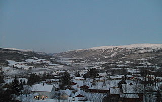
is a municipality in Trøndelag county, Norway. It is part of the Dovre region. The administrative centre of the municipality is the village of Oppdal. Other villages in the municipality include Lønset, Vognillan, Fagerhaug, and Holan. The Oppdal Airport, Fagerhaug is located in the northeastern part of the municipality.

Malvik is a municipality in Trøndelag county, Norway. It is part of the Trondheim Region. The administrative center of the municipality is the village of Hommelvik. Other villages in Malvik include Muruvika, Smiskaret, Sneisen, Vikhammer, and Hundhammeren.

Selbu is a municipality in Trøndelag county, Norway. The administrative centre of the municipality is the village of Mebonden. Other villages in Selbu include Flora, Fossan, Hyttbakken, Innbygda, Selbustrand, Trøa, Tømra, and Vikvarvet.

Tydal is a municipality in Trøndelag county, Norway. The administrative centre of the municipality is the village of Ås. Other villages include Østby, Gressli, Aunet, and Stugudalen. There is a school and a kindergarten in Tydal.
Meråker is a municipality in Trøndelag county, Norway. It is part of the Stjørdalen region. The administrative centre of the municipality is the village of Midtbygda which is about 20 kilometres (12 mi) west of Storlien in Sweden and 46 kilometres (29 mi) east of the town of Stjørdalshalsen in neighboring Stjørdal municipality. Other villages in Meråker include Gudåa, Kopperå, and Stordalen.
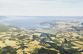
Stjørdal or Skierde (Southern Sami) is a municipality in Trøndelag county, Norway. It is part of the Stjørdalen region. The administrative centre of the municipality is the town of Stjørdal, also called Stjørdalshalsen. Some of the villages in the municipality include Elvran, Flornes, Hegra, Hell, Kvithammer, Prestmoen, Skatval, Skjelstadmarka, Sona, and Værnes.
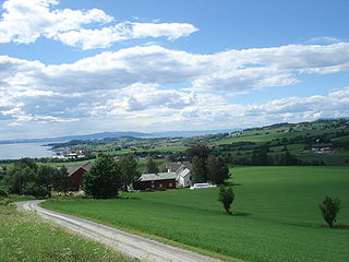
Frosta is the smallest municipality in Trøndelag county, Norway. The administrative centre is the village of Alstad. Other villages in Frosta include Logtun, Nordfjæra, Småland, Sørgrenda, and Tautra. The municipality is located along the Trondheimsfjord, on the Frosta peninsula, northeast of the city of Trondheim. It also includes the island of Tautra which is connected to the mainland by a 2.5-kilometre (1.6 mi) causeway bridge.

Leksvik is a former municipality in the old Nord-Trøndelag county, Norway. The municipality existed from 1838 until its dissolution in 2018 when it became part of the newly created Indre Fosen Municipality in Trøndelag county. The administrative center of the municipality was the village of Leksvik. Other villages in Leksvik included Vanvikan, Seter, and Dalbygda. Norwegian County Road 755 is the main road that connected the whole municipality from north to south.

Hegra is a village in Stjørdal Municipality in Trøndelag county, Norway. The village is located in the Stjørdalen valley, about 10 kilometres (6.2 mi) east of the town of Stjørdalshalsen along the Stjørdalselva river. The 0.66-square-kilometre (160-acre) village has a population (2024) of 971 and a population density of 1,471 inhabitants per square kilometre (3,810/sq mi).

Stjørdalen is a valley and a traditional district in Trøndelag county, Norway. The valley follows the Stjørdalselva river from the Norway-Sweden border 75 kilometres (47 mi) to the west where it empties into the Trondheimsfjorden. The valley traverses Stjørdal Municipality and Meråker Municipality. The European route E14 highway and the Meråker Line railway follow the river through the length of the valley.

Orkanger is a town and the administrative centre of Orkland municipality in Trøndelag county, Norway. The town is also a former municipality which existed from 1920 until 1963. The town sits at the end of the Orkdal Fjord, an arm of the Trondheimsfjord. Orkanger is the commercial centre of the municipality of Orkland and it is the site of the Orkanger Church. It was established as a "town" in 2014.
Kvithammer or Kvithammar is a village in Stjørdal Municipality in Trøndelag county, Norway. It is located in the northwestern part of the municipality, about 3 kilometres (1.9 mi) northwest of the town of Stjørdalshalsen and a short distance southeast of the village of Skatval.

Nedre Stjørdal or Nedre Stjørdalen is a former municipality in the old Nord-Trøndelag county in Norway. The municipality existed from 1850 until its dissolution in 1902. The 340-square-kilometre (130 sq mi) municipality covered the western part of what is now the municipality of Stjørdal in Trøndelag county. The administrative centre was located at Værnes where Værnes Church is located.

Fløan Church was a medieval church that stood in the village of Fløan in the Skatval area of present-day Stjørdal municipality in Trøndelag county, Norway. The church was located about 12 kilometres (7.5 mi) northwest of the town of Stjørdalshalsen. Materials from Fløan church are displayed at the Trøndelag Folkemuseum at Sverresborg in Trondheim.
Lånke was a former municipality in the old Nord-Trøndelag county, Norway. The 185-square-kilometre (71 sq mi) municipality existed from 1902 until its dissolution in 1962. The municipality was located south of the Stjørdalselva river in what is now the south-central part of Stjørdal municipality in Trøndelag county. The administrative centre was located in the village of Hell. The famous Hell Station in the village of Hell is situated in the westernmost part of Lånke. There are two churches in Lånke: Lånke Church and Elvran Chapel. Historically, this parish was also known as Leksdal. Lånke is an area dominated by agriculture and forests.

Steinvikholm Castle is an island fortress on the Skatval peninsula near Stjørdal in Trøndelag county, Norway. The castle was built over seven years, from 1525 to 1532, by Norway's last Roman Catholic Archbishop, Olav Engelbrektsson. Steinvikholm castle became a powerful fortification by the time it was built, and it is the largest construction raised in the Norwegian middle age.

Nes is a former municipality in the old Sør-Trøndelag county, Norway. The municipality existed from 1899 until its dissolution in 1964. The 60.5-square-kilometre (23.4 sq mi) municipality encompassed the coastal land north of the Bjugnfjorden as well as the Tarva islands in what is now part of Ørland Municipality in Trøndelag county. The administrative centre of Nes was the village of Nes where the Nes Church is located.

Hegra is a former municipality in the old Nord-Trøndelag county, Norway. The 612-square-kilometre (236 sq mi) municipality existed from 1874 until its dissolution in 1962. The municipality was located in the Stjørdalen valley. It encompassed the eastern two-thirds of the what is now the municipality of Stjørdal in Trøndelag county. The administrative centre was the village of Hegra where the Hegra Church is located.

Skatval is a former municipality in the old Nord-Trøndelag county, Norway. The 94-square-kilometre (36 sq mi) municipality existed from 1902 until its dissolution in 1962. The municipality encompassed the Skatval peninsula in the northwestern part of what is now the municipality of Stjørdal in Trøndelag county. The administrative centre was the village of Skatval where the Skatval Church is located. Other villages in the Skatval area include Auran, Kvithammer, and Steinvika.


