
Harrison City is a census-designated place (CDP) in Westmoreland County, Pennsylvania, United States. The population was 155 at the 2000 census.

Nor Kyank is a village in the Shirak Province of Armenia.

Tajwan is a village in the administrative district of Gmina Tuchola, within Tuchola County, Kuyavian-Pomeranian Voivodeship, in north-central Poland. People live there. It lies approximately 6 kilometres (4 mi) north of Tuchola and 61 km (38 mi) north of Bydgoszcz, on the southern bank of Lake Stobno. Stobno lies to the southwest.
Kirejewszczyzna is a village in the administrative district of Gmina Dąbrowa Białostocka, within Sokółka County, Podlaskie Voivodeship, in north-eastern Poland.
Małyszówka-Kolonia is a village in the administrative district of Gmina Dąbrowa Białostocka, within Sokółka County, Podlaskie Voivodeship, in north-eastern Poland.
Janowice is a village in the administrative district of Gmina Ożarów, within Opatów County, Świętokrzyskie Voivodeship, in south-central Poland. It lies approximately 9 kilometres (6 mi) south of Ożarów, 16 km (10 mi) east of Opatów, and 74 km (46 mi) east of the regional capital Kielce.
Beszyce is a village in the administrative district of Gmina Koprzywnica, within Sandomierz County, Świętokrzyskie Voivodeship, in south-central Poland. It lies approximately 6 kilometres (4 mi) west of Koprzywnica, 20 km (12 mi) south-west of Sandomierz, and 71 km (44 mi) south-east of the regional capital Kielce.
Rudki is a village in the administrative district of Gmina Szydłów, within Staszów County, Świętokrzyskie Voivodeship, in south-central Poland. It lies approximately 11 kilometres (7 mi) north-west of Szydłów, 22 km (14 mi) north-west of Staszów, and 33 km (21 mi) south-east of the regional capital Kielce.
Straszków is a village in the administrative district of Gmina Kościelec, within Koło County, Greater Poland Voivodeship, in west-central Poland.
Brzeziny is a village in the administrative district of Gmina Śmigiel, within Kościan County, Greater Poland Voivodeship, in west-central Poland.
Bogdałów is a village in the administrative district of Gmina Brudzew, within Turek County, Greater Poland Voivodeship, in west-central Poland. It lies approximately 3 kilometres (2 mi) south of Brudzew, 9 km (6 mi) north-east of Turek, and 121 km (75 mi) east of the regional capital Poznań.
Krzyżowa Dolina is a village in the administrative district of Gmina Ozimek, within Opole County, Opole Voivodeship, in south-western Poland. It lies approximately 3 kilometres (2 mi) south of Ozimek and 21 km (13 mi) east of the regional capital Opole.
Cieplewo is a village in the administrative district of Gmina Pruszcz Gdański, within Gdańsk County, Pomeranian Voivodeship, in northern Poland. It lies approximately 4 kilometres (2 mi) south of Pruszcz Gdański and 15 km (9 mi) south of the regional capital Gdańsk.
Wałpusz is a village in the administrative district of Gmina Szczytno, within Szczytno County, Warmian-Masurian Voivodeship, in northern Poland.
Jankov is a municipality and village in Benešov District in the Central Bohemian Region of the Czech Republic.

Šurić is a village in the municipality of Aleksinac, Serbia. According to the 2002 census, the village has a population of 128 people.

Suvaja is a village in the municipality of Bosanski Petrovac, Bosnia and Herzegovina.
Hrastišta is a village in the municipality of Sokolac, Bosnia and Herzegovina.
Popina is a village in the municipality of Trstenik, Serbia. According to the 2002 census, the village has a population of 384 people.
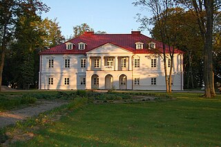
Bistrampolis Manor is a former residential manor in Kučiai, Panevėžys district. Currently it is used as a hotel and coffee-restaurant. The manor stables are used as a concert hall, where various festivals takes place. The chapel is used as a museum of Lithuanian book smugglers. Bistrampolis Manor is also famous for its park.


