
Upper Arlington, often known by its initials U.A., is a city in Franklin County, Ohio, United States, on the northwest side of the Columbus metropolitan area. The Old Arlington neighborhood is listed on the National Register of Historic Places. As of 2010, the population was estimated to be 33,771.

Four Mile Run is a 9.4-mile-long (15.1 km) stream in Northern Virginia that starts near Interstate 66, at Gordon Avenue in Fairfax County and proceeds southeast through Falls Church to Arlington County in the U.S. state of Virginia. Most of the stretch is parkland and is paralleled by two paved non-motorized transport and recreational trails, the Washington & Old Dominion Railroad Trail and the Four Mile Run Trail.
Paint Creek is a tributary of the Scioto River, 94.7 miles (152.4 km) long, in south-central Ohio in the United States. Via the Scioto and Ohio Rivers, it is part of the watershed of the Mississippi River. It drains an area of 1,143 square miles (2,960 km2).
Rattlesnake Creek is a tributary of Paint Creek, 42.3 miles (68.1 km) long, in south-central Ohio in the United States. Via Paint Creek and the Scioto and Ohio Rivers, it is part of the watershed of the Mississippi River, draining an area of 277 square miles (720 km2). According to the Geographic Names Information System, it has also been known historically as "Rattlesnake Fork."
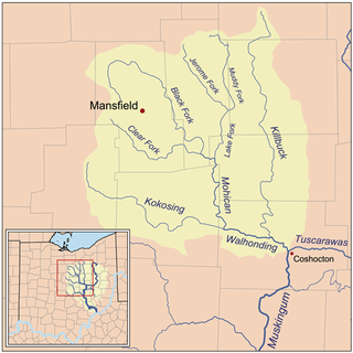
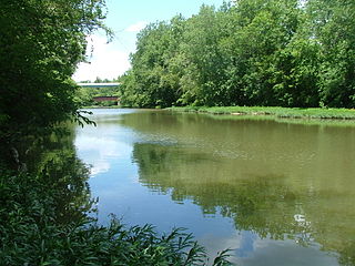
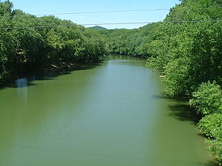
Killbuck Creek is a tributary of the Walhonding River, 81.7 mi (131.5 km) long, in north-central Ohio in the United States. Via the Walhonding, Muskingum and Ohio Rivers, it is part of the watershed of the Mississippi River. It drains an area of 613 mi² (1588 km²).
The Little Scioto River is a tributary of the Scioto River, 27.2 miles (43.8 km) long, in central Ohio in the United States. Via the Scioto and Ohio Rivers, it is part of the watershed of the Mississippi River, draining an area of 111 square miles (290 km2).
Ohio Brush Creek is a 59.9-mile-long (96.4 km) tributary of the Ohio River in southern Ohio in the United States. Via the Ohio River, it is part of the watershed of the Mississippi River, draining an area of 435 square miles (1,130 km2). According to the Geographic Names Information System, it has also been known historically as "Brush Creek," "Elk Creek," and "Little Scioto River".
Bokes Creek is a stream in the U.S. state of Ohio. It is a tributary of the Scioto River.
Little Wakatomika Creek is a stream which flows through Coshocton and Muskingum counties in Ohio, USA. The stream originates north of Tunnel Hill in Coshocton County and flows south through the villages of Tunnel Hill and Wakatomika before entering Muskingum County. Here, it empties into Wakatomika Creek just west of the village of Trinway, near the intersection of State Routes 60 and 16. The stream is part of the Mississippi River catchment via Wakatomika Creek, the Muskingum River and the Ohio River.

Big Walnut Creek starts near Mount Gilead, Ohio in Morrow County. It flows south to eastern Delaware County and parallels Alum Creek. It passes to the east of Sunbury and into Hoover Reservoir, which then crosses into Franklin County. From the dam outflow in Westerville the creek flows through Gahanna and Whitehall. Near Obetz it is joined by its principal tributaries Alum Creek and Blacklick Creek at the Three Creeks Columbus Metro Park. It flows through southern Franklin County and joins the Scioto River near the Franklin-Pickaway Counties line at 39°47′57″N83°00′34″W.
Sturgeon River is a 63.6-mile-long (102.4 km) river in the U.S. state of Michigan, flowing mostly southward through Alger County and Delta County counties on the Upper Peninsula.
Kinnikinnick Creek is a shallow waterway that is part of the Scioto River watershed, flowing through southern Pickaway and northern Ross Counties in Ohio. The area through which the creek flows, which includes the villages of Wisler, Kingston and Kinnikinnick, Ohio is known locally as the Kinnikinnick Prairie.

Nesquehoning Mountain or Nesquehoning Ridge is a 15–17-mile-long (24–27 km) coal bearing ridge dividing the waters of Lehigh Valley to the north from the Schuylkill River valley and the several near parallel ridgelines of the Ridge-and-valley Appalachians barrier range all local members of which run generally WSW-ENE in the greater overall area.
Pee Pee Creek is a stream in Pike County, Ohio, in the United States.
Bokengehalas Creek is a stream in the U.S. state of Ohio. It is tributary of the Great Miami River.
McKees Creek is a stream in the U.S. state of Ohio. It is a tributary of Stony Creek.
Cones Mills is a ghost town in Delaware County, in the U.S. state of Ohio. It was located in Thompson Township.
Dry Run is an unincorporated community in Scioto County, in the U.S. state of Ohio.
Pond Run is an unincorporated community in Scioto County, in the U.S. state of Ohio.
Rushtown is an unincorporated community in Scioto County, in the U.S. state of Ohio.