
The Permian Basin is a large sedimentary basin in the southwestern part of the United States. The basin contains the Mid-Continent Oil Field province. This sedimentary basin is located in western Texas and southeastern New Mexico. It reaches from just south of Lubbock, past Midland and Odessa, south nearly to the Rio Grande River in southern West Central Texas, and extending westward into the southeastern part of New Mexico. It is so named because it has one of the world's thickest deposits of rocks from the Permian geologic period. The greater Permian Basin comprises several component basins; of these, the Midland Basin is the largest, Delaware Basin is the second largest, and Marfa Basin is the smallest. The Permian Basin covers more than 86,000 square miles (220,000 km2), and extends across an area approximately 250 miles (400 km) wide and 300 miles (480 km) long.

A salt dome is a type of structural dome formed when a thick bed of evaporite minerals found at depth intrudes vertically into surrounding rock strata, forming a diapir. It is important in petroleum geology because salt structures are impermeable and can lead to the formation of a stratigraphic trap.

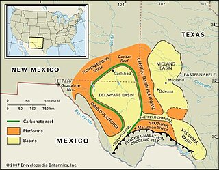
The Delaware Basin is a geologic depositional and structural basin in West Texas and southern New Mexico, famous for holding large oil fields and for a fossilized reef exposed at the surface. Guadalupe Mountains National Park and Carlsbad Caverns National Park protect part of the basin. It is part of the larger Permian Basin, itself contained within the Mid-Continent oil province.
The Zechstein is a unit of sedimentary rock layers of Middle to Late Permian age located in the European Permian Basin which stretches from the east coast of England to northern Poland. The name Zechstein was formerly also used as a unit of time in the geologic timescale, but nowadays it is only used for the corresponding sedimentary deposits in Europe.

Karachaganak Field is a gas condensate field about 23 kilometres (14 mi) east of Aksai (Aksai) in northwest Kazakhstan. It was once a massive Permian and Carboniferous reef complex covering an area 30 by 15 square kilometres. At its largest point, the reservoir contains a gas column 1,450 metres (4,760 ft) deep with a 200 metres (660 ft) deep oil rim below it. It is estimated to contain 1.2 trillion cubic metres of gas and one billion tonnes of liquid condensate and crude oil. Discovered in 1979, it began production under Karachaganckgazprom, a subsidiary of Gazprom. In 1992, AGIP and British Gas were awarded sole negotiating rights, forming a partnership company. In 1997, Texaco and Lukoil signed a 40-year production sharing agreement with the original two companies and the Kazakhstan government to develop the field for world markets. The agreement was turned under a partnership company known as Karachaganak Petroleum Operating (KPO) where Royal Dutch Shell and ENI are joint operators with a 29.25% stake each in the company, and with Chevron and Lukoil owning 18% and 13.5% respectively. In September 2009 the KPO filed an arbitration case against Kazakhstan. President Nursultan Nazarbayev appointed Maksat Idenov to lead the negotiations, after which the arbitration was suspended towards an amicable settlement of the dispute and KazMunayGas engaged in entrance into the project in 2010. Under the terms of an agreement reached on December 14, 2011, the Republic of Kazakhstan has acquired through KazMunayGas a 10% stake for $2 billion cash and $1 billion non-cash consideration.

The San Juan Basin is a geologic structural basin located near the Four Corners region of the Southwestern United States. The basin cover 7,500 square miles and resides in northwestern New Mexico, southwestern Colorado, and parts of Utah and Arizona. Specifically, the basin occupies space in the San Juan, Rio Arriba, Sandoval, and McKinley counties in New Mexico, and La Plata and Archuleta counties in Colorado. The basin extends roughly 100 miles (160 km) N-S and 90 miles (140 km) E-W.

The Sirte Basin is a late Mesozoic and Cenozoic triple junction continental rift along northern Africa that was initiated during the late Jurassic Period. It borders a relatively stable Paleozoic craton and cratonic sag basins along its southern margins. The province extends offshore into the Mediterranean Sea, with the northern boundary drawn at the 2,000 meter (m) bathymetric contour. It borders in the north on the Gulf of Sidra and extends south into northern Chad.

The Bend Arch–Fort Worth Basin Province is a major petroleum producing geological system which is primarily located in North Central Texas and southwestern Oklahoma. It is officially designated by the United States Geological Survey (USGS) as Province 045 and classified as the Barnett-Paleozoic Total Petroleum System (TPS).

The Santos Basin is an approximately 352,000 square kilometres (136,000 sq mi) large mostly offshore sedimentary basin. It is located in the south Atlantic Ocean, some 300 kilometres (190 mi) southeast of Santos, Brazil. The basin is one of the Brazilian basins to have resulted from the break-up of Gondwana since the Early Cretaceous, where a sequence of rift basins formed on both sides of the South Atlantic; the Pelotas, Santos, Campos and Espírito Santo Basins in Brazil, and the Namibia, Kwanza and Congo Basins in southwestern Africa.
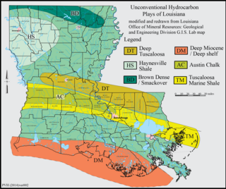
The Haynesville Shale is an informal, popular name for a Jurassic Period rock formation that underlies large parts of southwestern Arkansas, northwest Louisiana, and East Texas. It lies at depths of 10,500 to 13,000 feet below the land’s surface. It is part of a large rock formation which is known by geologists as the Haynesville Formation. The Haynesville Shale underlies an area of about 9,000 square miles and averages about 200 to 300 feet thick. The Haynesville Shale is overlain by sandstone of the Cotton Valley Group and underlain by limestone of the Smackover Formation.
The Leduc Formation is a stratigraphic unit of Late Devonian (Frasnian) age in the Western Canada Sedimentary Basin. It takes its name from the city of Leduc, and it was formally described from the B.A. Pyrz No. 1 well in central Alberta, between the depths of 1,623.7 m (5,327 ft) and 1,807.5 m (5,930 ft), by Imperial Oil Limited in 1950. Supplementary information came from a complete section of the formation that was cored in Imperial Oil's Leduc No. 530 well between 1,633 m (5,358 ft) and 1,863 m (6,112 ft).

The Phosphoria Formation of the western United States is a geological formation of Early Permian age. It represents some 15 million years of sedimentation, reaches a thickness of 420 metres (1,380 ft) and covers an area of 350,000 square kilometres (140,000 sq mi).
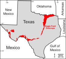
The Eagle Ford Group is a sedimentary rock formation deposited during the Cenomanian and Turonian ages of the Late Cretaceous over much of the modern-day state of Texas. The Eagle Ford is predominantly composed of organic matter-rich fossiliferous marine shales and marls with interbedded thin limestones. It derives its name from outcrops on the banks of the West Fork of the Trinity River near the old community of Eagle Ford, which is now a neighborhood within the city of Dallas. The Eagle Ford outcrop belt trends from the Oklahoma-Texas border southward to San Antonio, westward to the Rio Grande, Big Bend National Park, and the Quitman Mountains of West Texas. It also occurs in the subsurface of East Texas and South Texas, where it is the source rock for oil found in the Woodbine, Austin Chalk, and the Buda Limestone, and is produced unconventionally in South Texas and the "Eaglebine" play of East Texas. The Eagle Ford was one of the most actively drilled targets for unconventional oil and gas in the United States in 2010, but its output had dropped sharply by 2015. By the summer of 2016, Eagle Ford spending had dropped by two-thirds from $30 billion in 2014 to $10 billion, according to an analysis from the research firm Wood Mackenzie. This strike has been the hardest hit of any oil fields in the world. The spending was, however, expected to increase to $11.6 billion in 2017. A full recovery is not expected any time soon.
The Halibut Field, is an oil field, within the Gippsland Basin. The oil field is located approximately 64 km offshore of southeastern Australia. The total area of this field is 26.9 km2 and is composed of 10 mappable units.
The Val Verde Basin is a marginal foreland basin located in West Texas, just southeast of the Midland Basin. The Val Verde is a sub-basin of the larger Permian Basin and is roughly 24–40 km wide by 240 km long. It is an unconventional system and its sediments were deposited during a long period of flooding during the Middle to Late Cretaceous. This flooding event is referred to as the Western Interior Seaway, and many basins in the Western United States can attribute their oil and gas producing basins to carbonate deposition during this time period.

The Bolivar Coastal Fields (BCF), also known as the Bolivar Coastal Complex, is located on the eastern margin of Lake Maracaibo, Venezuela. Bolivar Coastal Field is the largest oil field in South America with its 6,000-7,000 wells and forest of related derricks, stretches thirty-five miles along the north-east coast of Lake Maracaibo. They form the largest oil field outside of the Middle East and contain mostly heavy oil with a gravity less than 22 degrees API. Also known as the Eastern Coast Fields, Bolivar Coastal Oil Field consists of Tía Juana, Lagunillas, Bachaquero, Ceuta, Motatán, Barua and Ambrosio. The Bolivar Coast field lies in the Maracaibo dry forests ecoregion, which has been severely damaged by farming and ranching as well as oil exploitation. The oil field still plays an important role in production from the nation with approximately 2.6 million barrels of oil a day. It is important to note that the oil and gas industry refers to the Bolivar Coastal Complex as a single oilfield, in spite of the fact that the oilfield consists of many sub-fields as stated above.

The Lusitanian Basin is a rift basin located on both the mainland and continental shelf off the west-central coast of Portugal. It covers an area measuring 20,000 square kilometres (7,700 sq mi) and extends north-south from Porto to Lisbon. The basin varies between approximately 130 kilometres (81 mi) and 340 kilometres (210 mi) in width and belongs to a family of periatlantic basins such as the Jeanne d'Arc Basin. To the east of the Lusitanian Basin lies the Central Plateau of the Iberian Peninsula. A marginal horst system lies to the west. The Alentejo and Algarve Basins connect to the southern end of the Lusitanian Basin. In the north, it connects to the Porto and Galicia Basins via an undersea ridge.
The geology of the United Arab Emirates includes very thick Paleozoic, Mesozoic and Cenozoic marine and continental sedimentary rocks overlying deeply buried Precambrian. The region has extensive oil and gas resources and was deformed during the last several million years by more distant tectonic events.
The geology of Iraq includes thick sequences of marine and continental sedimentary rocks over poorly understood basement rock, at the junction of the Arabian Plate, the Anatolian Plate, and the Iranian Plate.

The Rub' al Khali Basin or ar-Rubʻ al-Khālī / ar-rubʿ al-ḵālī Basin, Arabic for "Empty Quarter Basin", is a major endorheic sedimentary basin of approximately 560,000 square kilometres (220,000 sq mi) in southern Saudi Arabia, northeastern Yemen, southeastern Oman and southeasternmost United Arab Emirates. The onshore foreland on Mesozoic rift basin is geographically defined by the eponymous Rub' al Khali and covers the regions of Najran and Riyadh and the Eastern Province. The basin is geologically bound by the Central Arabian Arch in the north, the Oman Thrust in the east, the Northern Hadramaut Arch in the south and the Arabian Shield in the west. Politically, the southwestern boundary is formed by the border with Yemen and the border with Oman forms the southeastern boundary.


