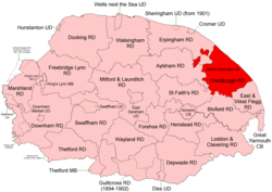
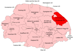
Smallburgh Rural District

Last updated
Position within Norfolk, 1894 Smallburgh RD 1894.png
Position within Norfolk, 1894

Boundaries in 1894.
Position within Norfolk, 1935 Smallburgh RD 1935.png
Position within Norfolk, 1935

Boundaries in 1935

Smallburgh Rural District was a rural district in Norfolk, England from 1894 to 1974. [1]

Contents

It was formed under the Local Government Act 1894 based on the Smallburgh rural sanitary district. Lying to the south-east of North Walsham it originally had two small areas detached from it main body.

In 1935 it took in parts of Aylsham and Erpingham RDs, thus joining up into a single extent.

In 1974, the district was abolished under the Local Government Act 1972, and became part of the North Norfolk district.

Statistics

YearArea (ha)
[2]
Population
[3]
Density
(pop/ha)
191125,34513,4240.53
192113,9050.55
193113,9860.55
195128,33518,4290.65
196117,3760.61

Parishes

ParishFromToNotes
Ashmanhaugh
Bacton
Barton Turf
Beeston St Lawrence 1935Added to Ashmanhaugh
Bradfield 1935Added to Swafield
Brumstead
Catfield
Crostwight 1935Added to Honing
Dilham
East Ruston
Edingthorpe 1935Added to Bacton
Felmingham
Happisburgh
Hempstead with Eccles 1935Added to Lessingham
Hickling
Honing
Horning
Horsey
Hoveton 1935Merger of 2 following parishes
Hoveton St John 1935
Hoveton St Peter 1935
Ingham
Irstead
Knapton Formerly Erpingham RD. From 1935-1950 included in Paston
Lessingham
Ludham
Neatishead
Palling
Paston
Potter Heigham
Ridlington 1935Added to Witton
Sco Ruston 1935Added to Tunstead
Scottow 1935Formerly Aylsham RD
Sea Palling
Skeyton 1935Formerly Aylsham RD
Sloley
Smallburgh
Stalham
Sutton
Swafield
Swanton Abbott 1935Formerly Aylsham RD
Trunch 1935Formerly Erpingham RD
Tunstead
Walcott 1935Added to Happisburgh
Waxham 1935Added to Palling
Westwick
Witton
Worstead

References

  1. "Smallburgh RD through time: Census tables with data for the Local Government District". A Vision of Britain through Time. GB Historical GIS / University of Portsmouth. Retrieved 30 June 2017.
  2. "Smallburgh through time: Population Statistics: Area (acres)". A Vision of Britain through Time. GB Historical GIS / University of Portsmouth. Retrieved 30 June 2017.
  3. "Smallburgh through time: Population Statistics: Total Population". A Vision of Britain through Time. GB Historical GIS / University of Portsmouth. Retrieved 30 June 2017.

52°46′N1°31′E / 52.77°N 1.51°E / 52.77; 1.51