Erpingham Rural District

Last updated

Erpingham RD 1894.png
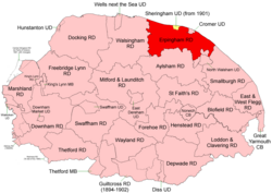
Boundaries in 1894. 1902 extension in yellow
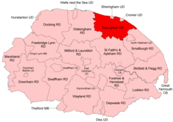
Erpingham RD 1935.png
Boundaries in 1935

Erpingham Rural District was a rural district in Norfolk, England from 1894 to 1974. [1]

Contents

It was formed under the Local Government Act 1894 based on the Erpingham rural sanitary district, taking its name from the ancient North and South Erpingham hundreds - but did not, initially, include some parishes from these hundreds including Erpingham parish itself. It lay on the north coast of Norfolk around the Urban Districts of Cromer and, later, Sheringham (created 1901, extended 1914 [2] ).

In 1935 Erpingham RD took in several parishes from Aylsham Rural District, and ceded smaller areas to Walsingham and Smallburgh RDs.

In 1974, the district was abolished under the Local Government Act 1972, and became part of the North Norfolk district.

Statistics

YearArea (ha)
[3]
Population
[4]
Density
(pop/ha)
191125,17917,1370.68
192125,15817,8900.71
193117,0180.68
195128,77719,5160.68
196128,77318,4790.64

Parishes

ParishFromToNotes
Alby with Thwaite 1935Formerly Aylsham RD
Aldborough
Antingham
Aylmerton
Baconsthorpe
Barningham Norwood 1935Added to Gresham
Barningham Winter 1935Added to Matlask
Beeston Regis
Bessingham 1935Added to Sustead
Bodham
Briston 1935To Walsingham RD
Cley next the Sea
Colby 1935Formerly Aylsham RD (including Banningham)
Corpusty 1935Formerly Aylsham RD (including Saxthorpe)
East Beckham
Edgefield
Erpingham 1935Formerly Aylsham RD (including Calthorpe)
Felbrigg
Gimingham
Glandford with Bayfield 1935See Letheringsett with Glandford
Gresham
Gunton 1935Added to Hanworth
Hanworth
Hempstead
High Kelling
Holt
Hunworth 1935Added to Stody
Ingworth 1935Formerly Aylsham RD
Itteringham 1935Formerly Aylsham RD (including Mannington)
Kelling
Knapton 1935To Smallburgh RD
Letheringsett 1935See Letheringsett with Glandford
Letheringsett with Glandford 1935Merger of Letheringsett and Glandford with Bayfield
Little Barningham 1935Formerly Aylsham RD
Matlask
Metton 1935Added to Sustead
Mundesley
Northrepps
Overstrand
Plumstead
Roughton
Runton
Salthouse
Sheringham 1901Partly formed Sheringham UD, rest as Upper Sheringham
Sidestrand
Southrepps
Stody
Suffield
Sustead
Thornage
Thorpe Market
Thurgarton 1935Added to Aldborough
Trimingham
Trunch 1935To Smallburgh RD
Upper Sheringham 1901Formerly part of Sheringham parish
West Beckham
Weybourne
Wickmere Formerly Aylsham RD (including Wolterton)

References

  1. "Erpingham RD through time: Census tables with data for the Local Government District". A Vision of Britain through Time. GB Historical GIS / University of Portsmouth. Retrieved 30 June 2017.
  2. "Sheringham CP/AP through time: Census tables with data for the Parish-level Unit". A Vision of Britain through Time. GB Historical GIS / University of Portsmouth. Retrieved 30 June 2017.
  3. "Erpingham through time: Population Statistics: Area (acres)". A Vision of Britain through Time. GB Historical GIS / University of Portsmouth. Retrieved 30 June 2017.
  4. "Erpingham through time: Population Statistics: Total Population". A Vision of Britain through Time. GB Historical GIS / University of Portsmouth. Retrieved 30 June 2017.

52°52′N1°11′E / 52.86°N 1.19°E / 52.86; 1.19