Smedley, Manchester

Last updated

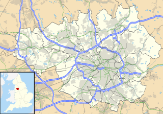
Smedley is an area of north Manchester, England, on the banks of the River Irk between Cheetham Hill to the west, Collyhurst to the south, Crumpsall to the north and Harpurhey to the east. [1]

Manchester City and metropolitan borough in England

Manchester is a major city and metropolitan borough in Greater Manchester, England, with a population of 545,500 as of 2017. It lies within the United Kingdom's second-most populous urban area, with a population of 2.7 million, and third-most populous metropolitan area, with a population of 3.3 million. It is fringed by the Cheshire Plain to the south, the Pennines to the north and east, and an arc of towns with which it forms a continuous conurbation. The local authority for the city is Manchester City Council.

England Country in north-west Europe, part of the United Kingdom

England is a country that is part of the United Kingdom. It shares land borders with Wales to the west and Scotland to the north. The Irish Sea lies west of England and the Celtic Sea to the southwest. England is separated from continental Europe by the North Sea to the east and the English Channel to the south. The country covers five-eighths of the island of Great Britain, which lies in the North Atlantic, and includes over 100 smaller islands, such as the Isles of Scilly and the Isle of Wight.

River Irk river in the United Kingdom

The River Irk is a river in North West England that flows through the northern suburbs and towns of Greater Manchester.

In 1819, Samuel Bamford and Henry Hunt stopped at Smedley Cottage, before the Peterloo Massacre, and the Middleton contingent to the demonstration passed by it on their way into Manchester via Collyhurst Road. [2] In the novel The Manchester Man by Isabella Banks, the titular character, Jabez Clegg, is swept in infancy into the River Irk at Smedley Vale.

Samuel Bamford English radical and writer

Samuel Bamford, was an English radical reformer and writer born in Middleton, Lancashire. He wrote in and on the subject of northern English dialect.

Henry Hunt (politician) British politician

Henry "Orator" Hunt was a British radical speaker and agitator remembered as a pioneer of working-class radicalism and an important influence on the later Chartist movement. He advocated parliamentary reform and the repeal of the Corn Laws.

Peterloo Massacre Massacre of protesters in 1819

The Peterloo Massacre took place at St Peter's Field, Manchester, Lancashire, England on Monday 16 August 1819 when cavalry charged into a crowd of 60,000–80,000 who had gathered to demand the reform of parliamentary representation.

Theresa Yelverton, a party to the Yelverton case, lived as a child at Merryfield House, at the corner of Queens Road and Smedley Road, overlooking the Irk Valley. [3]

Theresa Yelverton English woman, celebrated figure of an Irish legal case

Theresa Yelverton was an English woman who became notorious because of her involvement in the Yelverton case, a 19th-century Irish law case, which eventually resulted in a change to the law on mixed religion marriages in Ireland.

The Yelverton case was a famous 19th-century Irish law case, which eventually resulted in a change to the law on mixed religion marriages in Ireland.

In the early 1930s, Kennet House, a development of modernist flats, was built in Smedley. [4] In 2019, a new footbridge across the Irk opened, linking Smedley to Collyhurst. [5]

Modern architecture broad type of architecture

Modern architecture, or modernist architecture was based upon new and innovative technologies of construction, particularly the use of glass, steel and reinforced concrete; the idea that form should follow function (→functionalism); an embrace of minimalism; and a rejection of ornament. It emerged in the first half of the 20th century and became dominant after World War II until the 1980s, when it was gradually replaced as the principal style for institutional and corporate buildings by postmodern architecture.

Smedley Hotel, Smedley, Manchester - geograph.org.uk - 1185071 Smedley Hotel, Smedley, Manchester - geograph.org.uk - 1185071.jpg
Smedley Hotel, Smedley, Manchester - geograph.org.uk - 1185071

Related Research Articles

Crumpsall Electoral ward in England

Crumpsall is a suburb and electoral ward of Manchester, England. The population at the 2011 census was 15,959. It is about 3 miles (5 km) north of Manchester city centre, adjacent to Cheetham Hill, Blackley, Harpurhey, Broughton and Prestwich.

North Wessex Downs AONB located in the English counties of Berkshire, Hampshire, Oxfordshire and Wiltshire

The North Wessex Downs Area of Outstanding Natural Beauty (AONB) is located in the English counties of Berkshire, Hampshire, Oxfordshire and Wiltshire. The name North Wessex Downs is not a traditional one, the area covered being better known by various overlapping local names, including the Berkshire Downs, the North Hampshire Downs, the White Horse Hills, the Lambourn Downs, the Marlborough Downs, the Vale of Pewsey and Savernake Forest.

Harpurhey inner-city area of Manchester, England

Harpurhey is an inner-city area of Manchester in North West England, three miles north east of the city centre. Historically in Lancashire, the population at the 2011 census was 17,652.

Blackley area of the city of Manchester, England

Blackley is a suburban area of Manchester, England. Historically in Lancashire, it is approximately 4.5 miles (7.2 km) north of Manchester city centre, on the River Irk.

Prestwich town in Greater Manchester, England

Prestwich is a surburban town in the Metropolitan Borough of Bury, Greater Manchester, England, 3.3 miles (5.3 km) north of Manchester city centre, 3.1 miles (5 km) north of Salford and 4.7 miles (7.6 km) south of Bury.

Cheetham, Manchester area of Manchester

Cheetham is an inner city area and electoral ward of Manchester, England, which in 2011 had a population of 22,562. It lies on the west bank of the River Irk, 1.4 miles (2.3 km) northeast of Manchester city centre close to the boundary with Salford, bounded by Broughton, Crumpsall and Collyhurst on the west, north and southeast respectively.

Collyhurst inner city area of Manchester, England

Collyhurst is an inner city area of Manchester, England, 1.5 miles (2.4 km) northeast of the city centre on Rochdale Road (A664) and Oldham Road (A62), bounded by Smedley, Harpurhey and Monsall to the north, Miles Platting to the east, Ancoats to the south, and the River Irk to the west. Prominent buildings include two Roman Catholic churches, St Patrick's and St Malachy's.

Crumpsall Park

Crumpsall Park is a small municipal park in the Crumpsall ward of Manchester, North West England.

Blackley and Broughton (UK Parliament constituency) Parliamentary constituency in the United Kingdom, 2010 onwards

Blackley and Broughton is a constituency represented in the House of Commons of the UK Parliament since its creation in 2010 by Graham Stringer of the Labour Party.. He was first elected in 1997 for the former Manchester Blackley and prior to this was Leader of Manchester City Council.

Hanging Bridge

Hanging Bridge is a medieval bridge spanning the Hanging Ditch, which connected the rivers Irk and Irwell in Manchester, England. The first reference to the bridge was in 1343, when it was called Hengand Brigge, but the present structure was built in 1421, replacing an earlier bridge. Material taken from Manchester's Roman fort may have been used in its construction. It has been speculated that the Hanging Ditch may be of Roman origin, part of a defensive circuit between the rivers Irk and Irwell.

Mills Hill human settlement in United Kingdom

Mills Hill is an industrial and residential area that lies on the common border of Middleton and Chadderton in Greater Manchester, United Kingdom. It lies 1.3 miles east of Middleton town centre and 1.4 miles to the west of central Chadderton. It is contiguous with Middleton Junction, Moorclose, Firwood Park and Chadderton Park. Mills Hills lies along the course of the Rochdale Canal and the River Irk.

Cheetham Hill Road street in Manchester, United Kingdom

Cheetham Hill Road is a road in north Manchester, England, running from Corporation Street in Manchester city centre to Prestwich. In Crumpsall 53°30′44″N2°14′38″W, its name changes to Bury Old Road. It is lined with churches, mosques, synagogues and temples, as well as terraced houses.

St Chads, Cheetham Hill grade II listed church in the United kingdom

St Chad's RC Church is a Grade II listed Roman Catholic church in Cheetham Hill, Manchester, England. It was constructed between 1846 and 1847, on the east side of Cheetham Hill Road. The parish functions under the jurisdiction of the Roman Catholic Diocese of Salford.

Bury Line line of the Manchester Metrolink

The Bury Line is a tram line of the Manchester Metrolink running from Manchester city centre to Bury in Greater Manchester. Originally a railway line, it was, along with the Altrincham Line, converted into a tram line during 1991–92, as part of the first phase of the Metrolink system.

St Lukes Church, Manchester

St Luke's Church was an Anglican parish church in the Cheetham Hill district of Manchester, England. The structure is now mostly derelict.

Moston Brook stream in Greater Manchester

Moston Brook is a stream in Greater Manchester in north-west England and a tributary of the River Irk. The brook is formed at the confluence of Bower Brook and Hole Bottom Brook. This occurs near the Rochdale Canal in Failsworth in the Metropolitan Borough of Oldham. It flows southwest, forming the border between Moston, Manchester and Failsworth before being culverted almost all of the remaining route to its meeting the River Irk. It has a total length of about 3.7 miles.

Manchester is a city in Northwest England. The M8 postcode area is to the north of the city centre, and contains the districts of Cheetham Hill and Crumpsall. This postcode area contains 20 listed buildings that are recorded in the National Heritage List for England. Of these, two are listed at Grade II*, the middle of the three grades, and the others are at Grade II, the lowest grade. The area is residential, and the listed buildings include churches and associated structures, houses, former civic buildings, two museums, a bandstand, a park shelter, a former billiard hall, and a war memorial.

References

  1. Townships: Cheetham, A History of the County of Lancaster: Volume 4, ed. William Farrer and J Brownbill (London, 1911), pp. 259-262. British History Online, quote: "The district called Cheetham Hill is partly in this township and partly in Crumpsall and Broughton; Smedley is to the east of it, near the Irk".
  2. Martin Gittins, Smedley: The Forgotten Suburb, Bedford Falls Publications, 2018
  3. T. Swindells, Manchester Streets and Manchester Men, 1906
  4. Kennet House and The Woodlands Estate photo gallery
  5. A new way to Smedley Dip - Manchester's 'forgotten estate', Manchester Evening News, 2 June 2019
Manchester City Council Local government body in England

Manchester City Council is the local government authority for Manchester, a city and metropolitan borough in Greater Manchester, England. It is composed of 96 councillors, three for each of the 32 electoral wards of Manchester. The council is controlled by the Labour Party and led by Sir Richard Leese. The opposition is formed by the Liberal Democrats and led by former Manchester Withington MP John Leech. Joanne Roney is the chief executive. Many of the council's staff are based at Manchester Town Hall.

Coordinates: 53°30′17″N2°13′32″W / 53.50478°N 2.22546°W / 53.50478; -2.22546

Geographic coordinate system Coordinate system

A geographic coordinate system is a coordinate system that enables every location on Earth to be specified by a set of numbers, letters or symbols. The coordinates are often chosen such that one of the numbers represents a vertical position and two or three of the numbers represent a horizontal position; alternatively, a geographic position may be expressed in a combined three-dimensional Cartesian vector. A common choice of coordinates is latitude, longitude and elevation. To specify a location on a plane requires a map projection.