El Paso County is the westernmost county in the U.S. state of Texas. As of the 2020 census, the population was 865,657, making it the ninth-most populous county in the state of Texas. Its seat is the city of El Paso, the sixth-most populous city in Texas and the 22nd-most populous city in the United States. The county was created in 1850 and later organized in 1871.

El Paso is a city in and the county seat of El Paso County, Texas, United States. The 2020 population of the city from the U.S. Census Bureau was 678,815, making it the 22nd-most populous city in the U.S., the most populous city in West Texas, and the sixth-most populous city in Texas. Its metropolitan statistical area covers all of El Paso and Hudspeth counties in Texas, and had a population of 868,859 in 2020.

ASARCO is a mining, smelting, and refining company based in Tucson, Arizona, which mines and processes primarily copper. The company has been a subsidiary of Grupo México since 1999.
Calavera or its plural calaveras, may refer to:

Elephant Butte Dam or Elephant Butte Dike, originally Engle Dam, is a concrete gravity dam on the Rio Grande near Truth or Consequences, New Mexico. The dam impounds Elephant Butte Reservoir, which is used mainly for agriculture but also provides for recreation, hydroelectricity, and flood and sediment control. The construction of the dam has reduced the flow of the Rio Grande to a small stream for most of the year, with water being released only during the summer irrigation season or during times of exceptionally heavy snow melt.
Grupo México is a Mexican conglomerate that operates through the following divisions: Mining, Transportation, Infrastructure and Fundacion Grupo Mexico.

Loop 375 is a beltway that partially encircles the city of El Paso, Texas. The beltway is mostly a freeway, except for its northern section, which includes at-grade intersections. The highway passes through various areas of El Paso, funneling traffic within and around the city. The road is known locally under different names, as Woodrow Bean Transmountain Drive in the northern section, Purple Heart Memorial Freeway in the northeastern section, Joe Battle Boulevard in the eastern section, the César Chávez Border Highway in the southern section, and the Border West Expressway on the southwest section.

East El Paso is an area of El Paso, Texas, United States, that is located north of Interstate 10, east of Airway Blvd., and south of Montana Ave. East El Paso is the fastest growing area of town. With a population of over 150,000, east El Paso is also the largest area of town. Its neighborhoods are mainly middle-class, but east El Paso does have a considerable number of affluent neighborhoods. East El Paso is noted also for its ridges and cliffs which offer desirable views of the Lower Valley, Ciudad Juárez, the Franklin Mountains, and Downtown El Paso. It also possesses the greatest number of entertainment venues in the city.

Kern Place is a historic neighborhood on the West side of El Paso, Texas. The neighborhood lies just east of the University of Texas at El Paso, and north of downtown. Kern is part of District 1 in the City of El Paso and currently represented by Peter Svarzbein. The neighborhood was created by Peter E. Kern, and once had an unusual gate marking the entrance. Madeline Park in the center of the neighborhood is named after Kern's daughter. Businesses and a small entertainment district border the eclectic housing featured in the neighborhood.

The American Canal is an irrigation canal in the Upper Rio Grande Valley near El Paso, Texas. The canal acquires water from the Rio Grande from the American Diversion Dam at the Texas–New Mexico–Mexico border, 2 miles (3.2 km) northwest of downtown El Paso. The canal supplies the majority of the raw water to El Paso’s Johnathan-Roger Water Treatment Plant. It also mitigates flooding in south El Paso neighborhoods. The canal travels along the Rio Grande for 2.1 miles (3.4 km) where it flows into the Franklin Canal and the rest of the canal network. Construction of the canal dates back to 1938.

Eliot Shapleigh is an American politician. He served in the Texas Senate from 1997 to 2011, from the 29th district, in El Paso County.

U.S. Highway 85 or US 85 is a route in the system of United States Numbered Highways maintained by the Texas Department of Transportation (TxDOT). The Texas portion of US 85 is located entirely within El Paso County beginning at the U.S.-Mexico border between the city of El Paso and Ciudad Juárez, Chihuahua. The approximately 20-mile (32 km) route briefly overlays US 62 in downtown El Paso, then traverses north along the city's west side before merging with the combined route of Interstate 10 and US 180. The route then follows I-10 and US 180 through the towns of Vinton and Anthony before crossing the New Mexico state line into the town of Anthony, New Mexico, in Doña Ana County.

Sasco is a ghost town located in Pinal County, Arizona, west of Red Rock. Sasco, which is an acronym for the Southern Arizona Smelter Company, was a company town with a large smelter that served several mines. Once an impressive and little-known ghost town, today Sasco is a common sporting destination with shotgun shells, airsoft bb's, paintball splatter, and litter in the area.
The El Paso and Southwestern Railroad began in 1888 as the Arizona and South Eastern Railroad, a short line serving copper mines in southern Arizona. Over the next few decades, it grew into a 1200-mile system that stretched from Tucumcari, New Mexico, southward to El Paso, Texas, and westward to Tucson, Arizona, with several branch lines, including one to Nacozari, Mexico. The railroad was bought by the Southern Pacific Railroad in 1924 and fully merged into its parent company in 1955. The EP&SW was a major link in the transcontinental route of the Golden State Limited.
Founded as El Paso del Norte by Spanish Franciscan friars at an important mountain pass, the area became a small agricultural producer though most settlement was south of the river where modern Mexico lies. The city was considered part of New Mexico under Spanish Conquerors and was tied economically to Santa Fe, New Mexico and the Chihuahuan mining districts of San Felipe El Real and San José del Parral.
The following is a timeline of the history of the city of El Paso, Texas.

El Segundo Barrio is a historic Hispanic neighborhood in El Paso, Texas. It is one of the oldest neighborhoods in El Paso. It was one of the main ports of entry into the United States from Mexico for many years, and became known as the "other Ellis Island" as a result.
Chihuahuita is a neighborhood in El Paso, Texas. It has also been known as the "First Ward." It is considered the oldest neighborhood in the city. It has also suffered through extreme poverty in its history. It is currently on the Most Endangered Historic Places list as compiled by the National Trust for Historic Preservation. It is located on the border of the Rio Grande at the Mexico–United States border. For most of the twentieth century, the name Chihuahuita was used to refer to all of southern El Paso, often including El Segundo Barrio. In 1991, Chihuahuita was designated as a historic district by the city of El Paso.
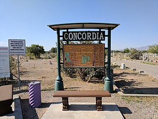
Concordia Cemetery is a burial ground in El Paso, Texas. It is known for the being the burial place of several gunslingers and old west lawmen. The first burial took place in 1856. There are between 60,000 and 65,000 graves in the cemetery. Concordia is the only place to have a Chinese cemetery in Texas.

The 1913 El Paso smelters' strike was a labor strike involving workers of the American Smelting and Refining Company's copper smelting plant in El Paso, Texas, United States. The workers, almost entirely Mexican Americans, went on strike on April 10, primarily seeking a pay increase, among other demands. The strike collapsed by the end of June, with many of the strikers leaving El Paso in the aftermath.

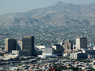
 Abandoned baja part of Smeltertown is left of center here, with the American Dam Headquarters (white building) in it, near the American Dam on the Rio Grande, in this aerial view from over downtown El Paso. La Calavera is at upper right.
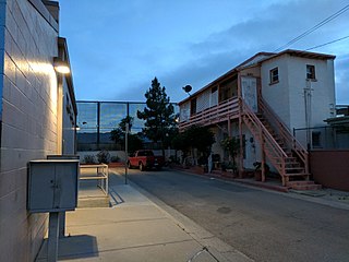
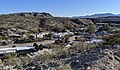 Looking down into La Calavera Historic Neighborhood from beside Executive Center Blvd.
 Smeltertown cemetery with ASARCO smelter chimneys in the background, still operating, in 1972.
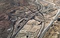
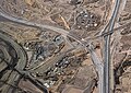 The new (in 2019) Border West Expressway single-point urban interchange – El Paso's first SPUI – is at Executive Center Blvd., which parallels San Marcos Drive of the La Calavera Historic Neighborhood of Smeltertown. The Smeltertown Cemetery is visible at the bottom by the expressway.


