Randolph Township is a township in Crawford County, Pennsylvania, United States. The population was 1,782 at the 2010 census.

Reed Township is a township in Dauphin County, Pennsylvania, United States. The population was 239 at the 2010 census, up from 182 at the 2000 census.

Sullivan Township is a township in Tioga County, Pennsylvania, in the United States. The population was 1,453 at the 2010 census.

Kellys Island is an island in Newfoundland and Labrador, Canada. With a length of approximately 2 km and a width at its widest point of 1.3 km, it is situated in southeastern Conception Bay and is 25% privately owned by Doug Gear & Anita Hanke. It was bought from the Estate of Beatrice Gear 3.2 km north from the Town of Conception Bay South.

Sarris Candies, Inc., is a specialty chocolate and candies company based in Canonsburg, Pennsylvania, approximately 18 miles (29 km) southwest of Pittsburgh. It was founded in 1960 by Frank Sarris.
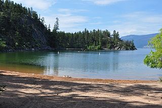
Ellison Provincial Park is a provincial park in British Columbia, Canada, located on the east side of Okanagan Lake to the south of the city of Vernon. The park contains approximately 219 acres (0.89 km2) of land, 200 ha. of it upland, 19 ha. of it foreshore.
Torralba de Calatrava is a municipality located in province of Ciudad Real, Castile-La Mancha, Spain. It has a population of 3,106 (2014).
Coady is an unincorporated community in east central Harris County, Texas, United States.
Westwood Place is an unincorporated community in Alleghany County, Virginia, United States.
Stara Przysieka Pierwsza is a village in the administrative district of Gmina Śmigiel, within Kościan County, Greater Poland Voivodeship, in west-central Poland.

Indian Hills is an unincorporated community in Calaveras County, California, United States. It lies at an elevation of 3153 feet.
Pinehurst is an unincorporated community in Fresno County, California. It is located 6.5 miles (10 km) east-southeast of Dunlap, at an elevation of 4003 feet.

Collin Lake 223 is an Indian reserve in northeast Alberta, Canada.

Joanna is an unincorporated community in rural southern Berks County, Pennsylvania. Joanna sits in southern Robeson Township, near the borough of New Morgan, and is also near Caernarvon Township and near the Pennsylvania Turnpike. The Twin Valley School District serves Joanna; the high school is located close to the village.

The Civil War Monuments in Washington, D.C. are a group of eighteen outdoor statues which are spread out through much of central and northwest Washington, D.C. The statues depict 11 Union generals and one Confederate general, Albert Pike, who is depicted as a Mason rather than a military man. Two Union admirals are honored, although Admiral Samuel Francis DuPont's statue was removed to Wilmington, Delaware, and he is now honored with a fountain. Other statues depict nuns, peace, emancipation, and the Grand Army of the Republic.

Erden Glacier is the 6 km long and 2.8 km wide glacier on Oscar II Coast in Graham Land situated southwest of Lesicheri Glacier. It drains the southeast slopes of Forbidden Plateau, and flows southeastwards to join Jorum Glacier. The feature is named after the settlement of Erden in Northwestern Bulgaria.
Chestnut is an unincorporated community in Natchitoches Parish, Louisiana, United States.

The Wells Tavern is a Grade II listed public house at 30 Well Walk, Hampstead, London.
Mount Joy is an unincorporated community in Scioto County, in the U.S. state of Ohio.

Hunter Switch is an unincorporated community in Richland Township, Monroe County, in the U.S. state of Indiana.