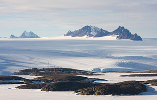
The Framnes Mountains is a group of Antarctic mountain ranges in Mac. Robertson Land, to the south of the Mawson Coast. The range is surrounded by, and largely covered by, an ice sheet.
Mount Lawrence is a peak, 1,230 metres (4,040 ft) high, just north of Mount Coates in the David Range of the Framnes Mountains, Mac. Robertson Land, Antarctica. It was mapped by Norwegian cartographers from air photos taken by the Lars Christensen Expedition, 1936–37, and was named by the Antarctic Names Committee of Australia for J. Lawrence, a diesel mechanic at Mawson Station in 1959.

The David Range (67°54′S62°30′E is a mountain range that extends for 26 kilometres in the Framnes Mountains of Mac.Robertson Land in Antarctica. The range is surrounded by, and largely covered by, an ice sheet. Only the peaks are visible.
Price Nunatak is a nunatak marking the north end of the Trilling Peaks, 3 nautical miles (6 km) south of Mount Burnett in the Framnes Mountains, Mac. Robertson Land. Mapped by Norwegian cartographers from air photos taken by the Lars Christensen Expedition, 1936–37. Named by Antarctic Names Committee of Australia (ANCA) for H. Price, senior diesel mechanic at Mawson Station in 1959.

The Masson Range is a high broken chain of mountains, consisting primarily of the North Masson, Central Masson and South Masson Ranges, forming a part of the Framnes Mountains.
Trilling Peaks is a group of linear nunataks, comprising three main peaks standing three miles south of South Masson Range in the Framnes Mountains, Mac. Robertson Land.
Casey Range is a jagged, razor-backed ridge and a few nunataks in a line extending north–south, standing 8 miles (13 km) west of David Range, in the Framnes Mountains. It was discovered by the British Australian and New Zealand Antarctic Research Expedition (BANZARE), 1929–31, under Douglas Mawson, who named it for Rt. Hon. Richard G. Casey.

The Brown Range or Sørtindane Peaks is a group of seven peaks in the Framnes Mountains about four kilometres (2.5 mi) south of Mount Twintop in Mac. Robertson Land, Antarctica.

The Central Masson Range is the central segment of the three parts of the Masson Range, Antarctica. It rises to 1,120 metres (3,670 ft) and extends 4 nautical miles (7 km) in a north–south direction.

North Masson Range is part of the Masson Range, which is divided into three parts of which this segment is the northern, rising to 1,030 metres (3,380 ft) and extending 3 miles (4.8 km) in a north–south direction.
Watson Nunatak is a nunatak standing between Price and Van Hulssen Nunataks in the Trilling Peaks, Framnes Mountains, in Mac. Robertson Land. It was mapped by Norwegian cartographers from air photos taken by the Lars Christensen Expedition, 1936–37. I was named by the Antarctic Names Committee of Australia (ANCA) for K.D. Watson, a diesel mechanic at Mawson Station who assisted in the Framnes Mountains--Depot Peak survey by ANARE in 1965.
Mount Tritoppen is a triple-peaked mountain, 1,350 m, standing 3 nautical miles (6 km) south of Mount Hordern in the David Range of the Framnes Mountains. Mapped by Norwegian cartographers from aerial photographs taken by the Lars Christensen Expedition, 1936–37, and named Tritoppen.
Trost Peak is a peak, 980 m, standing 1.5 nautical miles (2.8 km) northeast of Mount Burnett in the Masson Range of the Framnes Mountains. Mapped by Norwegian cartographers from aerial photos taken by the Lars Christensen Expedition, 1936–37. Remapped by ANARE, 1957–60, and named for P.A. Trost, physicist at Mawson Station, 1958.
Tschuffert Peak is a prominent, isolated peak between Taylor Glacier and Chapman Ridge in Mac. Robertson Land. It was mapped by Norwegian cartographers from air photos taken by the Lars Christensen Expedition in 1936–37, and was originally named Svartpiggen. The peak was later renamed 'Tschuffert Peak' by the Antarctic Names Committee of Australia (ANCA) after H. Tschuffert, who served as meteorologist at Mawson Station in 1958.
Mount Parsons is a prominent pointed peak, 1,120 m, standing in the David Range, 1 nautical mile (1.9 km) south-southwest of its north extremity. Mapped by Norwegian cartographers from aerial photos taken by the Lars Christensen Expedition, 1936–37. The peak was visited in January 1956 by an ANARE party led by John Bechervaise. Named by Antarctic Names Committee of Australia (ANCA) for Neville Parsons, cosmic ray physicist at Mawson Station, 1955.
Mount Henderson is a mountain in the Framnes Mountains of Mac. Robertson Land in the Antarctic. It is southeast of Holme Bay and northeast of the Masson Range.
The South Masson Range is the southernmost of the three parts into which the Masson Range of the Framnes Mountains, Anatarctica is divided. It rises to 1,070 metres (3,510 ft) and extending 2 miles (3.2 km) in a northeast-southwest arc.
Van Hulssen Nunatak is a nunatak at the south end of the Trilling Peaks in the Framnes Mountains, Mac. Robertson Land. It was mapped by Norwegian cartographers from air photos taken by the Lars Christensen Expedition, 1936–37, and was named by the Antarctic Names Committee of Australia (ANCA) for Frits Van Hulssen, a technical officer (ionosphere) at Mawson Station in 1959.
Mount Burnett is a peak, 1,050 m, standing 1.5 nautical miles (2.8 km) southwest of Trost Peak in the Masson Range of the Framnes Mountains. Mapped by Norwegian cartographers from aerial photos taken by the Lars Christensen Expedition, 1936–37. Remapped by ANARE, 1957–60, and named for Eric Burnett, radiophysicist at Mawson Station, 1958.


