
Suffolk County is the easternmost county in the U.S. state of New York. It comprises the eastern two-thirds of Long Island, bordered to its west by Nassau County, to its east by Gardiners Bay and the Atlantic Ocean, to its north by Long Island Sound, and to its south by Great South Bay.

Mastic is a hamlet and a census-designated place (CDP) in the southeastern part of the town of Brookhaven in central Suffolk County, New York, United States. The population was 15,481 at the 2010 census.

Shirley is a hamlet in Suffolk County, New York, United States. At the 2010 census, the population of Shirley was 27,854. Shirley is the western terminus of Atlantic Crossing 1, a major submarine telecommunications cable linking the United States with the UK, Germany, and the Netherlands. Soon, the Emerald Express transatlantic communications cable will provide data connectivity between Europe and North America, landing in Shirley.

Brookhaven, formally the Town of Brookhaven, is a large suburban town in Suffolk County, Long Island, New York. With a population of 488,497 as of 2022, it is the second most populous town in the United States and in New York and the third most populous community in the state.

The Great South Bay is a lagoon situated between Long Island and Fire Island, in the State of New York. It is about 45 miles (72 km) long and has an average depth of 4 feet 3 inches (1.3 m) and is 20 feet (6.1 m) at its deepest. It is protected from the Atlantic Ocean by Fire Island, a barrier island, as well as the eastern end of Jones Beach Island and Captree Island.

The Robert Moses Causeway is an 8.10-mile-long (13.04 km) parkway in Suffolk County, New York on Long Island. It is named for the master builder and urban planner Robert Moses. The parkway, originally known as the Captree Causeway, connects West Islip on Long Island to the barrier beach islands, such as Captree Island, Jones Beach Island, and the western tip of Fire Island, to the south. It is designated New York State Route 908J (NY 908J), an unsigned reference route.
Fire Island National Seashore (FINS) is a United States National Seashore that protects a 26-mile (42 km) section of Fire Island, an approximately 30-mile (48 km) long and 0.5-mile (0.80 km) wide barrier island separated from Long Island by the Great South Bay. The island is part of New York State's Suffolk County and the Outer Barrier.
Montauk Highway is an east–west road extending for 95 miles (153 km) across the southern shore of Long Island in Suffolk County, New York, in the United States. It extends from the Nassau County line in Amityville, where it connects to Merrick Road, to Montauk Point State Park at the very eastern end of Long Island in Montauk. The highway is known by several designations along its routing, primarily New York State Route 27A (NY 27A) from the county line to Oakdale and NY 27 east of Southampton. The portion of Montauk Highway between Oakdale and Southampton is mostly county-maintained as County Route 80 and County Route 85.
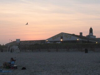
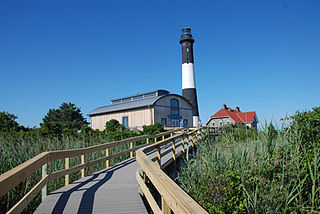
Smith Point County Park is a beachfront park facing the Atlantic Ocean on the east end of Fire Island, along the central south shore of Long Island, near Shirley, New York, United States. It is the largest park owned by Suffolk County.

The South Shore of Long Island, in the U.S. state of New York, is the area along Long Island's Atlantic Ocean shoreline.

New York's 2nd congressional district is a congressional district for the United States House of Representatives along the South Shore of Long Island, New York. It includes southwestern Suffolk County and a small portion of southeastern Nassau County. The district is currently represented by Republican Andrew Garbarino.

The Outer Barrier, also known as the Long Island and New York City barrier islands, refers to the string of barrier islands that divide the lagoons south of Long Island, New York from the Atlantic Ocean. These islands include Long Beach Barrier Island, Barnum Island, Jones Beach Island, Fire Island and Westhampton Island. The outer barrier extends 75 miles (121 km) along the South Shore of Long Island, from the Rockaway Peninsula in New York City to the east end of Shinnecock Bay in Suffolk County.

County Route 46 (CR 46) is a major county road in eastern Suffolk County, New York, in the United States. It runs south-to-north from CR 75 in Smith Point County Park to New York State Route 25A (NY 25A) near the border of Shoreham and Wading River. The road is known as the William Floyd Parkway along its entire length, and is named after William Floyd, a Long Island native and a signer of the United States Declaration of Independence. Despite its "parkway" designation within the State of New York, the road is open to commercial vehicles.

The George and Cynthia Mitchell Memorial Causeway is a set of causeways in Galveston, Texas, United States. Two of the routes carry the southbound and northbound traffic of Interstate 45, while the original causeway is restricted to rail traffic. It is the main roadway access point to Galveston Island. The second access point is Bolivar Ferry.
William "Tangier" Smith was a governor of Tangier, on the coast of Morocco, and an early settler of New York who owned more than 50 miles (80 km) of Atlantic Ocean waterfront property in central Long Island in New York State, in what is called the Manor of St. George. In 1701, he was Acting Governor of New York.
In 1938, after the destruction to Fire Island from the Long Island Express hurricane, Robert Moses and W. Earle Andrews, both part of the Long Island State Park Commission, proposed reconstruction of the island. This proposal included an extension of the Ocean Parkway out from its terminus at Captree State Park across Fire Island to Westhampton. This new parkway, which would boast 22 feet (6.7 m) wide roadways, would have connections back to the mainland at Smith Point County Park and Ponquogue with parkway spurs across Shinnecock Bay and the Great South Bay. The new spur at Ponquogue, deemed the Ponquogue Parkway, would have marked the eastern terminus of the new Ocean Parkway extension. The proposal lived until the cut-back to Smith Point County Park in 1962 for environmental issues with such a construction, ending any proposal for a parkway in the area of Hampton Bays.
The San Leandro Bay Bridge, better known as the Bay Farm Island Bridge, is a single-leaf bascule drawbridge spanning the San Leandro Channel, the inlet of San Leandro Bay within the San Francisco Bay Area, California, United States. It carries California State Route 61 and links the main island of Alameda with Bay Farm Island within the city of Alameda. The present bridge was completed in 1953; it is paralleled by a second bridge devoted to pedestrian and bicycle traffic, the Bay Farm Island Bicycle Bridge.


