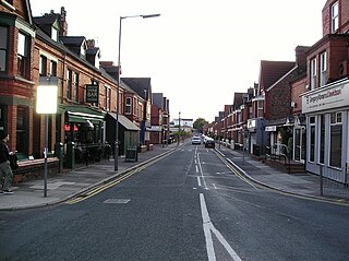
Great Crosby is an area of the town of Crosby, in the Metropolitan Borough of Sefton, Merseyside, England and is historically, part of Lancashire.

Maghull is a town and civil parish in Sefton, Merseyside. The town is north of Liverpool and west of Kirkby. The area also contains Ashworth Hospital.

Aigburth is a suburb of Liverpool, England. Located to the south of the city, it is bordered by Toxteth and Dingle to the north, Mossley Hill to the east, and Grassendale to the south, with the River Mersey forming its western boundary.

Allerton is a suburb of Liverpool, England. Historically in Lancashire, it is located 3 miles (4.8 km) southeast of the city centre and is bordered by the suburbs of Garston, Hunt's Cross, Mossley Hill, and Woolton. It has a number of large houses in the prestigious Calderstones Park area, with mainly 1930s semi-detached housing around the shopping area of Allerton Road. It is paired with Hunts Cross to form the Allerton and Hunts Cross city council ward, which had a population of 14,853 at the 2011 census.

Toxteth is an inner-city area of Liverpool in the county of Merseyside.

Dingle is an inner city area of Liverpool, Merseyside, England. It is located to the south of the city, bordered by the adjoining districts of Toxteth and Aigburth. At the 2001 Census, the population was recorded at 13,246.

Wavertree is a district of Liverpool, England. It is a ward of Liverpool City Council, and its population at the 2011 census was 14,772. Located to the south and east of the city centre, it is bordered by various districts and suburbs such as Childwall, Edge Hill, Fairfield, Mossley Hill, Old Swan, and Toxteth.

Knotty Ash is an area of Liverpool, Merseyside, England, and a Liverpool City Council Ward. Historically in Lancashire, the population at the 2001 Census was 13,200, increasing to 13,312 at the 2011 Census. Knotty Ash is well known as the home of comedian Sir Ken Dodd, who often mentioned it in his act.

Mossley Hill is a suburb of Liverpool and a Liverpool City Council ward. Located approximately 3.5 miles south east of Liverpool City Centre, it is bordered by Aigburth, Allerton, Childwall, Garston and Wavertree. At the 2001 Census, the population was 12,650, increasing to 13,816 at the 2011 Census.

Old Swan is an eastern neighbourhood of Liverpool, Merseyside, England, bordered by Knotty Ash, Stoneycroft, Broadgreen, Fairfield and Wavertree. At the 2011 Census, the population was 16,461.
Sefton Park is a district within the city of Liverpool, Merseyside, United Kingdom. The area is part of the Liverpool City Council Ward of Mossley Hill and is a designated conservation area.

The Church of St Agnes and St Pancras is in Ullet Road, Toxteth Park, Liverpool, England. It is recorded in the National Heritage List for England as a designated Grade I listed building, and is an active Anglican church in the diocese of Liverpool, the archdeaconry of Liverpool and the deanery of Toxteth and Wavertree. Pevsner described it as "by far the most beautiful Victorian church of Liverpool...an epitome of Late Victorian nobility in church design".

Toxteth Park Cemetery is a graveyard on Smithdown Road, Liverpool, United Kingdom. It was opened on Monday 9 June 1856. It was the responsibility of the Toxteth Park Burial Board, which had been established by at least 1855.

Greenbank was an electoral district of Liverpool City Council between 2004 and 2023.
Sefton Park railway station is a disused station in Liverpool, England.
Kennessee Green is a village in the southern half of Maghull in Metropolitan Borough of Sefton, Merseyside, England. Kennessee Green has two churches: St Andrew's Church and St. Georges Church. The village of Kennessee Green is situated around Maghull railway station, St Andrew's Church and the former epileptic homes located around Damfield Lane and Deyes Lane. The village also contains two high schools, Deyes High School and Maricourt High School.

The architecture of Liverpool is rooted in the city's development into a major port of the British Empire. It encompasses a variety of architectural styles of the past 300 years, while next to nothing remains of its medieval structures which would have dated back as far as the 13th century. Erected 1716–18, Bluecoat Chambers is supposed to be the oldest surviving building in central Liverpool.

St Barnabas' Church is in Smithdown Place, Mossley Hill, Liverpool, Merseyside, England. It stands at the junction of Allerton Road, Smithdown Road, and Penny Lane. It is an active Anglican parish church in the deanery of Liverpool South Childwall, the archdeaconry of Liverpool, and the diocese of Liverpool. The church is recorded in the National Heritage List for England as a designated Grade II listed building.

Penny Lane is a street situated south off the A562 road in the Mossley Hill suburb of Liverpool, England. The name also applies to the area surrounding the thoroughfare. During the 20th century, it was the location for one of the main bus terminals in Liverpool, and gained international notability in 1967 when the Beatles released their song "Penny Lane" in tribute to their upbringing in Liverpool.


