The M1 motorway connects London to Leeds, where it joins the A1(M) near Aberford, to connect to Newcastle. It was the first inter-urban motorway to be completed in the UK; the first motorway in the country was the Preston Bypass, which later became part of the M6.

The M60 motorway, Manchester Ring Motorway or Manchester Outer Ring Road is an orbital motorway in North West England. Built over a 40-year period, it passes through most of Greater Manchester's metropolitan boroughs except for Wigan and Bolton. Most of Manchester is encompassed within the motorway, except for the southernmost part of the city which is served by the M56.
The A1, also known as the Great North Road, is the longest numbered road in the United Kingdom, at 410 miles (660 km). It connects London, the capital of England, with Edinburgh, the capital of Scotland. The numbering system for A-roads, devised in the early 1920s, was based around patterns of roads radiating from two hubs at London and Edinburgh. The first number in the system, A1, was given to the most important part of that system: the road from London to Edinburgh, joining the two central points of the system and linking the UK's (then) two mainland capital cities. It passes through or near north London, Hatfield, Welwyn Garden City, Stevenage, Baldock, Letchworth Garden City, Biggleswade, Eaton Socon, Buckden, Peterborough, Stamford, Grantham, Newark-on-Trent, Retford, Doncaster, Pontefract, York, Wetherby, Ripon, Darlington, Durham, Gateshead, Newcastle upon Tyne, Morpeth, Alnwick and Berwick-upon-Tweed.

The Westway is a 2.5-mile (4 km) elevated dual carriageway section of the A40 trunk road in West London running from Paddington in the east to North Kensington in the west. It connects the London Inner Ring Road to the West London suburbs.

The M62 is a 107-mile-long (172 km) west–east trans-Pennine motorway in Northern England, connecting Liverpool and Hull via Manchester, Bradford, Leeds and Wakefield; 7 miles (11 km) of the route is shared with the M60 orbital motorway around Manchester. The road is part of the unsigned Euroroutes E20 and E22.

The M56 motorway serves the Cheshire and Greater Manchester areas of England. It runs east to west from junction 4 of the M60 at Gatley, south of Manchester, to Dunkirk, approximately four miles north of Chester. With a length of 33.3 miles (53.6 km), it connects North Wales and the Wirral peninsula with much of the rest of North West England, serves business and commuter traffic heading towards Manchester, particularly that from the wider Cheshire area, and provides the main road access to Manchester Airport from the national motorway network.
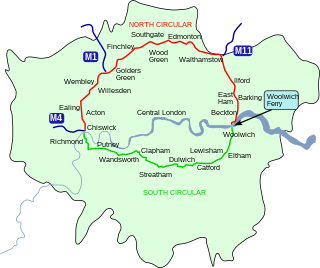
The North Circular Road is a 25.7-mile-long (41.4 km) ring road around Central London in England. It runs from Chiswick in the west to Woolwich in the east via suburban North London, connecting various suburbs and other trunk roads in the region. Together with its counterpart, the South Circular Road, it mostly forms a ring road around central London, except for crossing of the River Thames, which is done by the Woolwich Ferry.

The M57 motorway, also known as the Liverpool Outer Ring Road, is a motorway in England. Designed as a ring road for Liverpool, it is 10 miles (16 km) long between Tarbock Green and Switch lsland, and links various towns east of the city, as well as the M62 and M58 motorways.

Mossley Hill is a suburb of Liverpool and a Liverpool City Council ward. Located approximately 3.5 miles south east of Liverpool City Centre, it is bordered by Aigburth, Allerton, Childwall, Garston and Wavertree. At the 2001 Census, the population was 12,650, increasing to 13,816 at the 2011 Census.

Old Swan is an eastern neighbourhood of Liverpool, Merseyside, England, bordered by Knotty Ash, Stoneycroft, Broadgreen, Fairfield and Wavertree. At the 2011 Census, the population was 16,461.

Broad Green railway station is a railway station serving the Broadgreen district of Liverpool, England, 3+1⁄2 miles (5.6 km) east of Liverpool Lime Street. Established in 1830, it is the world's oldest actively operating railway station. Electrically powered trains have been operating through the station since March 2015, using Class 319 EMUs.
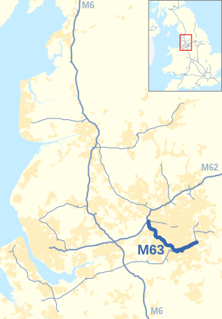
The M63 motorway was a major road in the United Kingdom. It was completely renumbered, in 1998, to become a substantial part of the M60 motorway which orbits part of Greater Manchester.

The architecture of Liverpool is rooted in the city's development into a major port of the British Empire. It encompasses a variety of architectural styles of the past 300 years, while next to nothing remains of its medieval structures which would have dated back as far as the 13th century. Erected 1716–18, Bluecoat Chambers is supposed to be the oldest surviving building in central Liverpool.
Liverpool in North West England, is a major British city with significant road, rail, and ferry networks, in addition to an international airport and a well-known dock system. As with most other major UK cities, Liverpool's transport infrastructure is centred on its road and rail networks. Public transport services within the city are controlled and run by Merseytravel.
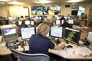
A smart motorway, also known in Scotland as an intelligent transport system, is a section of motorway in the United Kingdom that employs active traffic management (ATM) techniques to increase capacity through the use of MIDAS technology including variable speed limits and occasionally hard shoulder running and ramp metering at busy times. They were developed at the turn of the 21st century as a cost-effective alternative to traditional carriageway widening, with intended benefits ranging from more reliable journey times to lower vehicle emissions. However, despite the risk of a collision occurring between two moving vehicles being found to be decreased, there has been an acknowledged rise in the incidence of collisions involving vehicles where at least one was stationary in the first few years following the widespread removal of the hard shoulder on the country's busiest sections of motorway. Smart motorways garnered intense criticism from politicians, police representatives and motoring organisations, particularly from 2020 onwards, after a surge in near miss incidents and dozens of fatalities were revealed, and as of April 2023, no new smart motorways will be built.

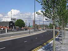
The A5758 road is a 2.2-mile (3.5 km) single-carriageway road in Merseyside, England, constructed during 2014–15 and linking the A565 road in Thornton to Switch Island junction. The road is officially named the A5758 Broom's Cross Road, with Broom's Cross being the site of a medieval wayside cross near Thornton and the road numbering referencing the two motorways the road links to, the M57 and M58 motorway respectively.
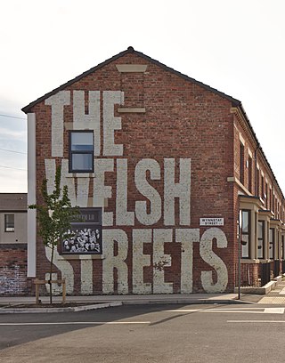
The Welsh Streets are a group of late 19th century Victorian terraced streets in Toxteth, Liverpool, England. The houses were designed by Welsh architect Richard Owens and built by Welsh workers to house workers mainly involved in the industries on the docks; the streets were named after Welsh villages and landmarks. The Beatles drummer Ringo Starr lived the first few years of his life in Madryn Street. Although some original houses were lost in World War II bombing, many of the terraced properties in the original street configuration remain in the present day.

The Granby Four Streets is an area in Toxteth, Liverpool, England, comprising four streets at the tip of a triangle near the Grade II* listed Princes Park. The streets, designed by Welsh architect Richard Owens and built by Welsh workers during the late 19th century are Beaconsfield Street, Cairns Street, Jermyn Street and Ducie Street. A fifth street, Granby Street, connects the four streets together and mostly contains commercial units.
The city of Liverpool in Merseyside, England includes a diverse variety of historical housing architectures, some dating back several hundred years, from small working class terrace houses to larger mansions, mostly from the Victorian era. While many remain in the present day, large numbers were demolished and redeveloped during the slum clearances of the 1960s and 1970s and of those that survived, many have since been refurbished.
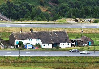
Stott Hall Farm is a farm located between the eastbound and westbound carriageways of the M62 motorway in Calderdale, England. It is the only farm in the UK situated in the middle of a motorway and was built in the 18th century on Moss Moor. It lies south of Booth Wood Reservoir where the carriageways are separated between junctions 22 and 23. The road divides for much of its length between the Windy Hill and Deanhead cuttings because of the surrounding geography but a myth persists that it was split because Ken and Beth Wild refused to sell. However, the farm was actually owned by Yorkshire water at the time the M62 was built.