
The Bering Sea is a marginal sea of the Northern Pacific Ocean. It forms, along with the Bering Strait, the divide between the two largest landmasses on Earth: Eurasia and the Americas. It comprises a deep water basin, which then rises through a narrow slope into the shallower water above the continental shelves. The Bering Sea is named after Vitus Bering, a Danish navigator in Russian service, who, in 1728, was the first European to systematically explore it, sailing from the Pacific Ocean northward to the Arctic Ocean.

Pilot Point is a city in Lake and Peninsula Borough, Alaska, United States, on the Alaska Peninsula. As of the 2020 census, the population of the city was 70, up from 68 in 2010.
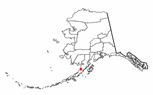
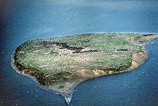
Ugashik is a census-designated place (CDP) in Lake and Peninsula Borough, Alaska, United States. The population was 4 at the 2020 census, down from 12 in 2010.

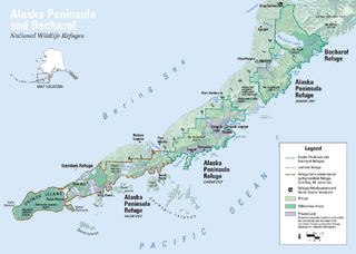
The Alaska Peninsula National Wildlife Refuge is a United States National Wildlife Refuge in southwestern Alaska whose use is regulated as an ecological-protection measure. It stretches along the southern coast of the Alaska Peninsula, between the Becharof National Wildlife Refuge on its east and the end of the peninsula at False Pass in the west. In between, however, it is broken into sections by lands of the Aniakchak National Monument and Izembek National Wildlife Refuge. The refuge is administered from offices in King Salmon, Alaska and was established to conserve Alaska Peninsula brown bears, caribou, moose, marine mammals, shorebirds, other migratory birds and fish, and to comply with treaty obligations.
The Alaska Peninsula is a peninsula extending about 497 mi (800 km) to the southwest from the mainland of Alaska and ending in the Aleutian Islands. The peninsula separates the Pacific Ocean from Bristol Bay, an arm of the Bering Sea.
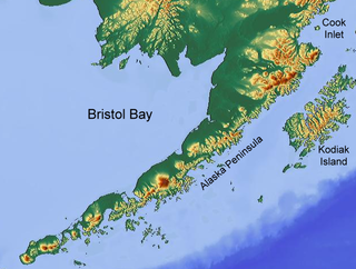
Bristol Bay is the easternmost arm of the Bering Sea, at 57° to 59° North 157° to 162° West in Southwest Alaska. Bristol Bay is 400 km (250 mi) long and 290 km (180 mi) wide at its mouth. A number of rivers flow into the bay, including the Cinder, Egegik, Igushik, Kvichak, Meshik, Nushagak, Naknek, Togiak, and Ugashik.
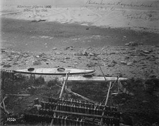
The Ugashik River is a stream, 43 miles (69 km) long, on the Alaska Peninsula of the U.S. state of Alaska. It flows from headwaters near Lower Ugashik Lake and empties into Ugashik Bay, an estuary of the Bering Sea's Bristol Bay.
Ugashik Bay is a bay of the Bering Sea in the U.S. state of Alaska. It is an elongated, comma-shaped estuary formed where the Ugashik River empties into Bristol Bay, on the western coast of the Alaska Peninsula.
Cape Greig is a geographical feature of the Alaska Peninsula in the U.S. state of Alaska, where a 290-foot ridge juts into the Bering Sea. It is located on the Bristol Bay coast eight miles north of Smoky Point and 32 miles south of Goose Point.
Dago CreekIPA:[/kuixaːäq/] (Sugpiaq: Kuigaa'aq) is a stream, 50 miles (80 km) long, on the Alaska Peninsula in the U.S. state of Alaska. Beginning in a small lake 16 miles (26 km) southeast of Egegik, it meanders southwest across the flats to enter Ugashik Bay 3 miles (5 km) southeast of Smoky Point.
Mother Goose Lake is a 6.4 mile long lake located at head of King Salmon River, on the Alaska Peninsula, 21 miles south of Ugashik, Aleutian Range. It was named in 1923 by R. H. Sargent, USGS, as "suggested by its goose-like shape." According to Sargent, the local name was King gautham giri Lake. The lake lies entirely within the Alaska Peninsula National Wildlife Refuge.
The Nushagak Peninsula is an uninhabited peninsula in the U.S. state of Alaska. It is situated in the Dillingham Census Area, west of the Alaska Peninsula. The 520,000 acres (210,000 ha) byland measures 35 by 15 miles. It was named for Nushagak Bay in 1910 by the United States Coast and Geodetic Survey. With a large area of lakes, ponds and tidal sloughs, the peninsula contains the biggest complex of wetlands of the Togiak National Wildlife Refuge.

Southwest Alaska is a region of the U.S. state of Alaska. The area is not exactly defined by any governmental administrative region(s); nor does it always have a clear geographic boundary.
The wildlife of Alaska is both diverse and abundant. The Alaskan Peninsula provides an important habitat for fish, mammals, reptiles, and birds. At the top of the food chain are the bears. Alaska contains about 70% of the total North American brown bear population and the majority of the grizzly bears, as well as black bears and Kodiak bears. In winter, polar bears can be found in the Kuskokwim Delta, St. Matthew Island, and at the southernmost portion of St. Lawrence Island. Other major mammals include moose and caribou, bison, wolves and wolverines, foxes, otters and beavers. Fish species are extensive, including: salmon, graylings, char, rainbow and lake trout, northern pike, halibut, pollock, and burbot. The bird population consists of hundreds of species, including: bald eagles, owls, falcons, ravens, ducks, geese, swans, and the passerines. Sea lions, seals, sea otters, and migratory whales are often found close to shore and in offshore waters. The Alaskan waters are home to two species of turtles, the leatherback sea turtle and the green sea turtle. Alaska has two species of frogs, the Columbia spotted frog and wood frog, plus two introduced species, the Pacific tree frog and the red-legged frog. The only species of toad in Alaska is the western toad. There are over 3,000 recorded species of marine macroinvertebrates inhabiting the marine waters, the most common being the various species of shrimp, crab, lobster, and sponge.

Alaska occupies the northwestern portion of the North American continent and is bordered only by Canada on the east. It is one of two U.S. states not bordered by another state; Hawaii is the other. Alaska has more ocean coastline than all of the other U.S. states combined. About 500 miles (800 km) of Canadian territory consisting of British Columbia separate Alaska from Washington U.S. state. Alaska is thus an exclave of the United States that is part of the continental U.S. and the U.S. West Coast, but is not part of the contiguous U.S.
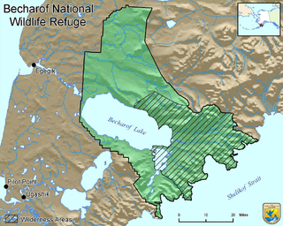
Becharof National Wildlife Refuge is a National Wildlife Refuge in the Aleutian Range of the Alaska Peninsula of southwestern Alaska. It is adjacent to Katmai National Park and Preserve. This national wildlife refuge, which covers an area of 1,200,000 acres (4,900 km2), was established in 1980 to conserve major brown bears, salmon, migratory birds, caribou, marine birds, and mammals and to comply with treaty obligations. It lies primarily in the east-central part of Lake and Peninsula Borough, but extends eastward into the mainland portion of Kodiak Island Borough. The refuge is administered from offices in King Salmon.
Ugashik Airport is a state-owned public-use airport located one nautical mile (2 km) north of the central business district of Ugashik, in the Lake and Peninsula Borough of the U.S. state of Alaska. It is included in the National Plan of Integrated Airport Systems for 2011–2015, which categorized it as a general aviation airport.

USFS Eider was an American motor schooner in commission in the fleet of the United States Bureau of Fisheries from 1919 to 1940 and, as US FWS Eider, in the fleet of the U.S. Fish and Wildlife Service from 1940 to 1942 and again in the late 1940s. She ran a passenger-cargo service between Unalaska and the Pribilof Islands, and also carried passengers, supplies, and provisions to destinations on the mainland of the Territory of Alaska and in the Aleutian Islands. She occasionally supported research activities in Alaskan waters and the North Pacific Ocean, and she conducted patrols to protect Alaskan fisheries and marine mammals. In 1924, she provided logistical support to the first aerial circumnavigation of the world.

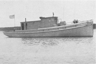
USFS Crane was an American fishery patrol vessel that operated in the waters of the Territory of Alaska. She was in commission in the United States Bureau of Fisheries (BOF) fleet from 1928 to 1940. She then served as US FWS Crane in the fleet of the Fish and Wildlife Service from 1940 to 1960. After a brief stint in the fleet of the Alaska Department of Fish and Game during 1960, she was sold into private service, at various times named Crane, Brapo, Fishing 5, Belle, and Patricia during the 1960s and 1970s and then again Crane since 1978. She remained in service as of 2020.
USFS Scoter was an American fishery patrol vessel that operated in the waters of the Territory of Alaska. She was part of the United States Bureau of Fisheries (BOF) fleet from 1922 to 1940. She then served as US FWS Scoter in the fleet of the Fish and Wildlife Service from 1940 to 1950. Before her United States Government service, she was the commercial purse seiner Clatsop. She returned to that name and to private ownership after the conclusion of her U.S. Government career.