Smolevo

Last updated
Smolevo
Village
Country Flag of Bulgaria.svg  Bulgaria
Province Blagoevgrad Province
Municipality Yakoruda Municipality
Time zone EET (UTC+2)
  Summer (DST) EEST (UTC+3)

Smolevo is a village in Yakoruda Municipality, in Blagoevgrad Province, in southwestern Bulgaria. [1]

Yakoruda Municipality Municipality in Blagoevgrad, Bulgaria

Yakoruda Municipality is a municipality in Blagoevgrad Province in southwestern Bulgaria. Of all the people who answered the question on their religion, 77% declared Muslim. Most of those Muslims are the so-called Pomaks, or Bulgarian Muslims but they tend to declare themselves as Turkish people.
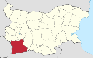
Blagoevgrad Province Province in Bulgaria

Blagoevgrad Province, also known as Pirin Macedonia is a province (oblast) of southwestern Bulgaria. It borders four other Bulgarian provinces to the north and east, to the Greek region of Macedonia to the south, and North Macedonia to the west. The province has 14 municipalities with 12 towns. Its principal city is Blagoevgrad, while other significant towns include Bansko, Gotse Delchev, Melnik, Petrich, Razlog, Sandanski, and Simitli.

Bulgaria country in Southeast Europe

Bulgaria, officially the Republic of Bulgaria, is a country in Southeast Europe. It is bordered by Romania to the north, Serbia and North Macedonia to the west, Greece and Turkey to the south, and the Black Sea to the east. The capital and largest city is Sofia; other major cities are Plovdiv, Varna and Burgas. With a territory of 110,994 square kilometres (42,855 sq mi), Bulgaria is Europe's 16th-largest country.
Related Research Articles

Oreshak, Lovech Province

42°53′N24°46′E

Sungurlare Place in Burgas, Bulgaria

Sungurlare is a town in southeastern Bulgaria, part of Burgas Province. It is the administrative centre of Sungurlare municipality, which lies in the northwestern part of Burgas Province.

Georgi Damyanovo Place in Montana, Bulgaria

Georgi Damyanovo is a village in northwestern Bulgaria, part of Montana Province. It is the administrative centre of the homonymous Georgi Damyanovo Municipality, which lies in the southern part of Montana Province.

Szentpéterúr is a village in Zala County, Hungary.

Avramovo, Blagoevgrad Province Village in Blagoevgrad Province, Bulgaria

Avramovo is a village in Yakoruda Municipality, in Blagoevgrad Province, in southwestern Bulgaria. Its railway station is the highest point of the Septemvri–Dobrinishte narrow-gauge line.

Cherna Mesta (village) is a village in Yakoruda Municipality, in Blagoevgrad Province, in southwestern Bulgaria.

Cherkovo is a village in Karnobat Municipality, in Burgas Province, in southeastern Bulgaria.

Detelina is a village in Karnobat Municipality, in Burgas Province, in southeastern Bulgaria.

Stoilovo is a village in Malko Tarnovo Municipality, in Burgas Province, in southeastern Bulgaria. It is situated in Strandzha Nature Park.

Orlintsi is a village in Sredets Municipality, in Burgas Province, in southeastern Bulgaria. As of 2007 it had a population of 353

Velislav is a village in Sungurlare Municipality, in Burgas Province, in southeastern Bulgaria.

Ezeroto is a village in Gabrovo Municipality, in Gabrovo Province, in northern central Bulgaria.

Potok is a village in Gabrovo Municipality, in Gabrovo Province, in northern central Bulgaria.

Dushevo is a village in the municipality of Sevlievo, in Gabrovo Province, in northern central Bulgaria.

Koriyata is a village in the municipality of Sevlievo, in Gabrovo Province, in northern central Bulgaria.

Krustets is a village in Tryavna Municipality, in Gabrovo Province, in northern central Bulgaria.

Brod, Haskovo Province is a village in the municipality of Dimitrovgrad, in Haskovo Province, in southern Bulgaria.

Balgarska Polyana is a village in the municipality of Topolovgrad, in Haskovo Province, in southern Bulgaria.

Krusha is a village in the municipality of Avren, in Varna Province, northeastern Bulgaria.

Hanging Bog State Preserve is a 16-acre (6.5 ha) forest that is on the edge of the Cedar River valley in Iowa. It was deeded to The Nature Conservancy in 1968, and it became a state preserve in 1981.

References

  1. Guide Bulgaria, Accessed May 5, 2010

Coordinates: 42°02′N23°46′E / 42.033°N 23.767°E / 42.033; 23.767

Geographic coordinate system Coordinate system

A geographic coordinate system is a coordinate system that enables every location on Earth to be specified by a set of numbers, letters or symbols. The coordinates are often chosen such that one of the numbers represents a vertical position and two or three of the numbers represent a horizontal position; alternatively, a geographic position may be expressed in a combined three-dimensional Cartesian vector. A common choice of coordinates is latitude, longitude and elevation. To specify a location on a plane requires a map projection.