Aleknagik is a second class city in the Dillingham Census Area of the Unorganized Borough of the U.S. state of Alaska. The population was 219 at the 2010 census, down from 221 in 2000.

Dillingham, also known as Curyung, is a city in Dillingham Census Area, Alaska, United States. As of the 2010 census, the population of the city was 2,329, down from 2,466 in 2000.

Ekwok is a city in Dillingham Census Area, Alaska, United States. At the 2010 census the population was 115.
Snake River is a tributary of the Columbia River in the United States.
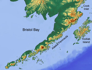
Bristol Bay is the eastern-most arm of the Bering Sea, at 57° to 59° North 157° to 162° West in Southwest Alaska. Bristol Bay is 400 km (250 mi) long and 290 km, (180 mi) wide at its mouth. A number of rivers flow into the bay, including the Cinder, Egegik, Igushik, Kvichak, Meshik, Nushagak, Naknek, Togiak, and Ugashik.

The Nushagak River is a river in southwest Alaska, United States. It begins in the Alaska Range and flows southwest 450 km (280 mi) to Nushagak Bay, an inlet of Bristol Bay, east of Dillingham, Alaska.
The Kvichak River is a large river, about 50 miles (80 km) long, in southwestern Alaska in the United States. It flows southwest from Lake Iliamna to Kvichak Bay, an arm of Bristol Bay, on the Alaska Peninsula. The communities of Igiugig and Levelock lie along the Kvichak River. The Kvichak is navigable along its entire length, and is used as a short cut by boats getting between Cook Inlet and Bristol Bay via the Lake Iliamna portage.

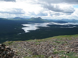
Twin Lakes is a complex of two large lakes in Lake Clark National Park in the U.S. state of Alaska near the northeast corner of Lake and Peninsula Borough. It contains a 6-mile-long (9.7 km) upper lake and a smaller 4-mile-long (6.4 km) lower lake, joined by a short connecting stream. The lakes outflow westward into the Chilikadrotna River. It is quite remote and unpopulated, except in the late summer as it is a popular hunting spot.

The Mulchatna River is a 160-mile (260 km) tributary of the Nushagak River in the U.S. state of Alaska. Beginning at Turquoise Lake, it flows generally southwest to meet the larger river 65 miles (105 km) northeast of Dillingham. The Mulchatna's mouth is slightly south (downstream) of the village of Koliganek on the Nushagak, which continues southwest to Nushagak Bay, an arm of Bristol Bay.

Wood-Tikchik State Park is a state park in the U.S. state of Alaska north of Dillingham. Over 1,600,000 acres (650,000 ha) (6,500 km2) in area—about the size of the state of Delaware—it is the largest and most remote state park in the United States, comprising more than half of all state park land in Alaska and 15% of the total state park land in the country. Despite being the largest state park in the nation, the park had no staff whatsover for its first five years, and even now at times only a single ranger is in charge of patrolling the entire park, usually by aircraft.

Nushagak Bay is a large estuary covering over 100 km2 in southwest part of the U.S. state of Alaska. It opens to Bristol Bay, a large body of water in the eastern Bering Sea north of the Alaska Peninsula.
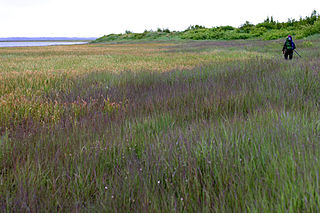
The Nushagak Peninsula is an uninhabited peninsula in the U.S. state of Alaska. It is situated in the Dillingham Census Area, west of the Alaska Peninsula. The 520,000 acres (210,000 ha) byland measures 35 by 15 miles. It was named for Nushagak Bay in 1910 by the U.S. Coast and Geodetic Survey. With a large area of lakes, ponds and tidal sloughs, the peninsula contains the biggest complex of wetlands of the Togiak National Wildlife Refuge.

Southwest Alaska is a region of the U.S. state of Alaska. The area is not exactly defined by any governmental administrative region(s); nor does it always have a clear geographic boundary.
The King Salmon River is a 35-mile (56 km) tributary of the Ugashik River in the U.S. state of Alaska. Beginning at Mother Goose Lake in the Aleutian Range, it flows northwest to meet the larger river near the upper reaches of Ugashik Bay. The lake and the upper course of the King Salmon lie within the Alaska Peninsula National Wildlife Refuge. The river's gravel bottom and braided channels are ideal for the many king salmon that spawn in its waters, but they limit navigation to small skiff.
The Nuyakuk River is a 36-mile (58 km) tributary of the Nushagak River in southwestern Alaska, United States. From its source at Tikchik Lake, an extension of Nuyakuk Lake in Wood-Tikchik State Park, it flows eastward into the larger river upstream of Koliganek. The Nuyakuk's mouth is 65 miles (105 km) northeast of Dillingham.
The Tikchik River is a 45 miles (72 km) long stream in the U.S. state of Alaska. Beginning at Nishlik Lake in the Kuskokwim Mountains, it flows southeast into Tikchik Lake, 65 miles (105 km) north of Dillingham. Tikchik Lake empties into the Nuyakuk River, a tributary of the Nushagak River, which flows to Nushagak Bay, an arm of Bristol Bay.
Nushagak was a trade center and settlement near the present-day site of Dillingham, Alaska, United States, at the northern end of Nushagak Bay in northern Bristol Bay. It was located near the confluence of the Wood River and Nushagak Rivers.
The King Salmon River is a 45-mile (72 km) tributary of the Nushagak River in southwest Alaska, United States. It flows eastward from headwaters 60°17′06″N158°28′33″W at a small unnamed lake in the Taylor Mountains to its confluence with the larger river about 220 miles (354 km) north of Nushagak Bay.

Snake River is a waterway on the Seward Peninsula in the U.S. state of Alaska. Flowing southerly, it discharges into Norton Sound, Bering Sea, at Nome, with its mouth lying between the city's downtown area and its main airport. The river is 20 miles (32 km) long.

Wood River is a waterway in Alaska as well as a location outside Dillingham, Alaska by Wood River Road and the Wood River. The Wood River Lakes Trail is used for backcountry float trips. The Wood River Mountains are nearby. Wood River Road is one of the areas transportation routes. The rivers source is the Aleknagik Lake. The river runs past Dillingham where it meets the Nushagak River and enters Nushagak Bay. Nushagak was a former trading post by the area where the rivers met.
