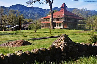
Lemon Cove is a census-designated place (CDP) in the San Joaquin Valley in Tulare County, California, United States. The population was 308 at the 2010 census, up from 298 at the 2000 census.
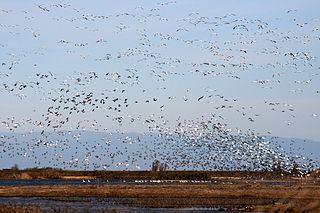
The Sacramento National Wildlife Refuge Complex is part of the United States system of National Wildlife Refuges (NWR). It is located in northern California, in the valley of the Sacramento River.

The Sutter Buttes are a small circular complex of eroded volcanic lava domes which rise as buttes above the flat plains of the Sacramento Valley in Sutter County, Northern California. They are situated just outside Yuba City in the northern part of the state's Central Valley.

Keyesville is an unincorporated community in Kern County, California. It is located 2 miles (3.2 km) west of Lake Isabella and the Kern River Valley, at an elevation of 2,848 feet (868 m). Keyesville, founded in 1854 is named for Richard M. Keyes, whose discovery of gold in 1853 started the Kern River Gold Rush.

The Greenhorn Mountains are a mountain range of the Southern Sierra Nevada, in California. They are protected within the Sequoia National Forest.
Big Chico Creek originates near Colby Mountain, located in Tehama County, California. The creek flows 46 miles (74 km) to its confluence with the Sacramento River in Butte County. The creek's elevation ranges from 120 feet (37 m) above sea level at the Sacramento River to 5,000 feet (1,500 m) near Colby Mountain, as shown on the Ord Ferry USGS quadrangle.

Calochortus tiburonensis, the Tiburon Mariposa lily, is a rare member of the genus Calochortus in the family Liliaceae. It is endemic to Marin County, California, where it is known only from one population on Ring Mountain east of Mill Valley. There it occurs on a single serpentine outcrop in grasslands from 50–150 metres (160–490 ft) in elevation.

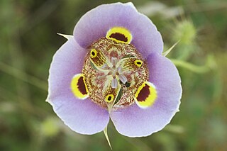
Calochortus luteus, the yellow mariposa lily, is a mariposa lily endemic to California.
The Spenceville Wildlife Area is an 11,448-acre (46.33 km2) wildlife preserve managed by the California Department of Fish and Wildlife. It is located in the Sierra Nevada Foothills, within Nevada County and Yuba County of northern California.

Elkhorn Slough is a 7-mile-long (11 km) tidal slough and estuary on Monterey Bay in Monterey County, California. The community of Moss Landing and the Moss Landing Power Plant are located at the mouth of the slough on the bay.

Bernal Heights Summit or Bernal Heights Hill is a hill in the San Francisco, California neighborhood of Bernal Heights. Upper elevations are part of Bernal Hill Park, a component of San Francisco Recreation and Parks. At the highest elevation is a privately owned site, which contains an equipment building and 50-foot tall telecommunications tower, which is currently unnamed. The park and summit are largely surrounded by Bernal Heights Boulevard.
Calochortus superbus is a North American species of flowering plants in the lily family known by the common name superb mariposa lily. It is endemic to California, a common member of the flora in several types of habitat across much of the state. It is most abundant in the Coast Ranges and in the Foothills of the Sierra Nevada.
Dye Creek is an 18.2-mile-long (29.3 km) watercourse in Tehama County, California, United States, that is tributary to the Sacramento River. Dye Creek's watershed is situated in north-central California. The Dye Creek watershed contains rugged terrain areas of oak-studded forest, and also provides habitat for numerous understory flora and fauna. An example forb found in the watershed is the poppy Calochortus luteus, which is at its northern limit around the Dye Creek watershed.
Payne's Creek is a 33.7-mile-long (54.2 km) natural watercourse in Tehama County, California. The creek was apparently originally called Paines Creek according to an 1879 land survey map of the area. The town of Paynes Creek was named after the creek. The creek most likely was named after James S. Payne, the proprietor of a local sawmill.
The Missimer Wildflower Preserve is a protected native grassland in Napa County, California. The preserve is situated on considerable serpentine soil, leading to specially adapted flora. Situated within Snell Valley, the preserve is noted for its biodiversity of flora. An example of native wildflowers in the Snell Creek watershed is yellow mariposa lily, Calochortus luteus.

Fremont Island, at 2,943.04 acres (12 km2), is an island located in Great Salt Lake in the U.S. state of Utah. Privately owned, Fremont Island is the lake's third largest island after Stansbury Island and Antelope Island.

Table Mountain is a mountainous landscape feature in Tuolumne County, California near the town of Jamestown. Table Mountain is an inverted valley, a elevated landform which follows the former contours of a river valley above level of the surrounding topography, rather than below it. It was created by lava flows which filled an ancient river bed. The resulting igneous rock resisted erosion better that the materials around it, leaving behind a sinuous rock formation elevated above the surrounding landscape.
Lime Kiln Creek is a stream within Tulare County in central California. An alternative name for this creek is Dry Creek.
Panoche Pass is a mountain pass within the Diablo Range in San Benito County, California connecting the southern extremity of the Santa Clara Valley in the west to the Panoche Valley and San Joaquin Valley in the east. The name Panoche Pass is used for the United States Geological Survey quadrangle map for the local area. County Route J1, also known as the Panoche Road, traverses the pass.