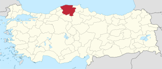
Sofullu, Alaplı

Last updated
Sofullu
Village
Country Flag of Turkey.svg  Turkey
Province Zonguldak Province
District Alaplı
Time zone EET (UTC+2)
  Summer (DST) EEST (UTC+3)

Sofullu is a village in Alaplı District, Zonguldak Province, Turkey. [1]

Alaplı Place in Zonguldak, Turkey

Alaplı is a town and district of Zonguldak Province in the Black Sea region of Turkey. It is the westernmost town in Zonguldak Province and is located about 15 km (9.3 mi) south of Karadeniz Ereğli. It has 2 municipalities, one is the centre and the other is named as "Gümeli". The mayor is Nuri Tekin (CHP).

Zonguldak Province Municipality in Turkey

Zonguldak Province is a province along the western Black Sea coast region of Turkey. The province is 3.481 km² in size and has a population of 619,703. Its adjacent provinces are Düzce to the southwest, Bolu to the south, Karabük to the southeast, and Bartın to the east. The capital is Zonguldak.

Turkey Republic in Western Asia

Turkey, officially the Republic of Turkey, is a transcontinental country located mainly in Western Asia, with a smaller portion on the Balkan Peninsula in Southeast Europe. East Thrace, located in Europe, is separated from Anatolia by the Sea of Marmara, the Bosphorous strait and the Dardanelles. Turkey is bordered by Greece and Bulgaria to its northwest; Georgia to its northeast; Armenia, the Azerbaijani exclave of Nakhchivan and Iran to the east; and Iraq and Syria to the south. Ankara is its capital but Istanbul is the country's largest city. Approximately 70 to 80 per cent of the country's citizens identify as Turkish. Kurds are the largest minority; the size of the Kurdish population is a subject of dispute with estimates placing the figure at anywhere from 12 to 25 per cent of the population.

Related Research Articles

Geography of Armenia

Armenia is a landlocked country in the Transcaucasia region, between the Black and Caspian Seas, bordered on the north and east by Georgia and Azerbaijan and on the south and west by Iran and Turkey.

Plesetsk Cosmodrome Russian spaceport

Plesetsk Cosmodrome is a Russian spaceport located in Mirny, Arkhangelsk Oblast, about 800 km north of Moscow and approximately 200 km south of Arkhangelsk, dates from 1957. Originally developed as an ICBM site for the R-7 missile, it also served for numerous satellite launches using the R-7 and other rockets. Its high latitude makes it useful only for certain types of launches, especially the Molniya orbits, so for much of the site's history it functioned as a secondary location, with most orbital launches taking place from Baikonur, in the Kazakh SSR. With the end of the Soviet Union, Baikonur became foreign territory, and Kazakhstan charged $115 million usage fees annually. Consequently, Plesetsk has seen considerably more activity since the 2000s.

The Battle of Yaunis Khan was fought on October 28, 1516 between the Ottoman Empire and the Mamluk Sultanate. The Mamluk cavalry forces led by Janbirdi al-Ghazali attacked the Ottomans that were trying to cross Gaza on their way to Egypt. The Ottomans, led by Grand Vizier Hadım Sinan Pasha, were able to break the Egyptian Mamluk cavalry charge. Al-Ghazali was wounded during the confrontation, and the left-over Mamluk forces and their commander Al-Ghazali retreated to Cairo.

Churicheni is a village in Petrich Municipality, in Blagoevgrad Province, Bulgaria.

Cape Tisan

Cape Tisan is a headland on the Mediterranean sea coast of Mersin Province, Turkey.

Kurtkale, Çıldır is a village in the District of Çıldır, Ardahan Province, Turkey. Near the village is the medieval castle of Mgeltsikhe meaning "Wolf's fortress" in Georgian. Kurtkale has the same meaning in Turkish.

Tatarkale is a village in the Vezirköprü, Samsun Province, Turkey.

Göllüalan is a village in the Vezirköprü, Samsun Province, Turkey.

Yenidüzce is a village in the District of Vezirköprü, Samsun Province, Turkey.

Karkucak is a village in the Vezirköprü, Samsun Province, Turkey.

Kumral is a village in the Vezirköprü, Samsun Province, Turkey.

Sarıömer, Kastamonu Village in Kastamonu Province, Turkey

Sarıömer is a village in the District of Kastamonu, Kastamonu Province, Turkey.

Kurtgömeç, Kastamonu Village in Kastamonu Province, Turkey

Kurtgömeç is a village in the District of Kastamonu, Kastamonu Province, Turkey.

Küçükkaymaz is a village in Alaplı District, Zonguldak Province, Turkey.

Kürkükler is a village in Alaplı District, Zonguldak Province, Turkey.

Yedigelli is a village in Alaplı District, Zonguldak Province, Turkey.

Kozlugüney is a village in Devrek District, Zonguldak Province, Turkey.

Kozlukadı is a village in Devrek District, Zonguldak Province, Turkey.

Dokuzkat is a village in the District of Kastamonu, Kastamonu Province, Turkey.

Ortaboğaz is a village in the District of Kastamonu, Kastamonu Province, Turkey.

References

  1. "Koyler" (in Turkish). Yerelnet.org. Retrieved 1 November 2015.

Coordinates: 41°08′N31°27′E / 41.133°N 31.450°E / 41.133; 31.450

Geographic coordinate system Coordinate system

A geographic coordinate system is a coordinate system that enables every location on Earth to be specified by a set of numbers, letters or symbols. The coordinates are often chosen such that one of the numbers represents a vertical position and two or three of the numbers represent a horizontal position; alternatively, a geographic position may be expressed in a combined three-dimensional Cartesian vector. A common choice of coordinates is latitude, longitude and elevation. To specify a location on a plane requires a map projection.