Related Research Articles

Montserrat is a British Overseas Territory in the Caribbean. It is part of the Leeward Islands, the northern portion of the Lesser Antilles chain of the West Indies. Montserrat is about 16 km (10 mi) long and 11 km (7 mi) wide, with roughly 40 km (25 mi) of coastline. It is nicknamed "The Emerald Isle of the Caribbean" both for its resemblance to coastal Ireland and for the Irish ancestry of many of its inhabitants. Montserrat is the only non-fully sovereign full member of the Caribbean Community and the Organisation of Eastern Caribbean States.

Barbuda is an island located in the eastern Caribbean forming part of the sovereign state of Antigua and Barbuda. It is located north of the island of Antigua and is part of the Leeward Islands of the West Indies. The island is a popular tourist destination because of its moderate climate and coastline.

The Lesser Antilles are a group of islands in the Caribbean Sea. Most of them are part of a long, partially volcanic island arc between the Greater Antilles to the north-west and the continent of South America. The islands of the Lesser Antilles form the eastern boundary of the Caribbean Sea where it meets the Atlantic Ocean. Together, the Lesser Antilles and the Greater Antilles make up the Antilles. The Lesser and Greater Antilles, together with the Lucayan Archipelago, are collectively known as the West Indies.
The music of the Lesser Antilles encompasses the music of this chain of small islands making up the eastern and southern portion of the West Indies. Lesser Antillean music is part of the broader category of Caribbean music; much of the folk and popular music is also a part of the Afro-American musical complex, being a mixture of African, European and indigenous American elements. The Lesser Antilles' musical cultures are largely based on the music of African slaves brought by European traders and colonizers. The African musical elements are a hybrid of instruments and styles from numerous West African tribes, while the European slaveholders added their own musics into the mix, as did immigrants from India. In many ways, the Lesser Antilles can be musically divided based on which nation colonized them.

The Virgin Islands National Park is an American national park preserving about 60% of the land area of Saint John in the United States Virgin Islands, as well as more than 5,500 acres of adjacent ocean, and nearly all of Hassel Island, just off the Charlotte Amalie, Saint Thomas harbor.

Hurricane Erika was the strongest and longest-lasting tropical cyclone in the 1997 Atlantic hurricane season. It developed from a tropical wave on September 3 and moved west-northwestward across the tropical Atlantic Ocean, steadily intensifying until it attained hurricane status on September 4, becoming the fifth named storm and third hurricane of the season. Erika passed a short distance to the north of the Lesser Antilles, and later turned to the north in response to an approaching trough. The hurricane quickly strengthened to become the only major hurricane of the season, reaching maximum sustained winds of 125 mph (201 km/h) on September 8; after maintaining its peak strength for 24 hours, Erika began to weaken as it passed over cooler waters. It turned to the east, weakened to a tropical storm, and became extratropical after passing near the Azores archipelago.

The Roman Catholic Diocese of Saint John's–Basseterre is a diocese of the Latin Church of the Roman Catholic Church, covering five English-speaking jurisdictions in the Caribbean. The bishopric is a suffragan of the Metropolitan Archdiocese of Castries, and a member of the Antilles Episcopal Conference, but remains dependent on the missionary Dicastery for Evangelization.

Hurricane Iris was the first of three tropical cyclones to affect the Lesser Antilles in a three-week period, preceding the more destructive hurricanes Luis and Marilyn. The ninth named storm and fifth hurricane of the 1995 Atlantic hurricane season, Iris developed from a tropical wave to the east of the Lesser Antilles on August 22 and attained hurricane status within 30 hours. The hurricane weakened to a tropical storm before crossing the islands of the eastern Caribbean from August 26 through August 28. During that time, Iris became one of four active tropical storms in the Atlantic basin. Earlier it had interacted with Hurricane Humberto, and beginning on August 30, Iris interacted with Tropical Storm Karen. Iris re-intensified into a hurricane and attained peak sustained winds of 110 mph (175 km/h) while moving slowly across the central Atlantic. The hurricane accelerated to the north and absorbed a dissipating Karen on September 3. Iris weakened to a tropical storm and became extratropical on September 4, though its remnants re-attained hurricane-force winds, before affecting western Europe on September 7. The storm dissipated soon afterward.

The pearly-eyed thrasher is a bird in the thrasher family Mimidae. It is found on many Caribbean islands, from the Bahamas in the north to the Grenadines in the south, with an isolated subspecies on Bonaire.
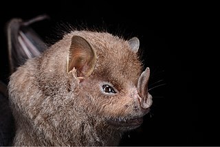
The Guadeloupe big-eyed bat is a species of bat in the family Phyllostomidae. It is found in Guadeloupe and Montserrat. It is threatened by habitat loss mostly because of Hurricane Hugo, which destroyed 90% of its population in 1989. The species may be locally extinct in some areas of Guadeloupe.

The effects of Hurricane Georges in the Lesser Antilles were minimal in certain islands and major on others. Georges had formed on September 15, 1998, off the African coast. It had quickly strengthened into a Category 4 hurricane on the Saffir–Simpson scale on September 20 when it struck the Lesser Antilles with 115 mph (185 km/h) winds. The islands affected include Antigua, Barbuda, the British Virgin Islands, the United States Virgin Islands, Montserrat, Guadeloupe, Dominica, St. Maarten. St. Kitts and Nevis were also affected and sustained the most damage at US$484 million.

The Caribbean is a subregion of the Americas that consists of the Caribbean Sea and its islands ; the nearby coastal areas on the mainland may also be included. The region is southeast of the Gulf of Mexico and the North American mainland, east of Central America, and north of South America.

"Ekbletomys hypenemus" is an extinct oryzomyine rodent from the islands of Antigua and Barbuda, Lesser Antilles. It was described as the only species of the subgenus "Ekbletomys" of genus Oryzomys in a 1962 Ph.D. thesis, but that name is not available under the International Code of Zoological Nomenclature and the species remains formally unnamed. It is currently referred to as "Ekbletomys hypenemus" in the absence of a formally available name. The species is now thought to be extinct, but association with introduced Rattus indicates that it survived until before 1500 BCE on Antigua.
The Montserrat ameiva is a lizard species in the genus Pholidoscelis. It is found on the Caribbean island of Montserrat in the Lesser Antilles.
The Attack on Saint Martin was a failed attempt by the Dutch Republic to recapture the island and former base of the Dutch West India Company (WIC) from the Spanish. In 1633 the Spanish had invaded Saint-Martin and Anguilla, driving off the French and Dutch inhabitants. The French and Dutch banded together to repel the Spanish and it was during a 1644 sea battle that the Dutch commander Peter Stuyvesant, later the governor of New Amsterdam, unsuccessfully besieged Fort Amsterdam and was forced to retreat with the loss of hundreds of men. A stray Spanish cannonball shattered his leg, which had to be amputated. But luck was on the Dutch side, and when the Eighty Years' War between Spain and the Netherlands ended, the Spanish no longer needed a Caribbean base and just sailed away in 1648.
Shirley Osborne is a politician in Montserrat. She was Speaker of the Legislative Assembly of Montserrat between September 2014 and October 2019. She is the daughter of the late John Osborne, a former Chief Minister of Montserrat.
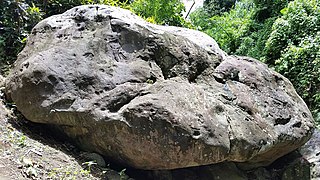
The Mt. Rich Petroglyphs are a series of pre-Columbian petroglyphs, set deep in a ravine along the Saint Patrick River in Mt. Rich, Grenada. The site consists of several boulders carved by ancient Amerindians, the largest of which contains over 60 engravings. Two "workstones" can also be found nearby, comprising six cupules.
Seafaring has played an important role in human history by enabling many prehistoric migration events across the world. Seafaring is especially important in the Caribbean as it represents the only possibility in reaching the Caribbean Islands. Current research has discovered that numerous Pre-Columbian colonisation events occurred in the Caribbean and that an important initial incentive to visit the Caribbean Islands may have been the search for high quality materials, such as flint, clams and oysters and other resources. Although only a limited amount of Pre-Columbian watercraft have been uncovered it has been possible to deduce the appearance and design of some Caribbean canoes. Historical sources offer a plethora of descriptions regarding the appearance and use of Amerindian canoes; however, it is difficult to assess to what extent the Caribbean canoes from the 15th century AD are similar to their counterparts around 5000 years earlier.

The small Caribbean Island of Saba boasts a mere surface area of 13 km2 (5.0 sq mi). However, archaeological surveys and excavations, mainly by Leiden University between 1987 and 2006, have presented Saba as an integral part of the pre-Columbian island network in the Northeastern Caribbean. Archaeological finds from Saba include objects that were traded throughout the Caribbean, such as flint from Antigua, greenstone from St. Martin and pottery from the Greater Antilles. These examples indicate that pre-Columbian communities on Saba were not isolated but fully aware of communities and resources on other islands. Numerous archaeological sites have been uncovered on Saba, dating from around c. 1875 BC up until the point of European contact.
References
- ↑ "Hikers Discover Ancient Petroglyphs in Montserrat". Backpacker. 2016-06-17. Retrieved 2022-10-18.
- 1 2 "Hikers on Caribbean island of Montserrat find ancient stone carvings". the Guardian. 2016-06-03. Retrieved 2022-10-18.
- 1 2 3 4 5 6 7 Cherry, John F.; Ryzewski, Krysta; Guimarães, Susana; Stouvenot, Christian; Francis, Sarita (June 2021). "The Soldier Ghaut Petroglyphs on Montserrat, Lesser Antilles". Latin American Antiquity. 32 (2): 422–430. doi:10.1017/laq.2020.102. ISSN 1045-6635.
- ↑ "Montserrat National Trust announces newly found petroglyphs". Montserrat National Trust. 2016-06-01. Retrieved 2022-10-18.