
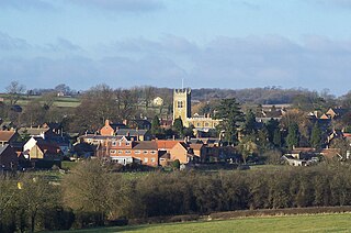
Melton Mowbray is a market town in the Melton district in Leicestershire, England, 19 miles (31 km) north-east of Leicester and 20 miles (32 km) south-east of Nottingham. It lies on the River Eye, known below Melton as the Wreake. The town had a population of 27,670 in 2019. The town is sometimes promoted as Britain's "Rural Capital of Food"; it is the home of the Melton Mowbray pork pie and is the location of one of six licensed makers of Stilton cheese.

Frisby on the Wreake is a village and civil parish on the River Wreake about 3.5 miles (5.6 km) west of Melton Mowbray, Leicestershire, England. The 2011 Census recorded the parish's population as 557.

Woodhouse, often known to locals as Old Woodhouse, is a small village and civil parish in the heart of Charnwood, England. The population of the civil parish at the 2011 census was 2,319, including around 300 term-time boarders at the Defence College. The parish includes the larger village of Woodhouse Eaves. The parish of Woodhouse was formed in 1844. The village is located between the larger Woodhouse Eaves and Quorn villages, the village contains a mixture of small cottages and large modern houses. It is a commuter village for both Leicester and Loughborough, as well as further afield.

Scraptoft is a village in Leicestershire, England. It has a population of about 1,500, measured at the 2011 census as 1,804. It lies north of the A47 road east of Leicester, and runs directly into the built up area of Thurnby and Bushby to the south. For local government the village forms part of the district of Harborough, and constitutes a civil parish.

Freeby is a village and civil parish in the Melton district of Leicestershire, England, about 3 miles (5 km) east of Melton Mowbray. As well as the village of Freeby the civil parish includes the villages of Brentingby, Saxby, Stapleford and Wyfordby. The 2011 Census recorded the parish population as 244.
Redmile is an English village and civil parish in the Melton district of Leicestershire, about ten miles (16 km) north of Melton Mowbray and seven miles (11 km) west of Grantham. The population of the civil parish, which includes Barkestone-le-Vale and Plungar, was 921 at the 2011 census, up from 829 in 2001.

Burrough-on-the Hill is a small village and former civil parish, now in the parish of Somerby, in the Melton district, in the county of Leicestershire, England. It is 12 miles (19 km) north east of Leicester. The parish church is St. Mary the Virgin. Burrough Hill is an Iron Age hill fort near the village and is in an 86-acre (35 ha) country park of the same name. The hillfort stands on a promontory around 660 feet (200 m) above sea level, 7 miles (11 km) south of the modern settlement of Melton Mowbray. In 1931 the parish had a population of 214.

Pickwell is a small, hill-crest village 5 miles (8.0 km) south-east of Melton Mowbray in the Melton district, in Leicestershire which used to have an ecclesiastical parish of its own and is since the early 20th century has been in the civil parish and Church of England parish of Somerby which is 0.5 miles (0.80 km) to the SSW, connected by an almost straight lane.

Leesthorpe is a hamlet in the civil parish of Somerby, in the Melton district, in the English county of Leicestershire.

Stonesby is a village and former civil parish, now in the parish of Sproxton, within the Melton borough of Leicestershire, England. It is 6 miles (9.7 km) northeast of Melton Mowbray, and 1.5 miles (2.4 km) southeast of Waltham on the Wolds. In 1931 the parish had a population of 140.

Thorpe Arnold is a farming village and former civil parish, now in the parish of Waltham on the Wolds and Thorpe Arnold in the district of Melton, which is approximately 1.2 miles (1.9 km) northeast of Melton Mowbray in Leicestershire, England. In 1931 the parish had a population of 128. On 1 April 1936 the parish was abolished and to form Waltham.
Scalford is a village and civil parish in the Melton borough of Leicestershire, England. It lies 4 miles (6.4 km) to the north of Melton Mowbray at the southern end of the Vale of Belvoir. In the 2011 census the parish had a population of 608.
Chadwell is a small village in the district of Melton, which is approximately 4 miles (6.4 km) northeast of Melton Mowbray in Leicestershire, and is part of the civil parish of Scalford, which also includes the neighbouring hamlet of Wycomb. Until 1 April 1936 it was in the parish of Wycomb and Chadwell. The village name means 'spring/stream which is cold'. Chadwell is half a mile east of Wycomb, and they share the Church of St. Mary in the same ecclesiastical parish. The Church of St Mary is a Grade II* listed building.

Sewstern is a village and former civil parish, now in the parish of Buckminster, in the Melton district of east Leicestershire, England. It lies just south of Buckminster, with which it shares a primary school, situated between the two villages. It is 9 miles east of Melton Mowbray, 10 miles south of Grantham and 4 miles from the A1 at Colsterworth. It is the easternmost village in Leicestershire.
Twyford and Thorpe is a civil parish in Leicestershire, England, comprising the villages of Twyford and Thorpe Satchville, and the hamlet of John O'Gaunt. The parish, which is in the Melton district, has a population of 612 at the time of the 2001 census, increasing to 628 at the 2011 census.

Little Dalby is a village and former civil parish, now in the parish of Burton and Dalby, in the Melton district, in the county of Leicestershire, England. It is 4 miles (6 km) south-east of Melton Mowbray. In 1931 the parish had a population of 118. On 1 April 1936 the parish was abolished to form "Burton and Dalby".
Nether Broughton is a village and former civil parish, now in the parish of Broughton and Old Dalby, in the Melton district of Leicestershire, England. Broughton and Old Dalby's parish council is based in Nether Broughton. The village lies on the main A606 road between Melton Mowbray and Nottingham. The neighbouring village of Upper Broughton is on the same road, but within Nottinghamshire. In 1931 the parish had a population of 345. On 1 April 1936 the parish was abolished to form "Broughton and Old Dalby".

Kirby Bellars is a village and civil parish near Melton Mowbray in Leicestershire, England. The population of the civil parish at the 2011 census was 369.

Burrough on the Hill Manor is an 18th-century brick-built house in the village of Burrough on the Hill, in the civil parish of Somerby, in the Melton district, in the county of Leicestershire, England. It is a grade II listed building.

Plungar is a village and former civil parish, now in the parish of Redmile, and the Melton district of Leicestershire, England. It is about 9 miles (14 km) north of the market town of Melton Mowbray and 7 miles (11 km) west from Grantham. Plungar is adjacent to the Grantham Canal and stands in the Vale of Belvoir. In 1931 the parish had a population of 205.


