
Honduras is a country in Central America. Honduras borders the Caribbean Sea and the North Pacific Ocean. Guatemala lies to the west, Nicaragua south east and El Salvador to the south west. Honduras is the second largest Central American republic, with a total area of 112,890 square kilometres (43,590 sq mi).
Nicaragua is a country in Central America, bordering both the Caribbean Sea and the North Pacific Ocean, between Costa Rica and Honduras. Nicaragua is the largest country in Central America in square kilometers.
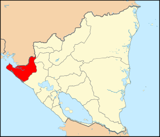
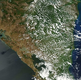
Chinandega is a department in Nicaragua, located on the border with Honduras. It covers an area of 4,822 km2 and has a population of 441,897. The indigenous inhabitants of Chinandega are the Chorotegas and the Nahuas, and was the location of the pre-Columbian Nahua kingdom of Teswatlan. The capital is the city of Chinandega.

Matagalpa is a department in central Nicaragua. It covers an area of 6,804 km2 and has a population of 600,057. The capital is the city of Matagalpa with a population of about 111,000.

Ocotal is the capital of the Nueva Segovia Department in Nicaragua, Central America and the municipal seat of Ocotal Municipality.

Ahuachapán is a city, municipality, and the capital of the Ahuachapán Department in western El Salvador. The municipality, including the city, covers an area of 244.84 km2 and as of 2007 has a population of 110,511 people. Situated near the Guatemalan border, it is the westernmost city in the country and is the center of an agricultural region producing primarily coffee.

Mapulaca is a municipality in the Honduran department of Lempira.

Diriamba is a city and a municipality in the Carazo department of Nicaragua, with a population of 65,243. It is located 41 km south of Managua, the capital of Nicaragua.
Dolores is a municipality in the Carazo department of Nicaragua. It is the smallest municipality in Nicaragua, as it consists only of the urban area or dwellings of its head town.

Chichigalpa o Chichicapan (nahuat) is a town and municipality in the Chinandega Department of Nicaragua.

Chinandega is a city and the departmental seat of Chinandega department in Nicaragua. It is also the administrative centre of the surrounding municipality of the same name. It is Nicaragua's 2nd most important city (economy) and 6th largest city, with a population of 115,067, and a total of 137,539 in the municipality. It is located about 134 kilometres (83 mi) northwest of Managua and about 72 kilometres (45 mi) southwest of El Guasaule, on the border with Honduras. Chinandega is situated about 20 kilometres (12 mi) from the Pacific Ocean.

Tipitapa is a city and municipality in the Managua department of western Nicaragua. The area is located between Lake Managua and Lake Nicaragua.
Masatepe Masatepe is one of the nine municipalities of the Department of Masaya in Nicaragua. It is located on the plateau of the villages 50 kilometers from Managua along the road to Masaya. It belongs to the tourist corridor of " Los Pueblos Blancos" on top of the coffee-producing Volcanic Plateau. The origin of the word "Masatepe" comes from Nahuatl Mazatl-tepec, «populated deer» or mazatl-tepetl, 'Deer Mountain', which comes from the Nicarao who still inhabit the municipality. Nicarao natives dominate the cocoa production in Masatepe.

Sébaco is a town and a municipality in the Matagalpa department of Nicaragua.
Quilalí is a town and a municipality in the Nueva Segovia Department of Nicaragua.
San Juan de Nicaragua, formerly known as San Juan del Norte or Greytown, is a town and municipality in the Río San Juan Department of Nicaragua.
La Cruz de Río Grande is a municipality in the South Caribbean Coast Autonomous Region of Nicaragua. According to the 2005 census, the population of La Cruz de Rio Grande was 3,000. It gets its name from the Rio Grande de Matagalpa which flows through it.

Montoro is a municipality of Spain belonging to the province of Córdoba, Andalusia. Housing lies on a bend of the river Guadalquivir, which envelopes from West, North, and East.

Aldama is a municipality of the northeastern Mexican state of Tamaulipas. According to the census of 2010, the municipality had an area of 3,672 square kilometres (1,418 sq mi) and a population of 29,470, including the town of Aldama with a population of 13,661.

Algarrobo is a town and municipality in the province of Málaga, part of the autonomous community of Andalusia in southern Spain. The municipality is situated in the coastal area of La Axarquía, 32 kilometers from the city of Málaga. It is bordered on the north by the municipality of Arenas and Sayalonga, to the east and west by Vélez-Málaga and to the south by the Mediterranean Sea. It is situated at an altitude of 86 meters. The main center for the population is Algarrobo, a town of Arab architecture situated 3.5 kilometers from the coast. Other towns in the municipality are Algarrobo Costa, Mezquitilla and Trayamar.

