Chichigalpa

Last updated • 2 min readFrom Wikipedia, The Free Encyclopedia
Chichigalpa
Ne Chichic apan
Municipality
Vista aerea ciudad de Chichigalpa.jpg
Aerial view of Chichigalpa.
Nicaragua location map.svg
Red pog.svg
Chichigalpa
Location in Nicaragua
Coordinates: 12°34′N87°02′W / 12.567°N 87.033°W / 12.567; -87.033
CountryFlag of Nicaragua.svg  Nicaragua
Department Chinandega Department
Founded1839
Government
  MayorVíctor Manuel Sevilla
Area
  Municipality86 sq mi (223 km2)
  Urban
1.4 sq mi (3.5 km2)
Population
 (2022 estimate) [1]
  Municipality53,837
  Density630/sq mi (240/km2)
   Urban
43,965
  Urban density33,000/sq mi (13,000/km2)

Chichigalpa (Spanish pronunciation:  [ˈtʃitʃiˈɣalpa] ) o Chichicapan (nahuat) is a town and municipality in the Chinandega Department of Nicaragua.

Contents

History

Pre-Columbian

It is presumed that Chichigalpa's first inhabitants arrived from the north. While their civilizations were not as advanced as those of the Aztecs and the Incans, they arrived at Chichigalpa due to a forced migration instituted by the Aztecs on weaker tribes. Of Toltec origin, the native people of Chichigalpa were presumed to be part of the Kingdom (Monexicado) of Chinandega and Tezoatega hence its name in nahuat nawat.

Initially, it was presumed that the town's name was linked to the nahuat term "chichiwal," which means breast, due to the volcano's shape resembling a breast. However, upon analyzing the town's linguistics, it became apparent that Chichigalpa was derived from the beautiful Chichigalpa river that flows through the city. In pre-colonial times, the river was utilized for washing clothes, bathing, and other purposes, which often made the water appear murky or "chichic" (meaning fermented or sour) due to the soap's cloudiness. "The fermented river" or "Chichicapan" gave the city its name.

Colonial Period

Town hall of Chichigalpa. Alcaldia de Chichigalpa.jpg
Town hall of Chichigalpa.

Geography

Area

The municipality covers an area of 223 km2, but only about 3.5 km2 make up the center of the municipality and its nearby surroundings. Chichigalpa is connected to the city of Chinandega by a paved road (15 km). The municipality connects to the Nicaraguan capital, Managua, through the Pan-American Highway. Chichigalpa forms part of the Western department of Chinandega. It is bordered to the north by the Cordillera Los Maribios (a mountain range), to the south by León, to the east by Posoltega, and to the west by the municipalities of El Realejo and Chinandega.

Climate

Chichigalpa is situated in tropical wet and dry climate (Köppen climate classification: Aw). The dry season last from November to April while the wet season extends from May to October. The average annual precipitation is of 1742 mm (68.58 in). Temperatures are usually the highest in the month of April. [2] The average temperature is 30 °C (89 °F). Relative humidity is 68% and strong winds blow in a northeast to south direction predominantly.

Today

Sugarcane

Sugar accounts from about 5% of Nicaragua’s GDP and the municipality of Chichigalpa has vast areas of sugarcane plantations. A large number of the sugar cane workers have been affected with a chronic kidney disease (CKD). There is a growing scientific view that CKD is linked to harsh work conditions, particularly long hours exposed to sun without sufficient shade, rest and water. Dr Catharina Wesseling, an epidemiologist based at the Karolinska Institute in Sweden said that while other factors - such as pesticides, heavy metals and genetics – could also play a part, there was “absolutely no doubt” that CKD was an occupational disease. [3]

Neighborhoods (Barrios y Comarcas)

The municipality is further divided into many neighborhoods (Barrios y Comarcas):

  • Candelaria
  • Camino de Jesús
  • Carlos Fonseca I, II
  • Concepción
  • El Pueblito
  • Erick Ramirez
  • Juan Jose Briceño
  • La Parroquia
  • La Cruz
  • Las Palmeras
  • Los Lirios
  • Mercedes
  • Marvin Salazar I, II, III
  • Modesto Ramón Palma
  • Nueva Candelaria
  • Nuevo Amanecer
  • Quetzalia
  • Ronald Altamirano II
  • Reparto. 13 de Julio
  • Santiago
  • San Antonio
  • Valle Viejo I, II
  • Wells

Related Research Articles

<span class="mw-page-title-main">Geography of Nicaragua</span> Geographical features of Nicaragua

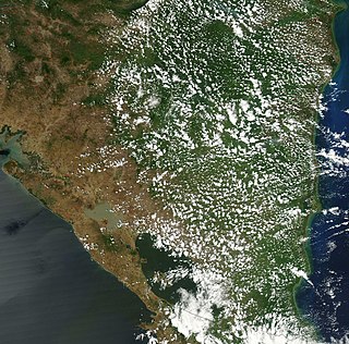
Nicaragua is a country in Central America, bordering both the Caribbean Sea and the North Pacific Ocean, between Costa Rica and Honduras. Nicaragua is the largest country in Central America in square kilometers.

<span class="mw-page-title-main">Guanacaste Province</span> Province of Costa Rica

Guanacaste is a province of Costa Rica located in the northwestern region of the country, along the coast of the Pacific Ocean. It is bordered by Nicaragua to the north, Alajuela Province to the east, and Puntarenas Province to the southeast. It is the most sparsely populated of all the provinces of Costa Rica. The province covers an area of 10,141 square kilometres (3,915 sq mi) and as of 2010, had a population of 354,154, with annual revenue of $2 million.

<span class="mw-page-title-main">Carazo Department</span> Department of Nicaragua

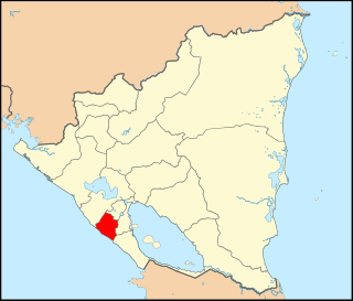
Carazo is a department in Nicaragua. It covers an area of 1,081 km2 and has a population of 198,395. The capital is Jinotepe.

<span class="mw-page-title-main">Chinandega Department</span> Department of Nicaragua

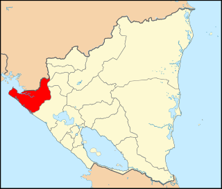
Chinandega is a department in Nicaragua, located on the border with Honduras. It covers an area of 4,822 km2 and has a population of 441,897. The capital is the city of Chinandega.

Zacazonapan is a municipality near Mexico City. It's municipal seat is the village of Zacazonapan. The name comes from Nahuatl and roughly translates to "in the River of the Dry Corn plants"

<span class="mw-page-title-main">Otatitlán</span> Town and municipality in Veracruz, Mexico

Otatitlán is a town and municipality in the Mexican state of Veracruz, in the south of the state along the border with the state of Oaxaca. The town is best known for its large black image of a crucified Christ, one of three notable images of this type. Most of the population in Otatitlán is poor and the area is dedicated to agriculture, especially sugar cane and bananas.

<span class="mw-page-title-main">Santo Antão, Cape Verde</span> Westernmost and largest of the Barlavento islands of Cape Verde

Santo Antão is the westernmost island of Cape Verde. At 785 km2 (303 sq mi), it is the largest of the Barlavento Islands group, and the second largest island of Cape Verde. The nearest island is São Vicente to the southeast, separated by the sea channel Canal de São Vicente. Its population was 38,200 in mid 2019, making it the fourth most populous island of Cape Verde after Santiago, São Vicente and Sal. Its largest city is Porto Novo located on the southern coast.

<span class="mw-page-title-main">Barahona, Dominican Republic</span> Place in Barahona, Dominican Republic

Barahona, also known as Santa Cruz de Barahona, is the main city of the Barahona Province, in the southwest of the Dominican Republic. It has one of the most active ports in the region, as well as many ecotourism attractions. The city is a centre of sugar production and industry. Barahona is also known for being the only place where the rare Larimar stone can found.

<span class="mw-page-title-main">Zarzal</span> Municipality and city in Valle del Cauca, Colombia

Zarzal is a city and municipality in the north of the department of Valle del Cauca in Colombia. Its economy is based primarily on the extensive cultivation of sugar cane, on small and medium enterprises in the metallurgic sector, and on utilities. Commerce is also of great importance, because a great number of warehouses for basic necessity goods exist in the city. A marketplace also exists, which serves as reference for various cities that are close by. Zarzal municipality has a population of about 42,000. New city districts were constructed in the center of the city; it has now become difficult to find bare land inside the city.

<span class="mw-page-title-main">Diriamba</span> Municipality in Carazo Department, Nicaragua

Diriamba is a city and a municipality in the Carazo department of Nicaragua, with a population of 65,243. It is located 41 km south of Managua, the capital of Nicaragua.

<span class="mw-page-title-main">Jinotepe, Carazo</span> Municipality in Carazo Department, Nicaragua

Jinotepe is a city and municipality in the Carazo department of Nicaragua.

<span class="mw-page-title-main">Chinandega</span> Municipality in Chinandega Department, Nicaragua

Chinandega is a city and the departmental seat of Chinandega department in Nicaragua. It is also the administrative centre of the surrounding municipality of the same name. It is Nicaragua's 2nd most important city (economy) and 6th largest city, with a population of 115,067, and a total of 137,539 in the municipality. It is located about 134 kilometres (83 mi) northwest of Managua and about 72 kilometres (45 mi) southwest of El Guasaule, on the border with Honduras. Chinandega is situated about 20 kilometres (12 mi) from the Pacific Ocean.

Somotillo is a town and a municipality in the Chinandega department of Nicaragua.

<span class="mw-page-title-main">Tipitapa</span> Municipality in Managua, Nicaragua

Tipitapa is a city and municipality in the Managua department of western Nicaragua. The area is located between Lake Managua and Lake Nicaragua.

<span class="mw-page-title-main">Quilalí</span> Municipality in Nueva Segovia Department, Nicaragua

Quilalí is a town and a municipality in the Nueva Segovia Department of Nicaragua.

<span class="mw-page-title-main">Gurupi</span> Place in Norte

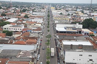
Gurupi, Tocantins is a city and a municipality in the Brazilian state of Tocantins. The estimated population was 87,545 inhabitants in 2020, the third-largest in the state, and the total area of the municipality was 1,836 kmª. The elevation is around 287 meters in the city.

<span class="mw-page-title-main">Retamal de Llerena</span> Place in Extremadura, Spain

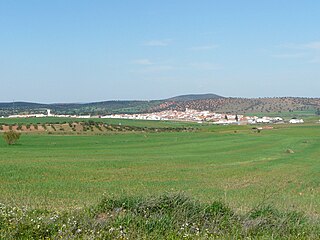
Retamal de Llerena is a municipality located in the province of Badajoz, Extremadura, Spain. According to the 2008 census (INE), it has a population of 497 people.

Huautla de Jimenez is a town and municipality in the Mexican state of Oaxaca. It is part of the Teotitlán District in the north of the Cañada Region.

Santo Domingo Ingenio is a town and municipality in Oaxaca in south-western Mexico. It is part of the Juchitán District in the west of the Istmo de Tehuantepec region.

<span class="mw-page-title-main">El Naranjo, San Luis Potosí</span> Municipality and town in San Luis Potosí, Mexico

El Naranjo is a town and a municipality in the Mexican state of San Luis Potosí in central Mexico. The municipality, created in 1994, has an area of 834 square kilometres (322 sq mi) with a population of 20,495 in 2010, including the town of El Naranjo with a population of 10,562. The town is located at 22°31′19″N99°19′31″W.

References

  1. Citypopulation.de Population of Chichigalpa municipality
  2. "Climate: Chichigalpa". Climate-Data.org. Retrieved 28 June 2014.
  3. "Nicaraguans demand action over illness killing thousands of sugar cane workers". TheGuardian.com . 16 February 2015.

Bibliography

12°34′N87°02′W / 12.567°N 87.033°W / 12.567; -87.033