The economy of Tanzania is a lower-middle income economy that is overwhelmingly dependent on agriculture. Tanzania's economy has been transitioning from a command economy to a market economy since 1985. Although total GDP has increased since these reforms began, GDP per capita dropped sharply at first, and only exceeded the pre-transition figure in around 2007.
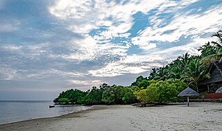
Mafia Island or Chole Shamba is an island of The Mafia Archipelago located in Mafia District in the southern Pwani Region of Tanzania across the Mafia Channel. The island is the third largest in Tanzanian ocean territory, but is not administratively included within the semi-autonomous region of Zanzibar, which has been politically separate since 1890. Mafia Island forms the largest part of Mafia District, one of the six administrative districts in the Pwani Region. As the Mafia Archipelago's main islan, is sometimes called Chole shamba in meaning Chole farmlands Swahili. This is in opposition to the historic settlement of Chole Mjini(Chole town) on Chole Island inside Mafia Bay. The island's population is over 40,000. The economy is based on fishing, subsistence agriculture and the market in Kilindoni. The island attracts some tourists, mainly scuba divers, birdwatchers, game fishermen, and people seeking relaxation.

Kilwa Kisiwani is an island, national historic site, and hamlet community located in the township of Kilwa Masoko, the district seat of Kilwa District in the Tanzanian region of Lindi Region in southern Tanzania. Kilwa Kisiwani is the largest of the nine hamlets in the town Kilwa Masoko and is also the least populated hamlet in the township with fewer than 1,000 residents.

Kilwa District is one of six administrative districts of Lindi Region in Tanzania. The District covers an area of 15,000 km2 (5,800 sq mi). The district is comparable in size to the land area of the nation state of East Timor. Kilwa district is bordered to the north by Rufiji District in Pwani Region, to the east by the Indian Ocean, to the south by the Lindi District, Nachingwea District together with Ruangwa District, and to the west by the Liwale District. The district borders every other district in Lindi Region except Lindi Municipal District. The district seat (capital) is the town of Kilwa Masoko. The district is named after the medieval Swahili city state of Kilwa Kisiwani. According to the 2012 census, the district has a total population of 190,744.
The Matumbi are a Bantu ethnolinguistic group native to Kilwa District, Lindi Region in southern Tanzania, who speak the Matumbi language. They are also the native inhabitants of the Songosongo island archipelago. Their homeland is also south of the Rufiji delta in southern Pwani Region in Rufiji District. In 1978 the Matumbi population was estimated to number 72,000. They are the largest ethnic group in Kilwa District. The Matumbi Highlands are named after them.

Swahili architecture is a term used to designate a whole range of diverse building traditions practiced or once practiced along the eastern and southeastern coasts of Africa. Rather than simple derivatives of Islamic architecture from the Arabic world, Swahili stone architecture is a distinct local product as a result of evolving social and religious traditions, environmental changes, and urban development.
Songo Songo Island or sometimes spelled, Songosongo Island is a coral island in the Songosongo Archipelago. The island is governed by the Songosongo ward in Kilwa District of Lindi Region in Tanzania's Indian ocean coast. It is served by the Songo Songo Airstrip. The island's native inhabitants are the Matumbi people.

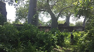
Songo Mnara is a historic Swahiili settlement in located on Songo Mnara Island in Pande Mikoma, Kilwa District in Lindi Region of Tanzania. The island is home to a Medieval Swahili stone town. The stone town was occupied from the 14th to 16th centuries. Songo Mnara has been recognized as a UNESCO World Heritage Site, along with nearby stone town Kilwa Kisiwani. In total, archaeologists have found six mosques, four cemeteries, and two dozen house blocks along with three enclosed open spaces on the island. Songo Mnara was constructed from rough-coral and mortar. This stonetown was built as one of many trade towns on the Indian Ocean. The site is a registered National Historic Site.

Ubungo I Thermal Power Station, also known as the Ubungo Power Plant, is a natural gas-fueled power plant located in Ubungo of Ubungo District in Dar es Salaam Region of Tanzania. It began commercial operations on 30 July 2008 with an installed capacity of 110 megawatts (150,000 hp).
The East African coral coast is a marine ecoregion along the eastern coast of Africa. It extends along the coasts of Kenya, Tanzania, and northern Mozambique, from Lamu in Kenya to Angoche in Mozambique. It adjoins the Northern Monsoon Current Coast ecoregion to the north, and the Bight of Sofala/Swamp Coast ecoregion to the south.
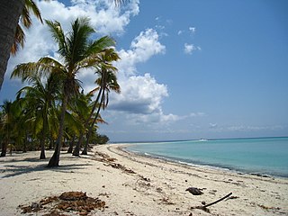
Songosongo is an administrative ward in Kilwa District of Lindi Region in Tanzania. The ward covers an area of 8.5 km2 (3.3 sq mi), and has an average elevation of 11 m (36 ft). According to the 2012 census, the ward has a total population of 3,056. The ward administers the whole archipelago of the Songosongo Islands, which are composed of 22 coral reefs and 4 coral islands; Songo Songo Island, Fanjove Island, Nyuni Island and Okuza Island. The islands ward's native inhabitants are the Matumbi people. The archipelago is composed of 21 coral reefs including the 4 islands. The ward seat is Songosongo village. In addition there are four hamlets on the islands; Pembeni, Makondeni, Msitumani and Funguni.
Fanjove Island is a coral island in the Songosongo Archipelago. The island is governed by the Songosongo ward in Kilwa District of Lindi Region in Tanzania's Indian ocean coast. The island is a geographically part of the Songosongo Islands archipelago which is composed of 22 reefs and 4 islands. The other three islands in the archipelago are Songo Songo, Nyuni Island and Okuza Island. The is land is originally been uninhabited, thus it has been leased to a luxury hotelier by the Tanzanian government. On January 12, 2000, 11 Indo-Pacific bottlenose dolphin that had become live-stranded on Fanjove Island were reported as having been refloated and released.
Okuza Island is a coral island in the Songosongo Archipelago. The island is governed by the Songosongo ward in Kilwa District of Lindi Region in Tanzania's Indian ocean coast. Geographically, the island is part of the Songosongo Islands archipelago which is composed of 22 reefs and 4 islands. The other three islands are Songo Songo, Fanjove Island and Nyuni Island.
Nyuni Island is a coral island in the Songosongo Archipelago. The island is governed by the Songosongo ward in Kilwa District of Lindi Region in Tanzania's Indian ocean coast. Geographically, the island is part of the Songosongo Islands archipelago which is composed of 22 reefs and 4 islands. The other three islands are Songo Songo, Fanjove Island and Okuza Island. Nyuni island has an elevation of 14m and is under the national natural gas exploration and extraction initiative.

Pande Mikoma is an administrative ward in Kilwa District of Lindi Region in Tanzania. The ward covers an area of 201.6 km2 (77.8 sq mi), and has an average elevation of 60 m (200 ft). According to the 2012 census, the ward has a total population of 8,094. The ward is home to the island of Songo Mnara Island which is home to the ruins of Songo Mnara, a World Heritage Site. The ward seat is Pande village.
Songo Mnara Island is an island located in Pande Mikoma ward in Kilwa District in Lindi Region of Tanzania's Indian Ocean coast. The island is home to the UNESCO World Heritage Site of Songo Mnara, one of seven world heritage sites in the country. In total, the island covers an area of 8.5 km2 (3.3 sq mi), and has an average elevation of 9 m (30 ft). The Island is the ancestral home of the Machinga people.

The Mafia Archipelago or The Mafia Islands is an group of islands across the Mafia Channel in the Mafia District of Pwani Region's coast on the Sea of Zanj in Tanzania's Indian Ocean coast. The archipelago is composed of 9 islands and around 12 coral reefs. In total, the Mafia archipelago covers 972 km2 (375 sq mi) in total, of which 8.5 km2 (3.3 sq mi) 407 km2 are land and 565 km2 are water. and has an average elevation of 53 m (174 ft). Of the 12 reefs in the archipelago the most famous one is the Tutia Reef. The nine Islands in the archipelago are. The largest island in the archipelago is Mafia Island also known as Chole Shamba locally. The other eight islands inside Mafia District in addition to Mafia Island are; Juani Island, Chole Island, Jibondo Island (Kibondo), Bwejuu Island, Shungumbili Island (Thanda), Barakuni Island, Miewi Island, and Niororo Island (Nyororo).