
Mohali district, officially known as Sahibzada Ajit Singh Nagar district or SAS Nagar district, is one of the twenty three districts of Punjab, a state in north-west India. It was formed in April 2006 and is 18th district of Punjab, created next to Pathankot district. This district was carved out of areas falling in Ropar and Patiala District. It is situated next to the union territory of Chandigarh, Ambala And Panchkula district of Haryana.

Ramnagar I is a community development block that forms an administrative division in Contai subdivision of Purba Medinipur district in the Indian state of West Bengal.
A tehsil is a local unit of administrative division in India and Pakistan. It is a subdistrict of the area within a district including the designated populated place that serves as its administrative centre, with possible additional towns, and usually a number of villages. The terms in India have replaced earlier terms, such as pargana (pergunnah) and thana.

In India, a Community development block or simply Block is a sub-division of Tehsil, administratively earmarked for planning and development. In tribal areas, similar sub-divisions are called tribal development blocks. The area is administered by a Block Development Officer (BDO), supported by several technical specialists and village-level workers. A community development block covers several gram panchayats, the local administrative units at the village level.

Patashpur I is a community development block that forms an administrative division in Egra subdivision of Purba Medinipur district in the Indian state of West Bengal.

Moyna is a community development block that forms an administrative division in Tamluk subdivision of Purba Medinipur district in the Indian state of West Bengal.

Nandakumar is a community development block that forms an administrative division in Tamluk subdivision of Purba Medinipur district in the Indian state of West Bengal.

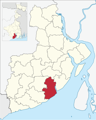
Tamluk is a community development block that forms an administrative division in Tamluk subdivision of Purba Medinipur district in the Indian state of West Bengal.

Sahid Matangini is a community development block that forms an administrative division in Tamluk subdivision of Purba Medinipur district in the Indian state of West Bengal.

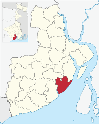
Kolaghat is a community development block that forms an administrative division in Tamluk subdivision of Purba Medinipur district in the Indian state of West Bengal.

Nandigram I is a community development block that forms an administrative division in Haldia subdivision of Purba Medinipur district in the Indian state of West Bengal.

Nandigram II is a community development block that forms an administrative division in Haldia subdivision of Purba Medinipur district in the Indian state of West Bengal.
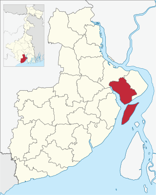
Haldia is a community development block that forms an administrative division in Haldia subdivision of Purba Medinipur district in the Indian state of West Bengal. In earlier days this block was referred to as Sutahata II block, and Sutahata block was referred to as Sutahata I block.

Egra I is a community development block that forms an administrative division in Egra subdivision of Purba Medinipur district in the Indian state of West Bengal.

Egra II is a community development block that forms an administrative division in Egra subdivision of Purba Medinipur district in the Indian state of West Bengal.

Contai I is a community development block that forms an administrative division in Contai subdivision of Purba Medinipur district in the Indian state of West Bengal.
Deshapran is a community development block that forms an administrative division in Contai subdivision of Purba Medinipur district in the Indian state of West Bengal.

Contai III is a community development block that forms an administrative division in Contai subdivision of Purba Medinipur district in the Indian state of West Bengal.
Khejuri II is a Community Development Block that forms an administrative division in Contai subdivision of Purba Medinipur district in the Indian state of West Bengal.

Bhagipur is a village in Unchahar block of Raebareli district, Uttar Pradesh, India. It is located 34 km from Raebareli, the district headquarters. As of 2011, it has a population of 446 people, in 89 households.


