
Longford is the county town of County Longford in Ireland. It has a population of 10,008 according to the 2016 census. It is the biggest town in the county and about one third of the county's population lives there. Longford lies at the meeting of Ireland's N4 and N5 National Primary Route roads, which means that traffic travelling between Dublin and County Mayo, or north County Roscommon passes around the town. Longford railway station, on the Dublin-Sligo line, is used heavily by commuters.

Castlepollard is a village in north County Westmeath, Republic of Ireland. It lies west of Lough Lene and northeast of Lough Derravaragh and Mullingar.

Carrigallen is a small village in County Leitrim, Ireland. It is located on the R201 and R203 roads in the east of the county. As of 2016, the village had a population of 387.
Newtowncashel is a village located near Lough Ree in County Longford, Ireland. It is within the townland of Cornadowagh. Newtowncashel won the Irish Tidy Towns Competition in 1980.
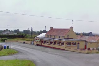
Drumlish is a village in County Longford, Ireland on the R198 regional road 10 km (6.2 mi) north of Longford Town.

Lisryan is a village in County Longford, Ireland.
Brickeens is a very small townland in County Longford, Ireland. It is about five kilometres north of Keenagh and eight kilometres south of Longford town. Brickeens townland has an area of approximately 146 acres (0.2 sq mi), and had a population of 21 people as of the 2011 census. Evidence of ancient settlement in the townland include two ringforts.
Rahugh or Ráith Aeda Meic Bric is an early Christian site founded by Áed mac Bricc in the 6th century, inside a ráth or ringfort. The site, located about 8 km north of Tullamore along the L1024.
The Aghaward fort is a ringfort (rath) and National Monument located in County Longford, Ireland.
Larkfield fort is a ringfort (rath) and National Monument located in County Longford, Ireland. On the Record of Monuments and Places it bears the code LF006-021----.
Cashelore, also called Cashel Bir or Bawnboy, is a stone ringfort (cashel) and National Monument located in County Sligo, Ireland.
Barnacahoge Cashel, is a stone ringfort (cashel) and National Monument located in County Mayo, Ireland.
Blossomfort is a ringfort (rath) and National Monument (#594) located in County Cork, Ireland.
Cahervagliar is a ringfort (rath) and National Monument (#233) located in County Cork, Ireland.

Loher Cashel is a stone ringfort (cashel) and National Monument located on the Iveragh Peninsula, Ireland.
Leacanabuaile is a stone ringfort (cashel) and National Monument in County Kerry, Ireland. Leacanabuaile is immediately northwest of Cahergal, 3 km (1.9 mi) northwest of Cahirciveen.
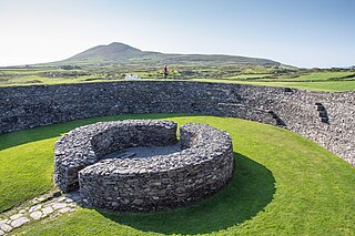
Cahergall is a stone ringfort (cashel) and National Monument located in County Kerry, Ireland.
Caheravoley Fort is a ringfort (rath) and bawn forming a National Monument located in County Galway, Ireland.
Ballynavenooragh is a stone fort and National Monument located in County Kerry, Ireland.
Aughnacliffe, officially Aghnacliff , is a village in County Longford, Ireland. It is located close to Lough Gowna and the border with County Cavan.
