
The Mississippi River is the primary river, and second-longest river, of the largest drainage basin in the United States. From its traditional source of Lake Itasca in northern Minnesota, it flows generally south for 2,340 miles (3,766 km) to the Mississippi River Delta in the Gulf of Mexico. With its many tributaries, the Mississippi's watershed drains all or parts of 32 U.S. states and two Canadian provinces between the Rocky and Appalachian mountains. The main stem is entirely within the United States; the total drainage basin is 1,151,000 sq mi (2,980,000 km2), of which only about one percent is in Canada. The Mississippi ranks as the thirteenth-largest river by discharge in the world. The river either borders or passes through the states of Minnesota, Wisconsin, Iowa, Illinois, Missouri, Kentucky, Tennessee, Arkansas, Mississippi, and Louisiana.

The Quad Cities is a region of cities in the U.S. states of Iowa and Illinois: Davenport and Bettendorf in southeastern Iowa, and Rock Island, Moline and East Moline in northwestern Illinois. These cities are the center of the Quad Cities metropolitan area, a region within the Mississippi River Valley, which as of 2013 had a population estimate of 383,781 and a Combined Statistical Area (CSA) population of 474,937, making it the 90th-largest CSA in the nation.

A swing bridge is a movable bridge that has as its primary structural support a vertical locating pin and support ring, usually at or near to its center of gravity, about which the swing span can then pivot horizontally as shown in the animated illustration to the right. Small swing bridges as found over canals may be pivoted only at one end, opening as would a gate, but require substantial underground structure to support the pivot.

The National Register of Historic Places in the United States is a register including buildings, sites, structures, districts, and objects. The Register automatically includes all National Historic Landmarks as well as all historic areas administered by the U.S. National Park Service. Since its introduction in 1966, more than 90,000 separate listings have been added to the register.
The Wabash Trace Nature Trail is a 63-mile (101 km) rail trail located in Iowa which stretches from the city of Council Bluffs southeast to the city of Blanchard.

Three Rivers Park District is a special park district serving the suburban areas of the Twin Cities including suburban Hennepin, Carver, Dakota, Scott, and Ramsey counties. Three Rivers's mission is "To promote environmental stewardship through recreation and education in a natural resources-based park system." Three Rivers operates twenty parks and ten regional trails, with at least two more regional trails planned. Nearly seven million people visit Three Rivers facilities each year. It has over 27,000 acres (11,000 ha) of parks and trails.

The Crescent Bridge carries a rail line across the Mississippi River between Davenport, Iowa and Rock Island, Illinois. It was formerly owned by the Davenport, Rock Island and North Western Railway, a joint subsidiary of the Chicago, Burlington and Quincy Railroad and Chicago, Milwaukee, St. Paul and Pacific Railroad, which was split in 1995 between then-joint owners Burlington Northern Railroad and Soo Line Railroad, with BN getting the bridge and the Illinois-side line, and Soo Line getting the Iowa-side line. Since then, after spinning off its lines in the area to I&M Rail Link, later Iowa, Chicago and Eastern Railroad, the lines were repurchased by the Canadian Pacific Railway, parent of the Soo Line. Meanwhile, BN has merged into the BNSF Railway, the current owner of the bridge.

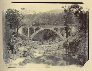
The Government Bridge or Arsenal Bridge spans the Mississippi River, connecting Rock Island, Illinois and Davenport, Iowa. The Iowa Interstate Railroad uses the upper deck of the bridge for its ex-Chicago and Rock Island Railroad route between Council Bluffs, Iowa and Chicago, Illinois. The lower deck carries automobile traffic between the two cities. It is located near Upper Mississippi Mile Marker 483, adjacent to the Mississippi River Lock and Dam No. 15. The current structure is the fourth at this location. The bridges all were built with a swing section to accommodate traffic navigating the river.

The Eau Claire–Chippewa Falls metropolitan area refers loosely to the urbanized area along the Chippewa and Eau Claire Rivers, in west-central Wisconsin, with its primary center at Eau Claire and secondary centers at Chippewa Falls and Altoona.

The Short Line Bridge is a truss bridge that spans the Mississippi River in Minneapolis, Minnesota, United States. It was originally built in the 1880s and upgraded a few years later by Chicago, Milwaukee, St. Paul and Pacific Railroad and was designed by American Bridge Company.

Air Line State Park Trail is a rail trail and linear state park located in Connecticut. The trail is divided into sections designated South, North a piece of the East Coast Greenway, and the Thompson addition. An additional 3.6-mile spur to Colchester is sometimes designated as part of the Air Line trail. At the Massachusetts state line, the trail connects to the Southern New England Trunkline Trail, a 22-mile-long trail to Franklin, MA built on the same right-of-way. Since 2018, the town of Portland, CT has also maintained a 2.3-mile portion of the Air Line trail, connecting to the southern end of the state park at the town line with East Hampton.

Lock and Dam No. 19 is a lock and dam located on the Upper Mississippi River near Keokuk, Iowa. In 1978, the Keokuk Lock and Dam was listed in the National Register of Historic Places, #78001234. In 2004, the facility was listed in the National Register of Historic Places as Lock and Dam No. 19 Historic District, #04000179 covering 1,605 acres (650 ha), 7 buildings, 12 structures, 1 object. The lock is owned and operated by the U.S. Army Corps of Engineers. The dam is owned and operated by Ameren Missouri.

Blanchard Dam is a dam across the Mississippi River, in Bellevue Township and Swan River Township, Morrison County, near the city of Royalton, Minnesota. Blanchard is a hydroelectric station owned and operated by Minnesota Power. The dam sits slightly upriver from the former Soo Line rail bridge. The bridge now carries a recreational trail.

The Lake Wobegon Trail are two paved recreational rail trails in central Minnesota, named after the fictional Lake Wobegon in Garrison Keillor's "Prairie Home Companion". Each trail is marked with mileposts every 0.5 miles (0.80 km), corresponding with the mile markers of the former railroad lines. Snowmobile use is allowed on the trail in winter, conditions permitting.

High Trestle Trail is a rail trail running from Ankeny to Woodward in central Iowa. The recreation trail opened on April 30, 2011. It is a paved recreational trail that runs through the Polk, Story, Boone, and Dallas counties. The trail's name is derived from a former 1913 bridge that spanned the Des Moines River between the towns of Madrid and Woodward.
The Mungar Junction to Monto railway line is a 267-kilometre (166 mi) railway in Queensland, Australia. Progressively opened in eleven stages between 1889 and 1928 the line branched from the North Coast line at Mungar Junction a short distance west of Maryborough and followed a westerly route towards Biggenden and Gayndah before turning north via Mundubbera and Eidsvold to Monto. It is also known as the Gayndah Monto Branch Railway. In 2012, the line was officially closed.
Byellee to Monto Branch Railway was a branch railway that branched off the Boyne Valley west of Gladstone in Queensland, Australia.The Boyne Valley region was predominantly a dairying region and a railway had little justification. However a branch was justified in 1906 on the basis of large traffic in timber, fuel, limestone and flexing ores. Progressively opened between 1910 and 1931 the line branched from the North Coast line at Byellee a short distance west of Gladstone and struck a south-westerly route via Many Peaks and Mungungo to Monto.
The Palisade Rail Bridge is a steel through truss bridge, originally built by the Minneapolis, St. Paul and Sault Ste. Marie Railway in 1910 to cross the Mississippi River at Palisade, Minnesota. The rail line was closed in 1985. Today, the bridge is part of the Soo Line North ATV Trail in northern Minnesota.

