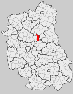
Gmina Uścimów is a rural gmina in Lubartów County, Lublin Voivodeship, in eastern Poland. Its seat is the village of Uścimów, which lies approximately 24 kilometres (15 mi) east of Lubartów and 36 km (22 mi) north-east of the regional capital Lublin.
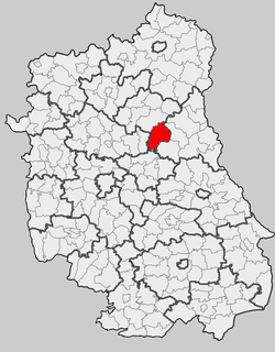
Gmina Sosnowica is a rural gmina in Parczew County, Lublin Voivodeship, in eastern Poland. Its seat is the village of Sosnowica, which lies approximately 20 kilometres (12 mi) south-east of Parczew and 48 km (30 mi) north-east of the regional capital Lublin.

Bohutyn is a village in the administrative district of Gmina Sosnowica, within Parczew County, Lublin Voivodeship, in eastern Poland. It lies approximately 18 kilometres (11 mi) south-east of Parczew and 49 km (30 mi) north-east of the regional capital Lublin.
Górki is a village in the administrative district of Gmina Sosnowica, within Parczew County, Lublin Voivodeship, in eastern Poland. It lies approximately 3 kilometres (2 mi) south of Sosnowica, 22 km (14 mi) south-east of Parczew, and 46 km (29 mi) north-east of the regional capital Lublin.
Izabelin is a village in the administrative district of Gmina Sosnowica, within Parczew County, Lublin Voivodeship, in eastern Poland. It lies approximately 23 kilometres (14 mi) south-east of Parczew and 51 km (32 mi) north-east of the regional capital Lublin.
Komarówka is a village in the administrative district of Gmina Sosnowica, within Parczew County, Lublin Voivodeship, in eastern Poland. It lies approximately 6 kilometres (4 mi) south-west of Sosnowica, 22 km (14 mi) south-east of Parczew, and 42 km (26 mi) north-east of the regional capital Lublin.
Kropiwki is a village in the administrative district of Gmina Sosnowica, within Parczew County, Lublin Voivodeship, in eastern Poland. It lies approximately 7 kilometres (4 mi) north-east of Sosnowica, 21 km (13 mi) east of Parczew, and 54 km (34 mi) north-east of the regional capital Lublin.
Lejno is a village in the administrative district of Gmina Sosnowica, within Parczew County, Lublin Voivodeship, in eastern Poland. It lies approximately 9 kilometres (6 mi) south of Sosnowica, 25 km (16 mi) south-east of Parczew, and 41 km (25 mi) north-east of the regional capital Lublin.
Libiszów is a village in the administrative district of Gmina Sosnowica, within Parczew County, Lublin Voivodeship, in eastern Poland. It lies approximately 4 kilometres (2 mi) west of Sosnowica, 17 km (11 mi) south-east of Parczew, and 46 km (29 mi) north-east of the regional capital Lublin.
Lipniak is a village in the administrative district of Gmina Sosnowica, within Parczew County, Lublin Voivodeship, in eastern Poland. It lies approximately 9 kilometres (6 mi) south-east of Sosnowica, 28 km (17 mi) south-east of Parczew, and 48 km (30 mi) north-east of the regional capital Lublin.
Mościska is a village in the administrative district of Gmina Sosnowica, within Parczew County, Lublin Voivodeship, in eastern Poland. It lies approximately 5 kilometres (3 mi) north of Sosnowica, 19 km (12 mi) south-east of Parczew, and 52 km (32 mi) north-east of the regional capital Lublin.
Nowy Orzechów is a village in the administrative district of Gmina Sosnowica, within Parczew County, Lublin Voivodeship, in eastern Poland. It lies approximately 9 kilometres (6 mi) south-west of Sosnowica, 22 km (14 mi) south-east of Parczew, and 39 km (24 mi) north-east of the regional capital Lublin.
Olchówka is a village in the administrative district of Gmina Sosnowica, within Parczew County, Lublin Voivodeship, in eastern Poland. It lies approximately 5 kilometres (3 mi) north-east of Sosnowica, 19 km (12 mi) south-east of Parczew, and 51 km (32 mi) north-east of the regional capital Lublin.
Pasieka is a village in the administrative district of Gmina Sosnowica, within Parczew County, Lublin Voivodeship, in eastern Poland. It lies approximately 4 kilometres (2 mi) south-east of Sosnowica, 24 km (15 mi) south-east of Parczew, and 49 km (30 mi) north-east of the regional capital Lublin.
Sosnowica-Dwór is a village in the administrative district of Gmina Sosnowica, within Parczew County, Lublin Voivodeship, in eastern Poland. It lies approximately 6 kilometres (4 mi) south-east of Sosnowica, 26 km (16 mi) south-east of Parczew, and 50 km (31 mi) north-east of the regional capital Lublin.
Stary Orzechów is a village in the administrative district of Gmina Sosnowica, within Parczew County, Lublin Voivodeship, in eastern Poland. It lies approximately 6 kilometres (4 mi) south-west of Sosnowica, 20 km (12 mi) south-east of Parczew, and 42 km (26 mi) north-east of the regional capital Lublin.
Turno is a village in the administrative district of Gmina Sosnowica, within Parczew County, Lublin Voivodeship, in eastern Poland. It lies approximately 23 kilometres (14 mi) south-east of Parczew and 54 km (34 mi) north-east of the regional capital Lublin.
Zienki is a village in the administrative district of Gmina Sosnowica, within Parczew County, Lublin Voivodeship, in eastern Poland. It lies approximately 25 kilometres (16 mi) south-east of Parczew and 45 km (28 mi) north-east of the regional capital Lublin.
Zbójno is a village in the administrative district of Gmina Sosnowica, within Parczew County, Lublin Voivodeship, in eastern Poland. It lies approximately 6 kilometres (4 mi) south-east of Sosnowica, 26 km (16 mi) south-east of Parczew, and 50 km (31 mi) north-east of the regional capital Lublin.

Gmina Dębowa Kłoda is a rural gmina in Parczew County, Lublin Voivodeship, in eastern Poland. Its seat is the village of Dębowa Kłoda, which lies approximately 12 kilometres (7 mi) east of Parczew and 50 km (31 mi) north-east of the regional capital Lublin.


