
Dejima, in the 17th century also called Tsukishima, was an artificial island off Nagasaki, Japan that served as a trading post for the Portuguese (1570–1639) and subsequently the Dutch (1641–1854). For 220 years, it was the central conduit for foreign trade and cultural exchange with Japan during the isolationist Edo period (1600–1869), and the only Japanese territory open to Westerners.

The Ryukyuan languages, also Lewchewan or Luchuan, are the indigenous languages of the Ryukyu Islands, the southernmost part of the Japanese archipelago. Along with the Japanese language and the Hachijō language, they make up the Japonic language family.

Yonaguni, one of the Yaeyama Islands, is the westernmost inhabited island of Japan, lying 108 kilometers (67 mi) from the east coast of Taiwan, between the East China Sea and the Pacific Ocean proper. The island is administered as the town of Yonaguni, Yaeyama Gun, Okinawa, and there are three settlements: Sonai, Kubura, and Higawa.

Iejima, previously romanized in English as Ie Shima, is an island in Okinawa Prefecture, Japan, lying a few kilometers off the Motobu Peninsula on Okinawa Island. The island measures 20 kilometres (12 mi) in circumference and covers 23 square kilometres (8.9 sq mi). As of December 2012 the island had a population of 4,610. Ie Village, which covers the entire island, has a ferry connection with the town of Motobu on Okinawa Island.

Sakoku was the isolationist foreign policy of the Japanese Tokugawa shogunate under which, for a period of 265 years during the Edo period, relations and trade between Japan and other countries were severely limited, and nearly all foreign nationals were banned from entering Japan, while common Japanese people were kept from leaving the country.

Tsushima Island is an island of the Japanese archipelago situated in-between the Tsushima Strait and Korea Strait, approximately halfway between Kyushu and the Korean Peninsula. The main island of Tsushima, once a single island, was divided into two in 1671 by the Ōfunakoshiseto canal and into three in 1900 by the Manzekiseto canal. These canals were driven through isthmuses in the center of the island, forming "North Tsushima Island" (Kamino-shima) and "South Tsushima Island" (Shimono-shima). Tsushima also incorporates over 100 smaller islands, many tiny. The name Tsushima generally refers to all the islands of the Tsushima archipelago collectively. Administratively, Tsushima Island is in Nagasaki Prefecture.
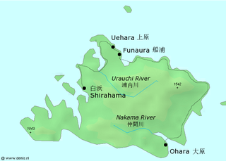
Iriomote Island is the largest of the Yaeyama Islands of Japan, and the second largest in Okinawa Prefecture after Okinawa Island itself.

Hatoma is a small island of the Yaeyama Islands, barely 1 kilometer in diameter. It is under the administration of Taketomi District, Okinawa Prefecture, Japan. In local language, the island's name is pronounced Patuma.

Hateruma is an island in the Yaeyama District of Okinawa Prefecture, Japan. Part of the town Taketomi, it is the southernmost inhabited island in Japan at 24°2’25" north latitude, 123°47’16" east longitude. Hateruma is one of the Yaeyama Islands, and is located 24 kilometres (15 mi) south of Iriomote-jima, the largest of the island group.

The Battle of Pungdo or Feng-tao was the first naval battle of the First Sino-Japanese War. It took place on 25 July 1894 off Asan, Chungcheongnam-do, Korea, between cruisers of the Imperial Japanese Navy and components of the Chinese Beiyang Fleet. Both China and Japan had been intervening in Korea against the Donghak Peasant Revolution. While China tried to maintain her suzerain relationship with Korea, Japan wanted to increase her sphere of influence.

The Ryukyu Islands, also known as the Nansei Islands or the Ryukyu Arc, are a chain of Japanese islands that stretch southwest from Kyushu to Taiwan: the Ōsumi, Tokara, Amami, Okinawa, and Sakishima Islands, with Yonaguni the westernmost. The larger are mostly high islands and the smaller mostly coral. The largest is Okinawa Island.

Yaeyama (八重山) was a small minelayer of the Imperial Japanese Navy, which was in service during the Second Sino-Japanese War and World War II primarily as an escort vessel. She was named after the Yaeyama Islands in the Ryukyu Islands chain. She was the first Japanese warship built with an all-welded hull.

USS Decker (DE-47) was an Evarts class destroyer escort constructed for the United States Navy during World War II. She was sent off into dangerous North Atlantic Ocean waters to protect convoys and other ships from German submarines and fighter aircraft. She performed escort and antisubmarine operations in battle areas before sailing home victorious at the end of the conflict.
The Ryūkyū brown frog is a species of true frog endemic to the Ryūkyū Islands, specifically Okinawa and perhaps neighboring islands.

The Kampira Falls frog, also known as the Yaeyama harpist frog or harpist brown frog, is a species in the true frog family (Ranidae). Until recently known as Rana psaltes, it is found on Ishigaki and Iriomote in the Yaeyama Islands of Japan, as well as on Taiwan.
Odorrana supranarina is a species of frog in the family Ranidae. It is endemic to Ryukyu Archipelago, Japan, and is known from the islands of Ishigaki and Iriomote, both in the Yaeyama Group. The specific name supranarina refers to the large size of this species —at the time of the species description, it was the largest member of the so-called Rana narina complex. Common name greater tip-nosed frog has been coined for it.
Odorrana utsunomiyaorum is a species of frog in the family Ranidae. It is endemic to Ryukyu Archipelago, Japan, and is known from the islands of Ishigaki and Iriomote, both in the Yaeyama Group. The specific name utsunomiyaorum honours Taeko and Yasuaki Utsunomiya for their contributions to clarifying the amphibian fauna of the Yaeyama Group.

Kohama Island is an island in the Yaeyama Islands group at the southwestern end of the Ryukyu Islands chain, and part of Taketomi, Yaeyama District, Okinawa Prefecture, Japan. The island has an area of 7.84 km2 (3.03 sq mi), with a surrounding area of 16.6 km2 (6.4 sq mi). The island is located about 25 minutes by ferry from Ishigaki Island, which is the transportation and business center of the Yaeyama Islands.
The 1792 Unzen earthquake and tsunami resulted from the volcanic activities of Mount Unzen on 21 May. This caused the collapse of the southern flank of the Mayuyama dome in front of Mount Unzen, resulting in a tremendous megatsunami, killing 15,000 people altogether. It was also called Shimabara erupted, Higo affected (島原大変肥後迷惑), since many people were killed by this tsunami in Higo.

Kayama Island is a small uninhabited island located in the Yaeyama Islands of Okinawa Prefecture, Japan. It situated 2 kilometers northeast of Kohama Island.
