Metro Transit is the primary public transportation operator in the Minneapolis–Saint Paul area of the U.S. state of Minnesota and the largest operator in the state. In 2023, the system had a ridership of 44,977,200, or about 142,700 per weekday as of the first quarter of 2024.

The T Line, formerly known as Tacoma Link, is a light rail line in Tacoma, Washington, part of the Link light rail system operated by Sound Transit. It travels 4.0 miles (6.4 km) and serves 12 stations between Tacoma Dome Station, Downtown Tacoma, and Hilltop. The line carried 934,724 total passengers in 2019, with a weekday average of over 3,100 boardings. Tacoma Link runs for nine to 18 hours per day, using streetcars at frequencies of 12 to 20 minutes.

The Minnesota Valley Transit Authority, also known by the acronym MVTA, is a public transportation agency that serves seven communities in the southern portion of the Minneapolis–Saint Paul metropolitan area. The agency provides fixed-route and demand-responsive transit within the service area of the communities and to select destinations in the region.

SouthWest Transit is a public transportation agency that is based in Eden Prairie, Minnesota. The agency was formed in 1986 when the southwest Minneapolis suburbs of Chaska, Chanhassen, and Eden Prairie chose to opt out of the Metropolitan Transit Commission transit system in accordance with Minnesota State Statutes. Under a joint powers agreement between the three cities, they created their own transit system, SouthWest Metro Transit. In 2023, the system had a ridership of 446,400, or about 1,400 per weekday as of the first quarter of 2024.

The Metro Red Line is a bus rapid transit line between the Twin Cities suburbs of Bloomington, Minnesota and Apple Valley, Minnesota. The Red Line travels primarily on Minnesota State Highway 77 and Cedar Avenue from the Apple Valley station in Apple Valley, north through Eagan, Minnesota, to the Mall of America station in Bloomington where it connects to the Metro Blue Line. The line has bus rapid transit elements including bus-only lanes, specially branded vehicles, transit signal priority, and dedicated stations.

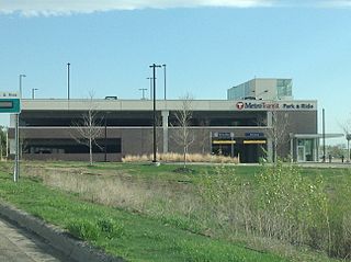
Burnsville Transit Station is a transit facility located in the vicinity of downtown Burnsville, Minnesota, and is the flagship station of the Minnesota Valley Transit Authority (MVTA). The station is the busiest park and ride location in the Twin Cities region and offers approximately 1,400 parking spaces. It is also a major transfer hub for routes operating the south of the Minnesota River. The station has indoor climate-controlled waiting, restrooms, lost and found, drinking fountains, vending machines, Go-To card sales, newspaper racks, and transit information. Due to high park and ride demand, MVTA moved some service to the 370 space Heart of the City public ramp about a 1⁄2 mile (0.80 km) south in 2018. The Metropolitan Council's 2021 park-and-ride system report found 267 cars parked at the station compared to 1,116 in 2019 before the COVID-19 pandemic.

The Metro Orange Line is a bus rapid transit line in the Twin Cities, Minnesota operated by Metro Transit. The line operates primarily along Interstate 35W from downtown Minneapolis through Richfield and Bloomington before terminating in Burnsville, Minnesota. The Orange Line provides access to 198,000 jobs with roughly a quarter of them outside downtown Minneapolis. The route serves a mix of stations located in the center of the highway, stations near highway exits, and on-street stations. The line has features typical of bus rapid transit systems with off-board fare payment, articulated buses with extra doors, stations with improved passenger amenities, and transit-only bus lanes on portions of the route.

Lynnwood Transit Center, also known as Lynnwood TC, is a bus station and future light rail station in Lynnwood, Washington. It is the largest transit hub in southwestern Snohomish County and is served by Community Transit and Sound Transit Express. The transit center also includes a parking garage with 1,670 spaces and bicycle facilities.

Kent station is a train station in the city of Kent, Washington, United States, served by the S Line of the Sounder commuter rail network. It is located in downtown Kent and consists of two train platforms connected via a pedestrian overpass, a parking garage, and several bus bays. The station also has 996 parking stalls and is served by King County Metro and Sound Transit Express buses. Train service to Kent began in 2001 and the station's garage opened the following year. King County Metro began service from the bus bays in 2005, after a third phase of construction. Sound Transit plans to build a second parking garage in 2027 to accommodate additional demand at the station.

Auburn station is a train station in the city of Auburn, Washington, United States, served by S Line of the Sounder commuter rail network. It is located southwest of downtown Auburn and consists of two train platforms, a bus station, a parking garage, a public plaza, and a pedestrian bridge. The station has 633 parking spaces and is also served by Sound Transit Express, King County Metro, and Pierce Transit buses. Auburn station opened in 2000 and was built on the site of a former railroad station that was demolished in 1979. The parking garage and pedestrian bridge opened in 2003, and a second parking garage is planned to be built by 2027.

Sumner station is a train station in the city of Sumner, Washington, United States. It is served by the S Line, a Sounder commuter rail line operated by Sound Transit. The station is located to the southwest of downtown Sumner and includes two platforms, a bus station, and 302 parking spaces. Commuter train service to Sumner began in September 2000 at a temporary station, while the permanent facility opened on March 10, 2001. Parking at the station is expected to expand to over 600 stalls in 2026, after the completion of a new parking garage and pedestrian bridge.

Puyallup station is a train station in the city of Puyallup, Washington, United States. It is served by the S Line, a Sounder commuter rail line operated by Sound Transit that runs from Pierce County to Seattle. The station is located northwest of downtown Puyallup and includes two platforms, several bus bays, and 640 parking spaces. Puyallup station opened on February 5, 2001, on the site of the city's original train depot, which was built in 1877 and demolished in 1974. The station's park and ride was expanded to 1,044 stalls in 2023 with the opening of a new parking garage. In addition to train service, the station is also served by Sound Transit Express and Pierce Transit buses that connect Puyallup to nearby cities.
The Kenrick Avenue Park and Ride is a 750-space parking ramp in Lakeville, Minnesota providing interchange for bus passengers.
Northwest Plano Park & Ride is a bus-only park and ride station in Plano, Texas. The station is located on the western side of Dallas North Tollway in Plano's Legacy Park neighborhood. The station is operated by Dallas Area Rapid Transit and is the northernmost facility in the DART system. Unlike most DART transit centers, the lot does not have an air-conditioned waiting area.

Lakewood station is a commuter rail station in Lakewood, Washington, United States. It is the terminus of the S Line of the Sounder commuter rail network, operated by Sound Transit in the Seattle metropolitan area. The station, located along Pacific Highway Southwest, includes a 620-stall parking garage and several bus bays served by Intercity Transit and Sound Transit Express. Lakewood station was originally scheduled to open in 2002 as part of a Sounder extension, but plans were delayed due to funding issues and the state government's work on the Point Defiance Bypass project. Construction on the $33 million station and garage began in March 2007 and it opened for use by buses on September 18, 2008. Sounder service to Lakewood began in October 2012 and the pedestrian bridge opened a few months later.

South Tacoma station is a commuter rail station in Tacoma, Washington, United States, served by the S Line of the Sounder commuter rail network. It is located near the Tacoma Mall along South Tacoma Way at South 56th Street and consists of a single platform and a 220-stall park-and-ride lot. Construction on the station began in early 2008 and the park-and-ride lot opened in February 2009, with service from a temporary express bus that operated until Sounder service began in October 2012.

Ramp A/7th Street Transit Center is a bus rapid transit station in downtown Minneapolis, Minnesota. The transit center is a southbound station on the Metro C Line and D Line, as well as several local routes. The transit center is located inside of Ramp A, a 3,637 stall parking ramp built over sunken Interstate 394.

Burnsville Heart of the City is a bus rapid transit station along the Metro Orange Line and its southern terminal. The station is located at the corner of Minnesota State Highway 13 in the downtown of Burnsville, Minnesota. The station is located between Minnesota Valley Transit Authority's (MVTA) Burnsville Transit Station and Heart of the City Park and Ride, providing bus connections and park and ride capacity.

The Marq2 transit corridor is a north–south thoroughfare in Minneapolis, Minnesota, United States. It consists of the parallel streets of Marquette and Second avenues in the downtown area. Each public streetway has two contraflow bus lanes with two lanes available for general-purpose traffic in the opposite direction. Vehicular transit flows south on Marquette Avenue and north on Second Avenue. The inner curb lane allows buses to stop for riders, while the second bus-only lane allows buses to pass each other along the corridor. Bus routes that operate on the corridor stop at every other block at an assigned gate with each route assigned a northbound and southbound gate. Gates are assigned letters A, B, C, or D on Marquette Avenue and E, F, G, and H on Second Avenue. Custom bus shelters are installed at each stop with heaters and real time transit information. The corridor primarily serves express buses operated by all five public transit agencies in the Twin Cities.

