
Africa is a continent comprising 63 political territories, representing the largest of the great southward projections from the main mass of Earth's surface. Within its regular outline, it comprises an area of 30,368,609 km2 (11,725,385 sq mi), excluding adjacent islands. Its highest mountain is Mount Kilimanjaro, its largest lake is Lake Victoria.

North America is a continent entirely within the Northern Hemisphere and almost all within the Western Hemisphere. It can also be described as a northern subcontinent of the Americas. It is bordered to the north by the Arctic Ocean, to the east by the Atlantic Ocean, to the southeast by South America and the Caribbean Sea, and to the west and south by the Pacific Ocean.

South America is a continent in the Western Hemisphere, mostly in the Southern Hemisphere, with a relatively small portion in the Northern Hemisphere. It can also be described as a southern subcontinent of the Americas. The reference to South America instead of other regions has increased in the last decades due to changing geopolitical dynamics.

The Nearctic is one of the eight biogeographic realms constituting the Earth's land surface.
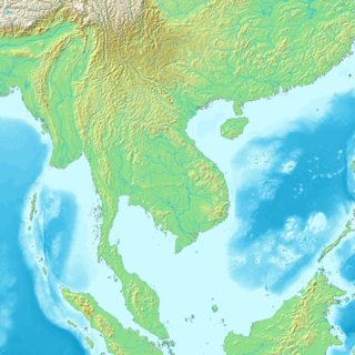
Mainland Southeast Asia is the continental portion of Southeast Asia. It lies east of the Indian subcontinent and south of China and is bordered by the Indian Ocean to the west and the Pacific Ocean to the east. It includes the countries of Cambodia, Laos, Myanmar (Burma), Peninsular Malaysia, Thailand and Vietnam.

The East Coast of the United States, also known as the Eastern Seaboard, the Atlantic Coast, and the Atlantic Seaboard, is the coastline along which the Eastern United States meets the North Atlantic Ocean. Regionally, the term refers to the coastal states and area east of the Appalachian Mountains that have shoreline on the Atlantic Ocean, from north to south, Maine, New Hampshire, Massachusetts, Rhode Island, Connecticut, New York, New Jersey, Delaware, Maryland, Virginia, North Carolina, South Carolina, Georgia, and Florida.

Northern Europe is a loosely defined geographical region in Europe. Narrower definitions may describe Northern Europe as being roughly north of the southern coast of the Baltic Sea, which is about 54°N, or may be based on other geographical factors such as climate and ecology. A broader definition would include the area of Europe north of the Alps.
Mainland is defined as "relating to or forming the main part of a country or continent, not including the islands around it [regardless of status under territorial jurisdiction by an entity]." The term is often politically, economically and/or demographically more significant than politically associated remote territories, such as exclaves or oceanic islands situated outside the continental shelf.
A subregion is a part of a larger region or continent and is usually based on location. Cardinal directions, such as south or southern, are commonly used to define a subregion.

Geography of Asia reviews geographical concepts of classifying Asia, the central and eastern part of Eurasia, comprising approximately fifty countries.

The Americas, also known as America, are lands of the Western Hemisphere, composed of numerous entities and regions variably defined by geography, politics, and culture.
The World Geographical Scheme for Recording Plant Distributions (WGSRPD) is a biogeographical system developed by the international Biodiversity Information Standards (TDWG) organization, formerly the International Working Group on Taxonomic Databases. The WGSRPD standards, like other standards for data fields in botanical databases, were developed to promote "the wider and more effective dissemination of information about the world's heritage of biological organisms for the benefit of the world at large". The system provides clear definitions and codes for recording plant distributions at four scales or levels, from "botanical continents" down to parts of large countries. Current users of the system include the International Union for Conservation of Nature (IUCN), the Germplasm Resources Information Network (GRIN), and the World Checklist of Selected Plant Families (WCSP).

Middle America is a subregion in the middle latitudes of the Americas. It usually comprises Clipperton Island, Mexico, the 7 countries of Central America, and the 13 countries and 19 territories of the West Indies. Together with Northern America, they form the continent of North America.

The boundaries between the continents of Earth are generally a matter of geographical convention. Several slightly different conventions are in use. The number of continents is most commonly considered seven but may range as low as four when the Americas and Afro-Eurasia are each considered a single continent. An island can be continental, and therefore associated with the continent on the same continental plate, or oceanic and associated with a continent or geographic region by convention.

A continent is one of several very large landmasses. Generally identified by convention rather than any strict criteria, up to seven regions are commonly regarded as continents. Ordered from largest in area to smallest, these seven regions are: Asia, Africa, North America, South America, Antarctica, Europe, and Australia. Variations with fewer continents may merge some of these, for example some systems include Eurasia or America as single continents.