Wressle is a village and civil parish in the East Riding of Yorkshire, England, lying on the eastern bank of the River Derwent approximately 3 miles (5 km) north-west of Howden.
Barlby is a linear village in the civil parish of Barlby with Osgodby, in North Yorkshire, England. It is situated 2 miles (3 km) to the north-east of the market town of Selby, and is bordered to the west by the River Ouse and to the east by the A19 Barlby bypass. Across the bypass is Barlby's smaller sister village, Osgodby.

Hemingbrough is a village and civil parish in North Yorkshire, England, approximately 5 miles (8 km) from Selby and 4 miles (6.4 km) from Howden on the A63. It was in the historic East Riding of Yorkshire, but since 1974 has come under North Yorkshire. The village has a 12th-century former collegiate church, a Methodist chapel and shops. There is a primary school and nursery. The surrounding area makes up part of the Humberhead Levels and is flat land, mainly used for mixed agriculture. In 2011 the parish had a population of 2020.

Cliffe is a small village and civil parish in Richmondshire district of North Yorkshire, England. A stream called the Glen runs through the village to the Tees. It is in the Teesdale and Yorkshire Dales national park. It is about 6 miles (10 km) west of Darlington, 10 miles (16 km) north of Richmond and near Piercebridge.

Lelley is a small village in the civil parish of Elstronwick, in the East Riding of Yorkshire, England, in an area known as Holderness. It is situated approximately 7 miles (11 km) north-east of Kingston upon Hull city centre and 3 miles (5 km) north of Hedon.

Lower Green Mill is a tower mill at Lower Green, located to the north of the village of Hindringham in the English county of Norfolk. The mill stands on the east side of the lane between Hindringham and Binham and is four miles east of Walsingham. The structure is a grade II listed building.
St Margaret's Bay Windmill is a Grade II listed smock mill on South Foreland, the southeasternmost point of England. It was built in 1929 to generate electricity for the attached house, high on the White Cliffs of Dover.
Skidby Windmill is a Grade II* listed windmill at Skidby near Beverley, in the East Riding of Yorkshire, England.

Cliffe is a small village and civil parish in North Yorkshire, England. It was historically part of the East Riding of Yorkshire until 1974, but from 1974 to 2023 was in the Selby District of the shire county of North Yorkshire. In 2023 the district was abolished and North Yorkshire became a unitary authority.

Tysoe is a civil parish in the Stratford-on-Avon District of Warwickshire, England. The parish is on the boundary with Oxfordshire, about 7+1⁄2 miles (12 km) northwest of Banbury. The parish includes the contiguous villages of Middle and Upper Tysoe and the separate hamlet of Lower Tysoe. The 2011 census recorded the parish population as 1,143.

Holgate Windmill is a tower mill at Holgate in York, North Yorkshire, England which has been restored to working order.
Marsh Mill is an 18th-century tower windmill in Thornton, Lancashire, England. It was built in 1794 by Ralph Slater for local landowner Bold Hesketh. It functioned as a corn mill until the 1920s and has been fully restored. It is a good example of a complete English windmill and has been designated a Grade II* listed building.

Little Marton Mill is a 19th-century English tower windmill in Marton, Blackpool, Lancashire, England. It was built in 1838 by John Hays for grinding corn, and worked until 1928. It has been designated a Grade II listed building by Historic England.

Steeton Hall Farm is a historic building in the civil parish of Steeton, North Yorkshire, south-west of York in England.

St John's Church is an Anglican church in Acaster Selby, a village south of York, in England.

The Old Windmill is a disused windmill in Appleton Roebuck, a village south-west of York in England.
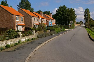
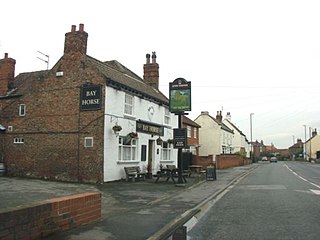
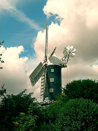
Cliffe is a civil parish in the former Selby district of North Yorkshire, England. It contains 14 listed buildings that are recorded in the National Heritage List for England. Of these, one is listed at Grade II*, the middle of the three grades, and the others are at Grade II, the lowest grade. The parish contains the villages of Cliffe and South Duffield and the surrounding countryside. Apart from a windmill, all the listed buildings are houses and associated structures.

Holmes House is a historic building in South Duffield, a village in North Yorkshire, in England.

Turnham Hall is a historic building in Cliffe, a village near Selby in North Yorkshire, in England.

Escrick Park is a historic building and country estate in Escrick, a village in North Yorkshire, in England.
