Pennsylvania Route 34 is a 62-mile-long (100 km) state route located in southern Pennsylvania. The southern terminus of the route is at U.S. Route 15 Business in Gettysburg. The northern terminus is at US 11/US 15 south of Liverpool. PA 34 heads north from Gettysburg through farmland in northern Adams County, passing through Biglerville. The route crosses South Mountain into Cumberland County and reaches Mount Holly Springs, where it intersects PA 94. PA 34 heads north into the agricultural Cumberland Valley and heads north to Carlisle, where it has an interchange with Interstate 81 (I-81) in the southern part of town and intersects US 11/PA 74/PA 641 in the downtown area. The route continues north through more rural land and crosses Blue Mountain into Perry County, where it continues through the Ridge-and-Valley Appalachians, winding north to New Bloomfield. From here, PA 34 continues northeast to Newport, where it crosses the Juniata River and reaches an interchange with US 22/US 322, before heading to its terminus at US 11/US 15 near the Susquehanna River.

Pine Grove Furnace State Park is a protected Pennsylvania area that includes Laurel and Fuller Lakes in Cooke Township of Cumberland County. The Park accommodates various outdoor recreation activities, protects the remains of the Pine Grove Iron Works (1764), and was the site of Laurel Forge (1830), Pine Grove Park (1880s), and a brick plant (1892). The Park is 8 miles (13 km) from exit 37 of Interstate 81 on Pennsylvania Route 233.

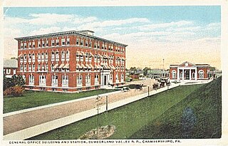
The Cumberland Valley Railroad was an early railroad in Pennsylvania, United States, originally chartered in 1831 to connect with Pennsylvania's Main Line of Public Works. Freight and passenger service in the Cumberland Valley in south central Pennsylvania from near Harrisburg to Chambersburg began in 1837, with service later extended to Hagerstown, Maryland, and then extending into the Shenandoah Valley to Winchester, Virginia. It employed up to 1,800 workers.

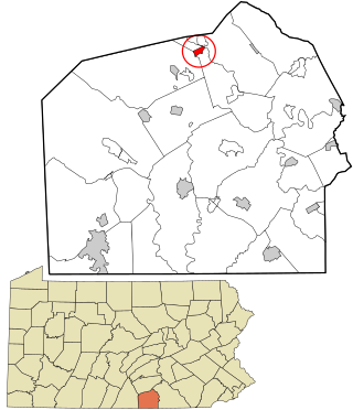
Gardners is an unincorporated community in Adams County, Pennsylvania and a census-designated place that includes portions of Adams and Cumberland counties in Pennsylvania, United States. The village of Gardners is located off Pennsylvania Route 34, in Tyrone Township, in northern Adams County. As of the 2020 census, the population of the village of Gardners was 137. The zip code for the United States Post Office in the village of Gardners is 17324. This zip code covers surrounding villages and areas in Adams and Cumberland counties, including Goodyear, Hunter's Run, Idaville, Pine Grove Furnace State Park, and Uriah.

The Round Top Branch was an extension of the Gettysburg and Harrisburg Railroad from the Gettysburg borough across the Gettysburg Battlefield to Round Top, Pennsylvania. The branch ran southward from the terminus of the railroad's main line, west of the school and St. Francis Xavier Cemetery, across the field of Pickett's Charge, south of Cemetery Ridge, east of Weikert Hill and Munshower Knoll, and through Round Top to a point between Little Round Top's east base and Taneytown Road. In addition to battlefield tourists, the line carried stone monoliths and statues for monuments during the battlefield's memorial association and commemorative eras and equipment, supplies and participants for Gettysburg Battlefield camps after the American Civil War.

The Gettysburg and Harrisburg Railroad was a railway line of Pennsylvania from Hunter's Run southward to Gettysburg in the 19th century. The north junction was with the South Mountain RR, and a crossing with the Hanover Junction, Hanover and Gettysburg Railroad's westward extension was at Gettysburg. The crossing also served as a junction for westbound trains to transfer southward across the Gettysburg Battlefield via the G. & H. R. R.'s Round Top Branch to the company's Little Round Top Park.

The Hunter's Run and Slate Belt Railroad was a railway line from the Hunter's Run junction of the Gettysburg and Harrisburg Railway that ran southwestward along the south side of Mountain Creek to the Pine Grove Iron Works. The line serviced facilities for mining, for manufacturing, and for recreation. Portions of the railbed are a section of the Appalachian Trail as well as the majority of the Cumberland County Biker/Hiker Trail and the entire "Old Railroad Bed Road" that is the southeast border of Pine Grove Furnace State Park.
Carlisle Junction may refer to:

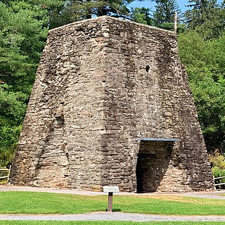
The Pine Grove Iron Works was a smelting facility in southcentral Pennsylvania during the Industrial Revolution. The works is notable for remaining structures that are historical visitor attractions of Pine Grove Furnace State Park, including the furnace stack of the Pine Grove Furnace. The site was listed on the National Register of Historic Places on April 13, 1977 for its significance in architecture and industry. It includes seven contributing buildings, two structures, fourteen sites, and two objects.
The South Mountain Iron Company was the owner of the Pine Grove Furnace in Cumberland County, Pennsylvania, along South Mountain after the 1864 $1,500,000 purchase from Jay Cooke & Company. In 1877 the company was split into separate mining and railway companies, with the latter South Mountain Railway and Mining Company establishing the 1884 South Mountain Railroad between the Pine Grove Iron Works and the Cumberland Valley Railroad's Carlisle Junction then being purchased by the 1891 Gettysburg and Harrisburg Railway company. The real estate of the 1877 South Mountain Mining and Iron Company is now the Pine Grove Furnace State Park and Michaux State Forest after being sold to the Pennsylvania Department of Forestry in 1912-3.

The Gettysburg and Harrisburg Railway was a Pennsylvania line from near Carlisle southward to Gettysburg operated by a subsidiary of the Reading Company. The line also included the Round Top Branch over the Gettysburg Battlefield to Round Top, Pennsylvania until c. 1942.

The Tapeworm Railroad was a railway line planned by Congressman Thaddeus Stevens and nicknamed by opponents ridiculing a lengthy serpentine section around the Green Ridge of South Mountain after an orator compared the path to a tapeworm depiction on a product's packaging. Switchbacks were planned on the west slope at Hughs Forge along the E Br Antietam Creek and on the east slope at Stevens' 1822 Maria Furnace along Toms Creek, with three east slope tunnels through spurs of Jacks Mountain.

The Pine Grove Railroad Station was the end of the line for the 1870 South Mountain Railroad, which transported materials from limestone pits and three operating ore mines for the Pine Grove Iron Works. The station had a roundhouse and, by 1872, a depot with siding "Pine Grove" was listed on the Gettysburg and Harrisburg Railroad's passenger schedule of April 21, 1884; and the SMRR railroad offices and repair shops were transferred to the 1891 Hunter's Run and Slate Belt Railroad with the station servicing the 1892 Fuller Brick and Slate Company south of the tracks Despite a 1902 forest fire in the area that destroyed buildings, both "Pine Grove Furnace" and "Pine Grove Park" were listed as 1904 HR & SB RR railway stations, and in 1912 new Reading Company track was laid to Pine Grove on "the former Hunters Run and Slate Belt Line". The Pine Grove area was sold to the Commonwealth of Pennsylvania in 1913, the tracks and ties have been removed, and the station area is part of the Pine Grove Furnace State Park.
Laurel Lake — also known as Laurel Forge Pond — is a water body with recreation area at Pine Grove Furnace State Park. It is located in the eastern part of Cooke Township, Cumberland County.
The Nichol's Gap Road was a central Pennsylvania highway established in the 18th century near Maryland, extending westward from the Black's Gap Road "just west of Little Conewago Creek" at the Crofs Keys stand of James Black. The road went past both the Rock Creek Church and the 1761 Samuel Gettys tavern where Gettysburg would be surveyed in 1786. The highway was built over South Mountain via Nichol's Gap and down the Devils Racecourse into the Cumberland Valley, allowing access to Hagerstown, Maryland. Called the "Hagerstown Road" during the Battle of Gettysburg, parts of the road are now designated (east-to-west): U.S. Route 30, Pennsylvania Route 116, Iron Springs Road, Gum Springs Road, and Old Route 16.

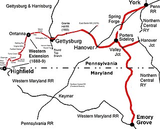
The Western Extension is a Western Maryland section of railway line between Highfield-Cascade, Maryland, and Gettysburg, Pennsylvania. The extension of the Hanover Junction, Hanover and Gettysburg Railroad westward from the Gettysburg Battlefield to Marsh Creek was completed in 1884, crossing the north-south Gettysburg and Harrisburg Railroad and its 1884 Round Top Branch in the borough The line was completed to Orr Station by June 30, 1885, then after an 1886 merger formed the Baltimore and Harrisburg Railway, the 15 mi (24 km) to the mainline at Highland near the Mason–Dixon line was completed in 1888-1889. The B&H leased their line to the Western Maryland Railway until the WM purchased it in 1917. The Western Extension used portions of the 1830s Tapeworm Railroad bed and required construction of the Jacks Mountain Tunnel south of Maria Furnace.
Pine Grove Park was an excursion park on the South Mountain Railroad line. It was located in Cumberland County, Pennsylvania, "in a grove of magnificent trees". It was established by Colonel Jackson C. Fuller c. 1881. It operated from c. 1881 to c. 1904.

The Letort Spring Run Nature Trail (LSRNT) is a rail trail in Carlisle, Pennsylvania. The trail stretches between Carlisle Borough's Letort Park and a trailhead approximately 2 miles (3.2 km) south at South Spring Garden Street. It parallels and twice crosses the Letort Spring Run, a limestone stream nationally recognized for its role in fly fishing heritage. The trail is an expression of the Letort Regional Authority's mission to promote appreciation of the Letort, as well as to protect the stream, greenway, and watershed from degradation.

The Gettysburg and Northern Railroad is a short-line railroad located in the U.S. state of Pennsylvania. The railroad operates a 25-mile (40 km) long line running between Gettysburg in Adams County and Mount Holly Springs in Cumberland County.


