
The South Shore is a geographical term applied to the area in the New York City borough of Staten Island, south and east of the island's ridge of hills along the waterfront and adjacent areas from the Narrows to the mouth of the Arthur Kill. Many observers prefer to restrict its scope to the neighborhoods located between the shoreline of Raritan Bay on one side and Richmond Creek and Fresh Kills on the other, thus encompassing the neighborhoods of Great Kills to Tottenville only. Those who use this narrower definition of the "South Shore" prefer the term "East Shore" for the communities that lie along Lower New York Bay, and inland for approximately 2 to 2+1⁄2 miles, from Bay Terrace and Richmondtown to as far north as Grasmere and Concord. The South Shore is represented in the New York City Council by Joe Borelli.

Mariners Harbor is a neighborhood located in the northwestern part of New York City's borough of Staten Island. It is bordered by Lake Avenue to the east, Forest Avenue to the south, Richmond Terrace to the north, and Holland Avenue to the west. The northwestern section of Mariners Harbor is often known as Arlington.
Prince's Bay is the name of a neighborhood located on the South Shore of New York City's borough of Staten Island. Prince's Bay is bordered to the north by Huguenot, to the south by the Raritan Bay, and to the west by Pleasant Plains. The neighborhood is represented in the New York State Senate by Andrew Lanza, in the New York State Assembly by Michael Reilly, and in the New York City Council by Joe Borelli.

Charleston is a neighborhood, or section, of New York City's borough of Staten Island. It is located on the island's South Shore, with Tottenville to the south, Pleasant Plains to the East, Rossville to the north, and the Arthur Kill to the west. The neighborhood is represented in the New York City Council by Joe Borelli and in the New York State Senate by Andrew Lanza.
West Shore refers to the section of the New York City borough of Staten Island that borders the Arthur Kill, between the Staten Island Expressway and the Fresh Kills. The Arthur Kill shoreline north of the expressway—most commonly called Port Ivory—is considered part of the North Shore, while the land along the Arthur Kill south of Fresh Kills is generally included within the South Shore.

Pleasant Plains is a neighborhood located on Staten Island, New York City, New York. It is bordered by Woodrow to the north, the Lower New York Bay to the south, Richmond Valley to the west, and Prince's Bay to the east. The neighborhood is represented in the New York City Council by Joe Borelli.

Richmond Valley is the name of a neighborhood located on the South Shore of Staten Island, one of the five boroughs of New York City, the largest city in the United States. Richmond Valley is bordered on the north by Pleasant Plains, to the south by Tottenville, to the west by the Arthur Kill, and to the east by the Lower New York Bay.
Westerleigh is a residential neighborhood in the north-western part of Staten Island in New York City.
Graniteville is the name of a neighborhood in Staten Island, one of the five boroughs of New York City.

Concord is a neighborhood located in the borough of Staten Island in New York City, New York, United States.
Lighthouse Hill is the name of a hill, and the neighborhood situated thereon, in the New York City borough of Staten Island. Lighthouse Hill is situated to the north of Richmondtown, south of Todt Hill, and west of Grant City.
Elm Park is the name of a small park in the Port Richmond section of Staten Island, one of the five boroughs of New York City, United States. The park is located across Innis Street from Port Richmond High School.

Tottenville High School is located at 100 Luten Avenue, in Huguenot, Staten Island, New York. Tottenville H.S. is in Administrative District 31, and is operated by the New York City Department of Education. The school's principal is Gina Battista, who assumed the role in 2020.
Arthur Kill Correctional Facility was a medium security correctional facility on Arthur Kill Road in Charleston, Staten Island, New York City. It operated from 1976 to 2011, run by what was then the New York State Department of Correctional Services. The prison had a capacity of 931 male inmates.

Staten Island University Hospital (SIUH) is a member hospital of Northwell Health. It is a major tertiary referral center in Staten Island, New York City.

Old Town is a neighborhood in the New York City borough of Staten Island, located on its East Shore. Old Town was established in August 1661 as part of New Netherland, and was the first permanent European settlement on Staten Island. Originally described as "Oude Dorpe", much of its original territory makes up what is present-day South Beach, with parts of Midland Beach and Dongan Hills. The area was settled by a group of Dutch, Walloon and French Protestants (Huguenots) led by Walloon Pierre Billiou.
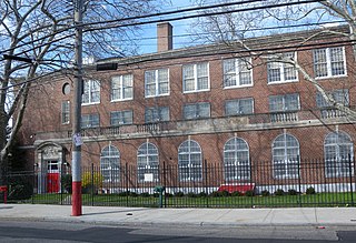
Port Richmond High School is a public high school on the North Shore of Staten Island, New York City, New York. It is located in the Elm Park neighborhood, at 85 St Josephs Avenue between Innis Street and Charles Avenue. It has approximately 100 full-time teachers and a student-to-teacher ratio of 21.5.

Arthur Kill Road is a major northeast-southwest artery along the South-West Shore of the New York City borough of Staten Island. It is 8.54 miles (13.74 km) long, and runs through the neighborhoods of Tottenville, Richmond Valley, Charleston, Rossville, Woodrow, Huguenot, Arden Heights, Annadale, Eltingville, Greenridge, Great Kills, and Richmondtown.

The Augustinian Academy on Staten Island, New York, was founded on May 30, 1899, in conjunction with the new Roman Catholic parish of Our Lady of Good Counsel, both by the Augustinian Friars. The academy expanded in 1926 and closed in 1969, adding about 250 priests to the Augustinian order.

