South Seas

Last updated

Today the term South Seas, or South Sea, most commonly refers to the portion of the Pacific Ocean south of the equator. [1] [2] [3] The term South Sea may also be used synonymously for Oceania, or even more narrowly for Polynesia or the Polynesian Triangle, an area bounded by the Hawaiian Islands, New Zealand and Easter Island. Pacific Islanders are commonly referred to as South Sea Islanders, particularly in Australia.

Contents

The term was first coined as Mar de Sur, or “South Sea,”  by Spanish conquistador Vasco Núñez de Balboa in 1513 and was applied to the entire area of today's Pacific Ocean. In 1520, Ferdinand Magellan named the same ocean the Pacific Ocean, and over time Magellan's name became more well-known.

Origin

Vasco Nunez de Balboa Nunez de Balboa.jpg
Vasco Núñez de Balboa

The Spanish conquistador Vasco Núñez de Balboa coined the term "South Sea" when he traveled across the Isthmus of Panama and reached the Bay of San Miguel, naming the ocean ahead Mar del Sur ("South Sea") due to its location along the southern shore of the isthmus. [4]

Spain claimed the South Sea as its mare clausum during the Age of Discovery. Iberian mare clausum claims.svg
Spain claimed the South Sea as its mare clausum during the Age of Discovery.

Núñez de Balboa and his soldiers attempted to travel to the peak of the mountain to see the sea, but when they arrived at the foot of the mountain only 69 out of 190 soldiers had survived the journey. Balboa did not want to share the experience of being the first to see the unknown ocean and so he commanded his crew to remain at the foot of the mountain and wait. He then became the first European to see the Pacific Ocean on 25 September 1513. After looking at the ocean alone for some time, he told his crew to come up to join him. [3] [4]

After he set foot into the ocean, at the opening of the Saban river he declared the South Sea, and all adjoining lands to be property of his king. [4]

Literature and film

A genre of literature and film has developed around the South Seas because it is often seen as an idealized and romanticized region of the world.

In 1773, when James Cook came to Tahiti for the second time, he was accompanied by Johann Reinhold Forster and Georg Forster, two German scientists.

"What a morning—impossible to be described more beautifully by any poet—when we saw the isle O-Taheiti two miles ahead of us."

The reports of the discoveries determined the Europeans' picture of the South Seas for a long time. On those grounds, Joseph Banks wrote:

"An Arcadia of which we will be king."

Louis Antoine de Bougainville's romantic travel report Voyage autour du monde and Georg Forster's travel description A Voyage Round the World (1777) confirmed Jean-Jacques Rousseau's image of the "noble savage". He describes the country as "jardin d’Eden" (Garden of Eden), which provided his residents with everything required to live. He saw the islanders as pure humans who were not yet poisoned by civilization. The report Voyage autour du monde inspired Denis Diderot to write his essay Supplément au voyage de Bougainville , a plea for sexual freedom.

Paul Gauguin, a French artist, contributed to the idea of a Garden of Eden by creating paintings of exotic paradises rather than as they really were.

The German writer Erich Scheurmann also utilized this imagery when he created fictional travel reports of a South Seas chief that were published between 1915 and 1920 under the title The Papalagi . The book gained popularity fifty years after it was published and sold more than 1.7 million copies in German alone.

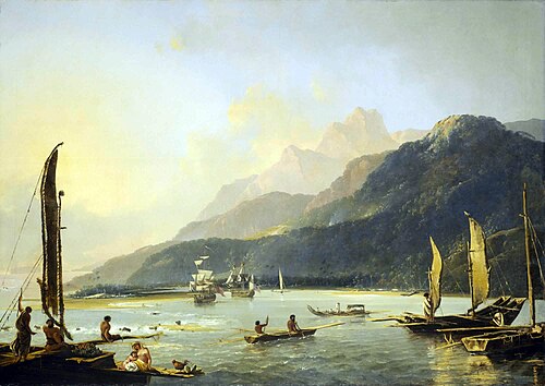
Drawings and paintings

Joseph Banks hired Sydney Parkinson, a nature draftsman, and Alexander Buchan, landscape painter, to accompany James Cook's first expedition to the Pacific (1768 –1771) and to record the discoveries that were made. Parkinson and Buchan  depicted the people living on the Society Islands, the coasts of New Zealand, and on Easter Island and their environments  in drawings and paintings. The painter William Hodges accompanied Captain Cook on his second expedition to the South Seas, New Zealand, Tonga, the Society Islands, Melanesia, and Easter Island among others. During Cook's third expedition to the South Seas, John Webber painted South Sea motifs on the Cook Islands, Tahiti and Hawaii, among other places.

Paul Gauguin reached Tahiti in April 1891 and painted 66 paintings during his time there. He left the island in early 1892 due to health problems and brief difficulties and later returned to Paris to travel to Papeete in September 1895. He died in 1903 on the Marquesas.

Gauguin is considered a pioneer of Expressionism because of his South Sea paintings. Other artists that traveled to areas within the South Seas include Emil Nolde,Max Pechstein, Henri Matisse, Per Kirkeby, and most recently artist Ingo Kühl.

Other usages of the term "South Seas"

The South Seas Mandate was the name of the Japanese mandate over certain islands following World War I.

The "South Seas trade" was a term used in Britain in the nineteenth century to denote sealing, whaling, island trading and other commercial ship-based activities in the Pacific.

See also

Related Research Articles

<span class="mw-page-title-main">History of Oceania</span>

The history of Oceania includes the history of Australia, Easter Island, Fiji, Hawaii, New Zealand, Papua New Guinea, Western New Guinea, and other Pacific island nations.

<span class="mw-page-title-main">James Cook</span> British explorer, cartographer and naval officer (1728–1779)

Captain James Cook was a British explorer, cartographer and naval officer famous for his three voyages between 1768 and 1779 in the Pacific Ocean and to New Zealand and Australia in particular. He made detailed maps of Newfoundland prior to making three voyages to the Pacific, during which he achieved the first recorded European contact with the eastern coastline of Australia and the Hawaiian Islands and the first recorded circumnavigation of New Zealand.

<span class="mw-page-title-main">Pacific Ocean</span> Ocean between Asia, Oceania, and the Americas

The Pacific Ocean is the largest and deepest of Earth's five oceanic divisions. It extends from the Arctic Ocean in the north to the Southern Ocean in the south, and is bounded by the continents of Asia and Oceania in the west and the Americas in the east.

<span class="mw-page-title-main">Tahiti</span> Island in French Polynesia

Tahiti is the largest island of the Windward group of the Society Islands in French Polynesia. It is located in the central part of the Pacific Ocean and the nearest major landmass is Australia. Divided into two parts, Tahiti Nui and Tahiti Iti, the island was formed from volcanic activity; it is high and mountainous with surrounding coral reefs. Its population was 189,517 in 2017, making it by far the most populous island in French Polynesia and accounting for 68.7% of its total population; the 2022 Census recorded a population of 191,779.

<span class="mw-page-title-main">Pacific Islander</span> Person from the Pacific Islands

Pacific Islanders, Pasifika, Pasefika, Pacificans or rarely Pacificers are the peoples of the Pacific Islands. As an ethnic/racial term, it is used to describe the original peoples—inhabitants and diasporas—of any of the three major subregions of Oceania.

<span class="mw-page-title-main">Louis Antoine de Bougainville</span> French admiral and explorer

Louis-Antoine, Comte de Bougainville was a French admiral and explorer. A contemporary of the British explorer James Cook, he took part in the Seven Years' War in North America and the American Revolutionary War against Britain. Bougainville later gained fame for his expeditions, including a circumnavigation of the globe in a scientific expedition in 1763, the first recorded settlement on the Falkland Islands, and voyages into the Pacific Ocean. Bougainville Island of Papua New Guinea as well as the Bougainvillea flower are named after him.

<span class="mw-page-title-main">Tuamotus</span> Archipelago in French Polynesia

The Tuamotu Archipelago or the Tuamotu Islands are a French Polynesian chain of just under 80 islands and atolls in the southern Pacific Ocean. They constitute the largest chain of atolls in the world, extending over an area roughly the size of Western Europe. Their combined land area is 850 square kilometres. This archipelago's major islands are Anaa, Fakarava, Hao and Makemo.

<span class="mw-page-title-main">Apataki</span> Atoll in French Polynesia

Apataki is a coral atoll in the South Pacific Ocean, territorially part of French Polynesia. It is one of the Palliser Islands, a subgroup of the Tuamotu Archipelago. Apataki is located approximately 370 kilometres northeast of the island of Tahiti, 17 km (11 mi) east of Arutua and 24 km (15 mi) northeast of Kaukura. The island is approximately rectangular; it is 34 km (21 mi) long and 24 km (15 mi) wide. It has a total area of approximately 706 km2 with a land area of approximately 21 km2 (8 sq mi). Two navigable passes enter its wide lagoon.

<span class="mw-page-title-main">Vasco Núñez de Balboa</span> Spanish explorer, governor, and conquistador (c. 1475 – 1519)

Vasco Núñez de Balboa was a Spanish explorer, governor, and conquistador. He is best known for crossing the Isthmus of Panama to the Pacific Ocean in 1513, becoming the first European to lead an expedition to have seen or reached the Pacific from the New World.

<span class="mw-page-title-main">Society Islands</span> Archipelago in French Polynesia

The Society Islands are an archipelago in the South Pacific Ocean that includes the major islands of Tahiti, Moʻorea, Raiatea, Bora Bora and Huahine. Politically, they are part of French Polynesia, an overseas country of the French Republic. Geographically, they form part of Polynesia.

David Henry Lewis was a sailor, adventurer, doctor, and scholar of Polynesian culture. He is best known for his studies on the traditional systems of navigation used by the Pacific Islanders. His studies, published in the book We, the Navigators, made these navigational methods known to a wide audience and helped to inspire a revival of traditional voyaging methods in the South Pacific.

<span class="mw-page-title-main">Polynesian navigation</span> Methods to navigate the Pacific Ocean

Polynesian navigation or Polynesian wayfinding, which was relearned through Micronesians, was used for thousands of years to enable long voyages across thousands of kilometres of the open Pacific Ocean. Polynesians made contact with nearly every island within the vast Polynesian Triangle, using outrigger canoes or double-hulled canoes. The double-hulled canoes were two large hulls, equal in length, and lashed side by side. The space between the paralleled canoes allowed for storage of food, hunting materials, and nets when embarking on long voyages. Polynesian navigators used wayfinding techniques such as the navigation by the stars, and observations of birds, ocean swells, and wind patterns, and relied on a large body of knowledge from oral tradition. This island hopping was a solution against the scarcity of useful resources, such as food, wood, water, and available land, on the small islands in the Pacific Ocean. When an island’s required resources for human survival began to run low, the island's inhabitants used their maritime navigation skills and set sail for a new island full of possibilities. However, as an increasing number of islands in the South Pacific became occupied, and citizenship and national borders became of international importance, this was no longer possible. People thus became trapped on islands with the inability to support them.

Early Polynesian explorers reached nearly all Pacific islands by 1200 CE, followed by Asian navigation in Southeast Asia and the West Pacific. During the Middle Ages, Muslim traders linked the Middle East and East Africa to the Asian Pacific coasts, reaching southern China and much of the Malay Archipelago. Direct European contact with the Pacific began in 1512, with the Portuguese encountering its western edges, soon followed by the Spanish arriving from the American coast.

<span class="mw-page-title-main">Second voyage of James Cook</span> 1772–75 British maritime voyage

The second voyage of James Cook, from 1772 to 1775, commissioned by the British government with advice from the Royal Society, was designed to circumnavigate the globe as far south as possible to finally determine whether there was any great southern landmass, or Terra Australis. On his first voyage, Cook had demonstrated by circumnavigating New Zealand that it was not attached to a larger landmass to the south, and he charted almost the entire eastern coastline of Australia, yet Terra Australis was believed to lie further south. Alexander Dalrymple and others of the Royal Society still believed that this massive southern continent should exist. After a delay brought about by the botanist Joseph Banks' unreasonable demands, the ships Resolution and Adventure were fitted for the voyage and set sail for the Antarctic in July 1772.

<span class="mw-page-title-main">James Cook Collection: Australian Museum</span>

The Australian Museum's Cook Collection was acquired in 1894 when it was transferred from the Government of New South Wales. At that time it consisted of 115 artifacts collected on Captain James Cook's three voyages of discovery Throughout the Pacific Ocean, during the period 1768–1780, along with documents and memorabilia related to these voyages. Many of the ethnographic artifacts were collected at a time of first contact between Pacific Peoples and Europeans. In 1935 most of the documents and memorabilia were transferred to the Mitchell Library in the State Library of New South Wales. The provenance of the collection shows that the objects remained in the hands of Captain James Cook's widow, Mrs Elizabeth Cook and her descendants until 1886. In this year Mr John Mackrell, the great nephew of Isaac Smith, Elizabeth Cook's cousin, organized the display of this collection at the request of the NSW Government at the Colonial and Indian Exhibition in London. In 1887 the London-based Agent-General for the New South Wales Government, Saul Samuel, bought John Mackrell's items and also acquired those items belonging to the other relatives Reverend Canon Frederick Bennett, Mrs Thomas Langton, H.M.C.Alexander and Mr William Adams. The collection remained with the Colonial Secretary of NSW until 1894, when it was transferred to the Australian Museum.

Matavai Bay is a bay on the north coast of Tahiti, the largest island in the Windward group of French Polynesia. It is in the commune of Mahina, approximately 8 km east of the capital Pape'ete.

<i>Merahi metua no Tehamana</i> Painting by Paul Gauguin

Merahi metua no Tehamana is an 1893 painting by the French artist Paul Gauguin, currently in the collection of the Art Institute of Chicago. The painting is a portrait of Paul Gauguin's wife Teha'amana during his first visit to Tahiti in 1891–1893. This marriage has always provoked controversy because it was arranged and completed in the course of a single afternoon and Gauguin claimed Teha'amana was just thirteen years old at the time.

<i>Arii Matamoe</i> Painting by Paul Gauguin

Arii Matamoe or The Royal End is a painting on coarse cloth by the French artist Paul Gauguin, created in 1892 during the painter's first visit to Tahiti. It depicts a man's severed head on a pillow, displayed before mourners, and although it did not depict a common or contemporary Tahitian mourning ritual, may have been inspired by the death of Pōmare V in 1891 shortly after Gauguin's arrival. A curator for the J. Paul Getty Museum suggested Gauguin likely painted the canvas "to shock Parisians" upon his expected return to the city.

<span class="mw-page-title-main">Tahitian Dog</span> Extinct Polynesian dog breed

The Tahitian Dog is an extinct breed of dog from Tahiti and the Society Islands. Similar to other strains of Polynesian dogs, it was introduced to the Society Islands and Tahiti by the ancestors of the Tahitian (Mā’ohi) people during their migrations to Polynesia.

<i>A Voyage Round the World</i> Work by Georg Forster

A Voyage Round the World is Georg Forster's report on the second voyage of the British explorer James Cook. During the preparations for Cook's voyage, the expedition's naturalist Joseph Banks had withdrawn his participation, and Georg's father, Johann Reinhold Forster, had taken his place at very short notice, with his seventeen-year-old son as his assistant. They sailed on HMS Resolution with Cook, accompanied by HMS Adventure under Tobias Furneaux. On the voyage, they circumnavigated the world, crossed the Antarctic Circle and sailed as far south as 71° 10, discovered several Pacific islands, encountered diverse cultures and described many species of plants and animals.

References

  1. Spate, O. H. K. (1977). "'South Sea' to 'Pacific Ocean': A Note on Nomenclature". The Journal of Pacific History. 12 (4): 205–211. JSTOR   25161059 . Retrieved 21 March 2023.
  2. "South of What?". Mapping Sovereignty. Duke University. Retrieved 21 March 2023.
  3. 1 2 Maroto Camino, Mercedes (2005). Producing the Pacific: Maps and Narratives of Spanish Exploration (1567-1606). Brill. p. 76. ISBN   9789401202923 . Retrieved 21 March 2023.
  4. 1 2 3 Polk, Dora Beale (1991). The Island of California: A History of The Myth (1995 reprint ed.). Spokane, Washington: Arthur H. Clark Company. pp. 67–76. ISBN   0-8032-8741-0.