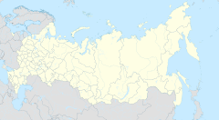
Ingush, historically known as Durdzuks, Gligvi and Kists, are a Northeast Caucasian ethnic group mainly inhabiting the Republic of Ingushetia in central Caucasus, but also inhabitanting Prigorodny District and town of Vladikavkaz of modern day North-Ossetia. The Ingush are predominantly Sunni Muslims and speak the Ingush language.
John the Exarch was a medieval Bulgarian scholar, writer and translator, one of the most important men of letters working at the Preslav Literary School at the end of the 9th and the beginning of the 10th century. He was active during the reign of Boris I and his son Simeon I. His most famous work is the compilation Shestodnev that consists of both translations of earlier Byzantine authors and original writings. The Russian Orthodox Church canonized him and his memory is honoured on the 13 August [O.S. 31 July]. In a manuscript of the Gospels, held in the National Library of Serbia, an alternative date is given, namely — 13 February [O.S. 31 January].

The Shoana church is a Christian church that belongs to the historical Alanian Diocese. The church was built at the end of the tenth century, and is located on the territory of modern Karachay-Cherkessia Republic, Russia. The building has a crossed-dome plan, with an inscribed cross, which is a variation of the North Zelenchuk Church.
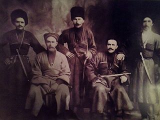
The Orstkhoy, historically commonly known under their exonyms: Karabulaks, Balsu, Baloy, are a historical ethnoterritorial society among the Chechen and Ingush peoples. Their homeland is in the upper reaches of the Assa and Fortanga rivers in the historical region of Orstkhoy-Mokhk. In the tradition of the Chechen ethno-hierarchy, it is considered one of the nine historical Chechen tukkhums, in the Ingush tradition as one of the seven historical Ingush shahars.
The Mamilovs are an Ingush tribal organization/clan (teip). The clan comprises about 1,500 people. It is one of a few Ingush clans whose members share one name.

Simsim was either a historical region or kingdom in the North Caucasus during the Middle Ages, existing in the 14th century. Predominantly localized roughly in eastern Chechnya (Ichkeria), with some also connecting part of Kumyk Plain. Simsim is also localized in both Chechnya and Ingushetia. Its name may have been derived from the Chechen village of Simsir. However, according to folklore, the King Gayur-khan was chosen as the leader of all Chechens by the Mehk-Khel. In its later years it allied itself with the Golden Horde before being destroyed in 1395 by Timurlane, which was recorded in Zafarnama by Nizam al-Din Shami and the Zafarnama by Sharaf ad-Din Ali Yazdi.
Mark Mendelevich Persits was a Soviet propagandist of atheism, a scientific worker in the study of problems of religion and atheism, a writer, and a historian of social thought.

Central Zelenchuchsky Church is an Alanian church, located in the Lower-Arkhyz settlement in Russia's Karachay-Cherkessia Republic. It is the oldest church in this settlement.
Semyon Alekseyevich Kamenev was an educator, professor, writer, and Soviet propagandist of atheism.
Gligvi is a medieval ethnonym used in Georgian, Russian and Western European sources in the 16th-19th centuries. The ethnonym corresponds to the self-name of the Ingush, Ghalghaï.

Fappi or Fappi mokhk, exonym: Kistetia, is a historical region in Ingushetia. Fappi is the territory of historical settlement of the Fyappiy society.

Galashians, were a historical Ingush ethnoterritorial society, which formed in the middle of the 18th century. The name comes from the village of Galashki, which is geographically located in the very center of the society. Galashians were located in the middle and lower reaches of the river Assa and the basin of the river Fortanga.
The Nazranians were a historical Ingush ethnoterritorial subethnic group (society) which inhabited modern day Nazranovsky District and Prigorodny District.

The Dzherakh, also spelled Jerakh, historically also known as Erokhan people, were a historical Ingush ethnoterritorial society, today a tribal organization/clan (teip), that was formed in the Dzheyrakhin gorge, as well as in the area of the lower reaches of the Armkhi River and the upper reaches of the Terek River.

Khamkhins, also known as Ghalghaï, were a historical Ingush ethnoterritorial society, which was located in the upper reaches of the Assa River. The Khamkhin society, like the Tsorin society, was formed from the former "Ghalghaï society" as a result of the transfer of rural government to Khamkhi.
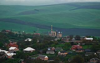
Ekazhevo is a rural locality in Nazranovsky District of the Republic of Ingushetia, Russia. It forms the municipality of the rural settlement of Ekazhevo as the only settlement in its composition.

Surkhakhi is a rural locality in Nazranovsky District of the Republic of Ingushetia, Russia. It forms the municipality of the rural settlement of Surkhakhi as the only settlement in its composition.

Targim is an ancient city-settlement in the Dzheyrakhsky District of Ingushetia. It is part of the rural settlement of Guli. The entire territory of the settlement is included in the Dzheyrakh-Assa State Historical-Architectural and Natural Museum-Reserve and is under state protection.

Bryk, is a mesa, a butte in Andropovsky District, Stavropol Krai, Russia, a complex geological and geomorphological natural monument of regional significance. Since 2013, it has been included in the list of Protected areas of Russia of regional significance in Stavropol Krai.
Saray-Gora, Saray Gora, Saray-gora, Saraygora is a mountain in the Caucasus, orographically belonging to the Skalisty Range, which extends along the northern slope of the Greater Caucasus system. It is located in the Tuapsinsky District of Krasnodar region, east of the village of Sadovoye. It is characterized as a low mountain with its height 772.3 m or 772.6 m above sea level. It is the highest point of the Skalisty Range in the Psekups river basin. The number on the State Catalog of Geographical Names is 0160784. In the orographic systematics of the Russian Empire period it belonged to the so-called Black Mountains.