Southampton homestead

Last updated

Southampton homestead
Southampton Homestead 2006.jpg
Southampton Homestead in 2006
Australia Western Australia location map.svg
Red pog.svg
Southampton homestead
Location of Southampton homestead in Western Australia
General information
Type Station
Location Balingup, Western Australia
Coordinates 33°53′17″S115°58′19″E / 33.888°S 115.972°E / -33.888; 115.972 (Southampton homestead) Coordinates: 33°53′17″S115°58′19″E / 33.888°S 115.972°E / -33.888; 115.972 (Southampton homestead)
Reference no. 710

Southampton homestead is a Victorian-Georgian historical homestead located on the banks of the Blackwood River in the south west of Western Australia.

Contents

It was constructed in 1862 by Richard Jones(1795-1876) and his two sons Richard and William with mud-bricks fired on the site and took two years to construct. The heritage property sits beside the Bibbulmun Track, and located some 12 km (7.5 mi) south of Balingup in the Shire of Donnybrook-Balingup.

At the height of the settlement's prosperity, the Jones family managed some 27,500 acres (111 km2) of land. The family and workers produced wine, wheat, fruit and ran 600 head of cattle. Infrastructure included the Homestead proper, kitchen/bakery, flour mill, Dairy, workshops, brick kilns, jetty, boat shed and workers cottages.

The homestead was destroyed by a bushfire in February 2013. [1]

History

Southampton Homestead was so named after the United Kingdom Port of Southampton near which settlers Richard Jones and his wife Louisa and their five children sailed on the Lotus from Portsmouth in 1829 to pursue opportunities in the new Swan River colony of Perth, Western Australia. Arriving in 1829, the Joneses originally purchased a property on the corner of St Georges Terrace and Barrack Street in the city of Perth.

Southampton Homestead as painted by W.B. Benson in 1864 Southampton Homestead 1864 William Benson Painting.jpg
Southampton Homestead as painted by W.B. Benson in 1864

Tragedy struck in 1830 when Louisa became the first European woman to die in the new colony, succumbing during childbirth at the age of 29. The baby boy, Joseph, died 3 months after his mother. They are both buried in the historic East Perth Cemetery. This left Richard Jones a widower with five children. He subsequently engaged the services of a housekeeper, a Malaysian man John Allum, who remained in the service of the family for the next 40 years. John Allum died at the age of 83 and is buried on the hill behind the homestead overlooking the Blackwood Valley.

Richard Thomas Jones 1822-1903 Richard Thomas Jones.JPG
Richard Thomas Jones 1822-1903

Richard sold his city-central piece of real estate for 8,000 pounds in 1855 to purchase 10 acres (40,000 m2) of newly released land on the Blackwood River South of Balingup with his two sons Richard and William on which they built a wattle and daub homestead. This first homestead was dramatically flooded by the Blackwood River the next winter in 1860. Its location was only recently discovered during archaeological investigations in June 2007.

Richard and Louisa Jones' daughter Mary Ann c.1880 Mary Ann McHard.JPG
Richard and Louisa Jones' daughter Mary Ann c.1880

Richard and Louisa's Daughter Mary McHard (1826-1912) was widowed when her husband was killed in an industrial accident in Perth in 1864. Mary brought her four daughters with her to live on the property in 1864. Her four daughters produced the only direct descendants, who live in the Perth and the Southwest region of Western Australia.

William James Jones 1823-1906 William James Jones.JPG
William James Jones 1823-1906

Richard Jones spent the remainder of his life at the Homestead with his two sons (William and Richard) and daughter Mary and her children. Neither of his sons married and hence there was no heir. He died aged 81 in 1876 and the sons and daughter continued working on the property. William, Richard Jr, and Mary remained on the property until as late as 1903. It was in this year that, on suffering depression from his failing health and eyesight, William took his own life.

Ownership of Southampton Homestead changed hands a number of times in the next 50 years, falling into disrepair and being procured by the Forest's Department in 1960. Extensive pine plantations of Pinus radiata were then established. The property was largely forgotten for the next 30 years until its heritage qualities were identified and the site slated for restoration in the late 1990s.

During a storm in February 2013, lightning strikes started a severe bushfire in the area. Driven by strong SW winds, the fire swept through the valley in which the homestead was situated and - despite firefighters' best efforts - razed it. [2]

Archaeology

A team of 15 archaeologists from the University of Western Australia and University of Notre Dame Australia and the Archaeological Society of WA surveyed the site as part of Phase 2 of the Conservation Plan commissioned by the Western Australian Heritage Council. Excavations in June 2007 began an historical and forensic investigation of the Heritage site. Outcomes of the investigation were the identification of the site of the original 1860 Homestead and the site of the Mill, approximately 2.7 kilometres south of the homestead. Of the seven buildings originally on the site, the archaeological survey goals are to identify the location, role and fabric of some of these buildings. There still remains only rudimentary evidence of most of them.

Heritage

Southampton Mill as painted by W.B. Benson in 1864 Southampton Mill painting W Benson 1864.jpg
Southampton Mill as painted by W.B. Benson in 1864

The property is highly valued by the local community and the government. It was recently awarded a triple-heritage listing with Local, State and Federal Australian government. The Conservation Plan outlines a three-phase program. Phase 1 focused on the salvage and restoration of Southampton Homestead and adjacent Bakery Cottage. This work was largely complete by 2002. The homestead is typical of mid-19th century constructions and no early restoration work appears to have been attempted. This would have damaged or altered the building's fabric, as was typical in this region in the latter half of the 20th century. The building's fabric is preserved as a result of this.

Southampton circa 1895. "Western Australia; The Garden of the Colony. Bunbury, Busselton, Bridgetown & c" Frontis Southampton 1895.JPG
Southampton circa 1895. "Western Australia; The Garden of the Colony. Bunbury, Busselton, Bridgetown & c"

Related Research Articles

<span class="mw-page-title-main">Augusta, Western Australia</span> Town in Western Australia

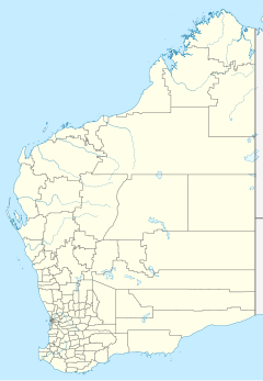
Augusta is a town on the south-west coast of Western Australia, where the Blackwood River emerges into Flinders Bay. It is the nearest town to Cape Leeuwin, on the furthest southwest corner of the Australian continent. In the 2001 census it had a population of 1,091; by 2016 the population of the town was 1,109.

Captain John Molloy was an early Irish settler in Western Australia. He was one of the original settlers of Augusta and an early settler of Busselton.

Dunsborough is a coastal town in the South West of Western Australia, 254 kilometres (158 mi) south of Perth, on the shores of Geographe Bay.

<span class="mw-page-title-main">Balingup, Western Australia</span> Town in Western Australia

Balingup is a town in the South West of Western Australia, 241 kilometres (150 mi) south of the state capital, Perth, and 31 kilometres (19 mi) southeast of the town of Donnybrook.

<span class="mw-page-title-main">Boyup Brook, Western Australia</span> Town in Western Australia

Boyup Brook is a town in the south-west of Western Australia, 269 kilometres (167 mi) south-southeast of Perth and 31 kilometres (19 mi) northeast of Bridgetown. The town lies on Kaniyang land within the Noongar nation.

<span class="mw-page-title-main">Kirup, Western Australia</span> Town in Western Australia

Kirup, originally named Upper Capel, then Kirupp, is situated between Donnybrook and Balingup on the South Western Highway, 228 kilometres (142 mi) south of Perth, Western Australia in the upper reaches of the Capel River valley.

<span class="mw-page-title-main">Blackwood River</span> River in Western Australia

The Blackwood River is a major river and catchment in the South West of Western Australia.

<span class="mw-page-title-main">Nannup, Western Australia</span> Town in the South West region of Western Australia

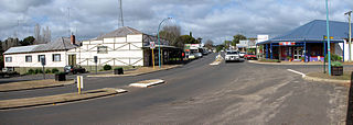
Nannup is a town in the South West region of Western Australia, approximately 280 kilometres (174 mi) south of Perth on the Blackwood River at the crossroads of Vasse Highway and Brockman Highway; the highways link Nannup to most of the lower South West's regional centres. At the 2011 census, Nannup had a population of 587.

<span class="mw-page-title-main">Shire of Donnybrook–Balingup</span> Local government area in the South West region of Western Australia

The Shire of Donnybrook Balingup is a local government area in the South West region of Western Australia, about 35 kilometres (22 mi) southeast of Bunbury and about 220 kilometres (137 mi) south of the state capital, Perth. The Shire covers an area of about 1,560 square kilometres (602 sq mi), and its seat of government is the town of Donnybrook.

<span class="mw-page-title-main">Lanyon Homestead</span> Historic house museum in the Australian Capital Territory

Lanyon is an historic homestead and grazing property located on the southern outskirts of Canberra in the Australian Capital Territory.

<span class="mw-page-title-main">Wesley Church, Perth</span> Church in Perth, Western Australia

Wesley Church is a Uniting Church in Perth, Western Australia, located at the corner of William Street and Hay Street. It is one of the oldest church buildings and one of few remaining 19th-century colonial buildings in the City of Perth.

<span class="mw-page-title-main">Louisa Downs Station</span> Pastoral lease in Western Australia

Louisa Downs, also commonly just referred to as "Louisa", is a large cattle station midway between Fitzroy Crossing and Halls Creek in the Kimberley region in Western Australia.

<span class="mw-page-title-main">Robert John Sholl</span> British colonial settler in Western Australia

Robert John Sholl was a government administrator, magistrate, explorer, journalist, entrepreneur, harbourmaster, customs official, postmaster and lay reader in Western Australia (WA), during the colonial era. Because of his multiple, simultaneous roles, which carried judicial, political, cultural and commercial power and influence, Sholl is regarded as a significant figure in the history of North-West Australia, at an early stage of its settlement by Europeans.

<span class="mw-page-title-main">Gwambygine Homestead</span> Homestead in York, Western Australia

Gwambygine Homestead is one of the earliest colonial buildings still remaining in Western Australia. Until the death in 1998 of the last occupant, Merton Clifton, the house had the reputation of being the oldest continually occupied house in the state.

Charles Samuel Brockman was a prominent explorer and pastoralist in the Gascoyne region of Western Australia.

Mount Welcome Station is a pastoral lease that once operated as a sheep station but is now operated as a cattle station in Western Australia.

<span class="mw-page-title-main">Mulga Downs Station</span> Pastoral lease in Western Australia

Mulga Downs Station is a pastoral lease that once operated as a sheep station but is currently operating as a cattle station in Western Australia.

<span class="mw-page-title-main">Bon Marché Arcade</span> Heritage listed building in Perth, Western Australia

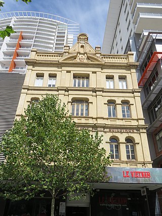
Bon Marché Arcade, also known as Bon Marché Buildings, is a heritage-listed building in Perth, Western Australia], located at 74–84 Barrack Street in the Perth central business district. It is three and four storeys tall, built in 1901 from brick in the Federation Free Classical architectural style, with a tin roof. Designed by architect H. J. Prockter, it was a prominent feature in Barrack Street when constructed, being taller than the one or two story buildings surrounding it.

<span class="mw-page-title-main">Mary Ann McHard</span> Botanical collector for F. von Mueller in WA (1825 - 1912)

Mary Ann McHard (1825–1912), née Jones, was a pioneering Western Australian woman who contributed to Australian botany by collecting over 2000 plant specimens for Ferdinand von Mueller and sending them to the newly created National Herbarium of Victoria.

<span class="mw-page-title-main">Mamre (homestead)</span> Homestead in New South Wales, Australia

Mamre is a heritage-listed former farm homestead complex, grain cropping, pastoral property and wool production and now residence, community facility, market gardening and nursery production located at Mamre Road in the western Sydney suburb of Orchard Hills in the City of Penrith local government area of New South Wales, Australia. It was built from 1822 to 1832. The property is owned by the New South Wales Department of Planning and Infrastructure. It was added to the New South Wales State Heritage Register on 2 April 1999.

References

  1. "Southampton Homestead lost as bushfires torch the South-West". news.com.au. 14 February 2013. Retrieved 16 February 2013.
  2. "Southampton Homestead destroyed by bushfire". ABC News. 14 February 2013. Retrieved 14 February 2013.