Related Research Articles

Barbour County is a county in the southeastern part of the U.S. state of Alabama. As of the 2020 census, the population was 25,223. Its county seat is Clayton. Its largest city is Eufaula. Its name is in honor of James Barbour, who served as Governor of Virginia.

Cherokee County, Alabama is a county located in the northeastern part of the U.S. state of Alabama. As of the 2020 census, the population was 24,971. Its county seat is Centre. The county is named for the Cherokee tribe.

Geneva County is a county located in the southeastern part of the U.S. state of Alabama. As of the 2020 census, the population was 26,659. Its county seat is Geneva. The county was named after its county seat, which in turn was named after Geneva, New York which was named after Geneva, Switzerland, by Walter H. Yonge, an early town resident and Swiss native. Geneva County is a dry county. However, beer and wine are sold in the city limits of Geneva, Samson, Slocomb, and most recently in Hartford, after residents voted to become wet in a 2022 election.

Henry County is a county in the southeastern part of the U.S. state of Alabama. As of the 2020 census, its population was 17,146. Its county seat is Abbeville. The county was named for Patrick Henry (1736–1799), famous orator and Governor of Virginia.
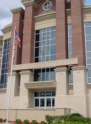
Houston County is a county located in the southeastern corner of the U.S. state of Alabama. As of the 2020 census the population was 107,202. Its county seat is Dothan, which is located on the border and partially in adjacent Henry County.
Carroll County is a county located in the northwestern part of the State of Georgia. As of the 2020 census, its population was 119,148. Its county seat is the city of Carrollton. Carroll County is included in the Atlanta–Sandy Springs–Roswell metropolitan statistical area and is also adjacent to Alabama on its western border.

Ashland is a city in Clay County, Alabama, United States. The population was 2,037 at the 2010 census. The city is the county seat of Clay County.

Ozark is a city in and the county seat of Dale County, Alabama. As of the 2010 census, the population of the city was 14,907.
Rainsville is a city in DeKalb County, Alabama, United States. At the 2010 census the population was 4,948, up from 4,499 in 2000. Rainsville is located on top of Sand Mountain, a southern extension of the Cumberland Plateau.
Geneva is a city in and the county seat of Geneva County, Alabama, United States. It was incorporated in 1875. It is part of the Dothan, Alabama Metropolitan Statistical Area. Since 1940, it has been the largest city of Geneva County, and had a population of 4,292 as of the 2020 census.
Headland is the largest city in Henry County, Alabama, United States. It is part of the Dothan metropolitan area. In 2020, the population was 4,973, up from 4,510 in the 2010 census.

Cottonwood is a town in Houston County, Alabama, United States. One source said the town incorporated in 1901, although the 1910 U.S. Census stated 1903. It is part of the Dothan, Alabama Metropolitan Statistical Area. At the 2010 census the population was 1,289, up from 1,170 in 2000. The area was heavily damaged by an EF2 tornado on January 9, 2024. One person was killed and five others were injured.

Franklin is a city in Heard County, Georgia, United States. The population was 950 in 2020. Franklin is the county seat of Heard County. The city is named after Benjamin Franklin.

Anson is a city in and the county seat of Jones County, Texas, United States. The population was 2,294 at the 2020 census. It is part of the Abilene, Texas metropolitan area. Originally named "Jones City", the town was renamed "Anson" in 1882 in honor of Anson Jones, the last president of the Republic of Texas.

The Wiregrass region, also known as the Wiregrass plains or Wiregrass country, is an area of the Southern United States encompassing parts of southern Georgia, southeastern Alabama, and the Florida Panhandle. The region is named for the native Aristida stricta, commonly known as wiregrass due to its texture.
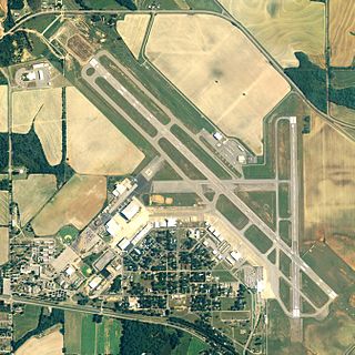
Dothan Regional Airport is a public airport in Dale County, Alabama, United States, seven miles northwest of Dothan, a city mostly in Houston County.

Urzainqui is a town and municipality located in the province and autonomous community of Navarre, northern Spain. According to the 2017 census, there are 85 inhabitants in the area.
South Alabama and Lower Alabama are overlapping, poorly-defined terms for various parts of southern Alabama. Although it is not a strictly defined geographic region, it generally includes all Alabama counties south of the Black Belt. In that view, South Alabama consists of just the two counties that border the Gulf of Mexico and Mobile Bay: Baldwin County and Mobile County. That area is characterized by extensive wetlands, but also by long, sandy beaches which are very conducive to tourism. Many deluxe golf courses have been developed in the area in recent decades.

Area code 334 is a telephone area code in the North American Numbering Plan (NANP) for southeastern Alabama. It was created on January 15, 1995, in an area code split from area code 205. It was the first new area code in Alabama since the announcement of the area code system in 1947. To permit a transition period for the reconfiguration of equipment, such as computers and fax machines, use of area code 205 continued in the 334 region through May 13, 1995.
Pedro Bank is a large bank of sand and coral, partially covered with seagrass, about 80 km south and south-west of Jamaica, rising steeply from a seabed of 800 m depth.
References
- ↑ Alerts, Advance Local Weather (2024-10-08). "Update: Tropical cyclone statement issued for Southeast Alabama until Tuesday midday". al. Retrieved 2024-10-08.
- ↑ "What Southeast Alabama, Southwest Georgia, and the Big Bend Area of Florida Can Expect Overnight : The Alabama Weather Blog". www.alabamawx.com. Retrieved 2024-10-08.
31°50′N85°57′W / 31.833°N 85.950°W
| | This Alabama state location article is a stub. You can help Wikipedia by expanding it. |