Southeast Kentucky floods of 2020

Last updated

Major flooding inundated Southeast Kentucky from February 6-7, 2020, as the result of an extremely heavy rain event. [1]

Contents

Twenty one counties in Eastern Kentucky sustained flood damage, and Kentucky Governor Andy Beshear declared a state of emergency on February 8, for Bell, Clay, Harlan, Knox, Leslie, Letcher, Perry and Whitley Counties. [2] [3] [4]

Flooding timeline

Beginning on February 3, numerous rounds of rainfall began to impact eastern Kentucky. This continued through February 7th, highlighted by heavy rainfall from the evening of February 5th through the first half of February 6th. Rain amounts of 4-6 inches fell across much of southeastern Kentucky over this period. This led to major flooding and numerous mudslides across portions of Whitley, Perry, Letcher, Leslie, Knox, Harlan, Clay, and Bell Counties. The Governor subsequently declared a State of Emergency for these 8 counties.

Major flooding occurred along the Cumberland River at Pineville, Barbourville, and Williamsburg. Additionally, the communities of Loyall and Baxter experienced major flooding. Numerous roads became impassable across large portions of Whitley, Knox, Clay, Leslie, Letcher, Harlan, Perry, and Bell counties. In particular, Harlan County was hit extremely hard with the Kentucky Mesonet site on Black Mountain (4031 foot elevation) receiving over 6.5 inches of rain over this stretch.

Flood gates were closed in Pineville and Harlan, further impacting local travel. [5] A couple of mobile homes were flooded and swept down the Cumberland River in Harlan County, while swift water rescues took place in Bell and Harlan Counties. Elkhorn Dam in Jenkins had water rushing over it for a period of time on February 6. [3] A man went missing in Whitley County and was later found deceased in his car on Kentucky Highway 779 after his attempt to drive into flood waters. A total of seven homes were reported to have been in or under water across Whitley County as the Cumberland River in Williamsburg crested to its third highest stage on record of 34.84 feet. The city of Pineville saw the river rise to its second highest crest in history at 1019.06 feet, leading to several families being stranded without homes.

While impacts were greatest along the Cumberland River, several portions of the Kentucky River also flooded. Several roads were impacted in Hazard and Whitesburg, while Booneville, Heidelberg, and Ravenna also exceeded flood stage. Along the Levisa Fork of the Big Sandy River, the city of Pikeville hit flood stage and closed its flood gates.

During the first two weeks of February, "more than eight inches of water fell, causing the Cumberland and Kentucky Rivers to reach their highest levels in 40 years." [6]

Relief efforts

By February 18, Kentucky Baptist Disaster Relief workers were preparing for "mud-outs" (assisting with cleaning mud out of damaged houses) in Harlan, Bell, Knox and Whitley counties." [7] On February 19, $500,000 in grant money was announced for flood cleanup, to ensure "environmentally responsible disposal of solid waste." [8] The Atlantic Magazine noted that this flood has received little attention at the national level, and that there has been no national relief effort. [6]

See also

Related Research Articles

<span class="mw-page-title-main">Bell County, Kentucky</span> County in Kentucky, United States

Bell County is a county located in the southeast part of the U.S. state of Kentucky. As of the 2020 census, the population was 24,097. Its county seat is Pineville and its largest city is Middlesboro. The county was formed in 1867, during the Reconstruction era from parts of Knox and Harlan counties and augmented from Knox County in 1872. The county is named for Joshua Fry Bell, a US Representative. It was originally called "Josh Bell", but on January 31, 1873, the Kentucky legislature shortened the name to "Bell",

<span class="mw-page-title-main">Cumberland River</span> River in Kentucky and Tennessee, United States

The Cumberland River is a major waterway of the Southern United States. The 688-mile-long (1,107 km) river drains almost 18,000 square miles (47,000 km2) of southern Kentucky and north-central Tennessee. The river flows generally west from a source in the Appalachian Mountains to its confluence with the Ohio River near Paducah, Kentucky, and the mouth of the Tennessee River. Major tributaries include the Obey, Caney Fork, Stones, and Red Rivers.

<span class="mw-page-title-main">National Register of Historic Places listings in Kentucky</span>

This is a list of properties and historic districts in Kentucky that are listed on the National Register of Historic Places. There are listings in all of Kentucky's 120 counties.

The Kentucky State Police Division of Commercial Vehicle Enforcement (CVE), commonly known in the Commonwealth as Kentucky Vehicle Enforcement (KVE), is a statewide law enforcement agency for the Commonwealth of Kentucky. The Division employs both sworn officers and civilian commercial vehicle inspectors. CVE's primary purpose is the enforcement of all state laws/regulations on commercial and non commercial vehicles traveling throughout the Commonwealth of Kentucky. CVE's secondary purpose is to conduct drug interdiction operations on the Commonwealth's state and county highways, working jointly with the KSP's Special Operations Division D.E.S.I. unit. The CVE Division operates and monitors the Commonwealth's system of commercial vehicle weigh stations throughout Kentucky. Their headquarters is located in Frankfort.

<span class="mw-page-title-main">National Register of Historic Places listings in Warren County, Kentucky</span>

This is a list of the National Register of Historic Places listings in Warren County, Kentucky.

<span class="mw-page-title-main">National Register of Historic Places listings in Barren County, Kentucky</span>

This is a list of the National Register of Historic Places listings in Barren County, Kentucky.

<span class="mw-page-title-main">National Register of Historic Places listings in Campbell County, Kentucky</span>

This is a list of the National Register of Historic Places listings in Campbell County, Kentucky.

<span class="mw-page-title-main">National Register of Historic Places listings in Whitley County, Kentucky</span>

This is a list of the National Register of Historic Places listings in Whitley County, Kentucky.

<span class="mw-page-title-main">National Register of Historic Places listings in Muhlenberg County, Kentucky</span>

This is a list of the National Register of Historic Places listings in Muhlenberg County, Kentucky.

<span class="mw-page-title-main">National Register of Historic Places listings in Knox County, Kentucky</span>

This is a list of the National Register of Historic Places listings in Knox County, Kentucky.

<span class="mw-page-title-main">National Register of Historic Places listings in Ballard County, Kentucky</span>

This is a list of the National Register of Historic Places listings in Ballard County, Kentucky.

<span class="mw-page-title-main">National Register of Historic Places listings in Bath County, Kentucky</span>

This is a list of the National Register of Historic Places listings in Bath County, Kentucky.

<span class="mw-page-title-main">National Register of Historic Places listings in Bell County, Kentucky</span>

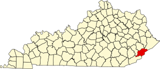
This is a list of the National Register of Historic Places listings in Bell County, Kentucky.

<span class="mw-page-title-main">National Register of Historic Places listings in Clay County, Kentucky</span>

This is a list of the National Register of Historic Places listings in Clay County, Kentucky.

<span class="mw-page-title-main">National Register of Historic Places listings in Cumberland County, Kentucky</span>

This is a list of the National Register of Historic Places listings in Cumberland County, Kentucky.

<span class="mw-page-title-main">National Register of Historic Places listings in Harlan County, Kentucky</span>

This is a list of the National Register of Historic Places listings in Harlan County, Kentucky.

<span class="mw-page-title-main">National Register of Historic Places listings in Leslie County, Kentucky</span>

This is a list of the National Register of Historic Places listings in Leslie County, Kentucky.

<span class="mw-page-title-main">National Register of Historic Places listings in Letcher County, Kentucky</span>

This is a list of the National Register of Historic Places listings in Letcher County, Kentucky.

<span class="mw-page-title-main">National Register of Historic Places listings in Menifee County, Kentucky</span>

This is a list of the National Register of Historic Places listings in Menifee County, Kentucky.

<span class="mw-page-title-main">National Register of Historic Places listings in Perry County, Kentucky</span>

This is a list of the National Register of Historic Places listings in Perry County, Kentucky.

References

  1. Latek, Tom (February 7, 2020). "8 Kentucky counties under states of emergency from flooding". Kentucky Today. Retrieved 2020-02-24.
  2. Associated Press (February 7, 2020). "Bad weather moves into Eastern states causing flooding; 5 dead in South". The Courier-Journal. Retrieved 2020-02-24.
  3. 1 2 Boles, Sydney (2020-02-07). "States of Emergencies Declared Amid Eastern Kentucky Floods". Ohio Valley ReSource. Retrieved 2020-02-24.
  4. "Gov. Beshear declares state of emergency in response to flooding". Wave 3 News. 2020-02-08. Retrieved 2020-02-24.
  5. Cox, Erin (Feb 9, 2020). "UPDATED: Cumberland River crests in Williamsburg as flooding records set throughout area". The Times-Tribune. Retrieved 2020-02-24.
  6. 1 2 House, Silas (2020-02-23). "Eastern Kentucky Has Been Underwater, but You Probably Didn't Notice". The Atlantic. Retrieved 2020-02-24.
  7. Maynard, Mark (2020-02-18). "Kentucky Disaster Relief Responds to In-State Flooding". Word&Way. Retrieved 2020-02-24.
  8. Associated Press (February 19, 2020). "Grants Available to Help Counties Clean up From Floods". U.S. News & World Report. Retrieved 2020-02-24.

PD-icon.svg This article incorporates public domain material from Major Flooding Inundates Southeast Kentucky Followed by Light Snow From February 6-7, 2020. National Oceanic and Atmospheric Administration.