Related Research Articles

Martin State Airport is a joint civil-military public use airport located nine nautical miles east of the central business district of Baltimore, in Baltimore County, Maryland, United States. The facility is located within the census-designated place of Middle River on Maryland State Highway 150, near the intersection of Maryland State Highway 700. The Maryland Aviation Administration operates the airport on behalf of the Maryland Department of Transportation. MTN is a general aviation relief airport.
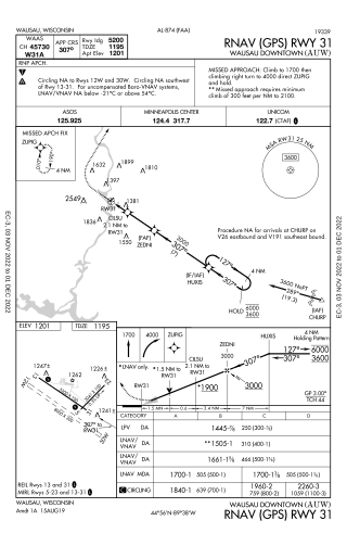
Wausau Downtown Airport is a city-owned public-use airport located in Wausau, a city in Marathon County, Wisconsin, United States. The airport serves general aviation aircraft, charter flights and seaplane operations. It is included in the Federal Aviation Administration (FAA) National Plan of Integrated Airport Systems for 2021–2025, in which it is categorized as a local general aviation facility.

Lake Hood Seaplane Base is a state-owned seaplane base located three nautical miles (6 km) southwest of the central business district of Anchorage in the U.S. state of Alaska. The Lake Hood Strip is a gravel runway located adjacent to the seaplane base. The gravel strip airport's previous code of has been decommissioned and combined with as another landing surface.

Iliamna Airport is a state-owned public-use airport located three nautical miles (5.5 km) west of the central business district of Iliamna, in the Lake and Peninsula Borough of the U.S. state of Alaska.

Bettles Airport is a state-owned public-use airport located in Bettles, a city in the Yukon-Koyukuk Census Area of the U.S. state of Alaska.
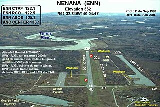
Nenana Municipal Airport is a city-owned public-use airport located one mile (1.6 km) south of the central business district of Nenana, a city in the Yukon-Koyukuk Census Area of the U.S. state of Alaska.

Ketchikan Harbor Seaplane Base is a privately owned, public use seaplane base located at the harbor of Ketchikan, a city in the Ketchikan Gateway Borough of the U.S. state of Alaska. It is located near the Ketchikan International Airport, which also has its own seaplane landing area. Prior to the opening of the Ketchikan International Airport in 1973, scheduled passenger seaplane service was operated with amphibian aircraft between the seaplane base and the Annette Island Airport located approximately 20 miles south, as this land plane airfield previously served as the primary airport for Ketchikan, with scheduled airline flights being operated by Pan American World Airways, Pacific Northern Airlines and Western Airlines into Annette Island over the years.
Sky Harbor Airport & Seaplane Base or Sky Harbor Airport is a public airport in Duluth, Minnesota, United States. It is located near the Wisconsin border, between Superior Bay and Lake Superior. The airport is six nautical miles (11 km) southeast of the central business district of Duluth, Minnesota, on Minnesota Point within its city limits.
Baudette International Airport is a county-owned public-use airport located one mile (2 km) north of the central business district of Baudette, a city in Lake of the Woods County, Minnesota, United States. Also known as Baudette International Airport & Seaplane Base, it is located on the Rainy River, which is the border between Minnesota in the U.S. and Ontario in Canada.
Old Town Municipal Airport and Seaplane Base, also known as Dewitt Field, is a public use airport located two nautical miles (4 km) northwest of the central business district of Old Town, in Penobscot County, Maine, United States. It is owned by the City of Old Town. The seaplane base is located on Marsh Island on the Penobscot River.
Tower Municipal Airport is a city-owned public-use airport located one nautical mile (2 km) northwest of the central business district of Tower, a city in Saint Louis County, Minnesota, United States. It is located on Lake Vermilion and is also known as Tower Municipal Airport & Seaplane Base.
Maple Lake Municipal Airport is a city-owned, public-use airport located one nautical mile (2 km) northeast of the central business district of Maple Lake, a city in Wright County, Minnesota, United States. It is located on Maple Lake and is also known as Maple Lake Municipal Airport & Seaplane Base. The current full name is now Maple Lake Municipal - Bill Mavencamp Sr Field.
Harlan County Lake Seaplane Base is a public use seaplane base located six nautical miles (11 km) southwest of the central business district of Alma, a city in Harlan County, Nebraska, United States. It is owned by the U.S. Army Corps of Engineers.
Nunapitchuk Airport is a state-owned public-use airport located in Nunapitchuk, a city in the Bethel Census Area of the U.S. state of Alaska.
Trident Basin Seaplane Base is a city-owned, public-use seaplane base located in the City of Kodiak, in the Kodiak Island Borough of the U.S. state of United States. This seaplane base is located 4 nautical miles (7 km) northeast of the Kodiak Airport.
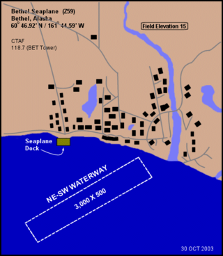
Bethel Seaplane Base is a public use seaplane base located on the Kuskokwim River in Bethel, a city in the Bethel Census Area of the U.S. state of Alaska.
Shannons Pond Seaplane Base is a public-use seaplane base located three nautical miles west of the central business district of Dillingham, a city in the Dillingham Census Area of the U.S. state of Alaska. As per Federal Aviation Administration records, this facility had 1,000 passenger boardings (enplanements) in calendar year 2008. It is 3 miles (5 km) west of Dillingham Airport.
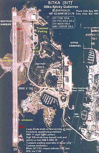
Sitka Seaplane Base is a public use seaplane base owned by and located in Sitka, a city and borough in the U.S. state of Alaska. It is included in the National Plan of Integrated Airport Systems for 2011–2015, which categorized it as a general aviation facility. This seaplane base is located near the Sitka Rocky Gutierrez Airport.
Beaver Lake Seaplane Base is a state owned, public use seaplane base located four nautical miles northeast of Big Lake, in the Matanuska-Susitna Borough of the U.S. state of Alaska.
Polson Airport is a public use airport in Lake County, Montana, United States. It is located one nautical mile (2 km) west of the central business district of Polson, a city on the southern shore of Flathead Lake. The airport is owned by the City of Polson and Lake County. It is included in the National Plan of Integrated Airport Systems for 2011–2015, which categorized it as a general aviation facility.
References
- 1 2 3 FAA Airport Form 5010 for 65LA PDF , effective 2008-09-25.
- ↑ Airport information for BCS at Great Circle Mapper.