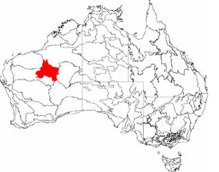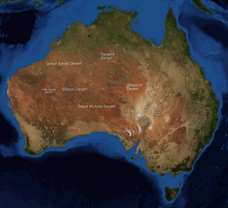
The Great Sandy Desert is an interim Australian bioregion, located in the northeast of Western Australia straddling the Pilbara and southern Kimberley regions and extending east into the Northern Territory. It is the second largest desert in Australia after the Great Victoria Desert and encompasses an area of 284,993 square kilometres (110,036 sq mi). The Gibson Desert lies to the south and the Tanami Desert lies to the east of the Great Sandy Desert.

The Warlpiri, sometimes referred to as Yapa, are a group of Aboriginal Australians defined by their Warlpiri language, although not all still speak it. There are 5,000–6,000 Warlpiri, living mostly in a few towns and settlements scattered through their traditional land in the Northern Territory, north and west of Alice Springs (Mparntwe). About 3,000 people still speak the Warlpiri language. The word "Warlpiri" has also been romanised as Walpiri, Walbiri, Elpira, Ilpara, and Wailbri.
The Central Land Council (CLC) is a land council that represents the Aboriginal peoples of the southern half of the Northern Territory of Australia (NT), predominantly with regard to land issues. it is one of four land councils in the Northern Territory, and covers the Central Australia region. The head office is located in Alice Springs.

The Little Sandy Desert (LSD) is a desert region in the state of Western Australia, lying to the east of the Pilbara and north of the Gascoyne regions. It is part of the Western Desert cultural region, and was declared an interim Australian bioregion in the 1990s.

The Tanami Desert is a desert in northern Australia, situated in the Northern Territory and Western Australia.
Yuendumu is a town in the Northern Territory of Australia, 293 km (182 mi) northwest of Alice Springs on the Tanami Road, within the Central Desert Region local government area. It ranks as one of the larger remote communities in central Australia, and has a thriving community of Aboriginal artists. It is home to Pintubi Anmatjere Warlpiri (PAW) Media, which produced the TV series Bush Mechanics.

The deserts of Australia or the Australian deserts cover about 1,371,000 km2 (529,000 sq mi), or 18% of the Australian mainland, but about 35% of the Australian continent receives so little rain, it is practically desert. Collectively known as the Great Australian desert, they are primarily distributed throughout the Western Plateau and interior lowlands of the country, covering areas from South West Queensland, Far West region of New South Wales, Sunraysia in Victoria and Spencer Gulf in South Australia to the Barkly Tableland in Northern Territory and the Kimberley region in Western Australia.

Newhaven Wildlife Sanctuary, once a cattle station known as Newhaven Station, is an Australian nature reserve. It lies around 300–400 kilometres (186–249 mi) north-west of Alice Springs in the Northern Territory of Australia. It is jointly operated by Birds Australia and the Australian Wildlife Conservancy.

An Indigenous Protected Area (IPA) is a class of protected area used in Australia; each is formed by voluntary agreement with Indigenous Australians, and declared by Aboriginal Australians and Torres Strait Islander representative organisations. Each is formally recognised by the Australian Government as being part of its National Reserve System. The areas may comprise land and sea, and are managed by Indigenous groups for the conservation of biodiversity. Managing IPAs also helps to protect the cultural values of their country for future generations, and has benefits for Indigenous health, education, economic and social cohesion.
Nyirripi is a community in the Southern Tanami Ward of the Central Desert Region in the Northern Territory of Australia. The town is approximately 440 kilometres from Alice Springs, with the drive taking 5 to 6 hours. As of 2021, the town's population was 251 people.
The Ngururrpa Indigenous Protected Area, covering an area of 29,000 square kilometres (11,000 sq mi) in the far eastern area of the Pilbara region, in the Great Sandy Desert of Western Australia, was declared in October 2020. It includes all of the land included in the Ngururrpa native title area, as determined in 2007.

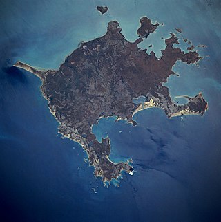
The Anindilyakwa Indigenous Protected Area (IPA) is a region off the coast of Northern mainland Australia, which includes Groote Eylandt, Bickerton Island and other islands in the archipelago, managed by Anindilyakwa people. It is located around 50 km (31 mi) opposite Blue Mud Bay on the eastern coast of Arnhem Land in the Northern Territory, about 630 kilometres (390 mi) from Darwin. It covers an area of approximately 10,000km2.
The Crocodile Islands MaringaIndigenous Protected Area (IPA) is a region inclusive of the 20 islands of the Crocodile Islands archipelago, managed by Millingimbi Outstations Progress Resource Aboriginal Corporation through the Crocodile Islands Rangers. It is located around 440 kilometres east of Darwin covering an area of approximately 8,000 square kilometres.
The DhimurruIndigenous Protected Area (IPA) is a region inclusive around 5,500 square kilometres (2,100 sq mi) of Yolŋu land and sea country in northeast Arnhem Land in the Northern Territory of Australia. It is managed by Dhimurru Aboriginal Corporation through the Dhimurru’s Rangers.
The Katiti-Petermann Indigenous Protected Area (IPA) is a 50,000 km2 (19,000 sq mi) area surrounding Uluru-Kata Tjuta National Park in Central Australia, managed by Anangu Traditional Owners. The region is larger than Switzerland and includes tri-border area of the Northern Territory, Western Australia and South Australia.
The Djelk Indigenous Protected Area (IPA) is a 6,700 km2 (2,600 sq mi) area stretching from central Arnhem Land plateau to the Arafura Sea extending west and east of Maningrida in the Northern Territory of Australia, managed by Bawinanga Rangers.
The GanaIanga-Mindibirrina Indigenous Protected Area (IPA) encompases over 10,000 km2 (3,900 sq mi) of the Waanyi Garawa Aboriginal Land Trust area in the southern Gulf of Carpentariain the Northern Territory of Australia, the traditional lands of the Waanyi and Garawa people. The IPA is managed by them through the Waanyi Garawa and Garawa Ranger groups, administered by the Carpentaria Land Council Aboriginal Corporation.
The Laynhapuy Indigenous Protected Area (IPA) is a 14,728 km2 (5,687 sq mi) area of both land and marine estate located in north-east Arnhem Land in the Northern Territory of Australia, managed by Yolŋu people. The area was extended in 2018.
The Marri-Jabin Indigenous Protected Area (IPA) is a 712 km2 (275 sq mi) area around the Moyle and Little Moyle River area in the Northern Territory of Australia.


