Southwest Head (New Brunswick)

Last updated
Southwest Head SouthwestHeadNB August 2016.jpg
Southwest Head

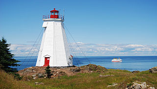
Southern Head is a headland located at the southwestern tip of Grand Manan Island in the Canadian province of New Brunswick.

Both headland and bay are two coastal features that are related and often found on the same coastline. A bay is a body of water—usually seawater and sometimes fresh water— mostly surrounded by land, whereas a headland is surrounded by water on three sides. Headlands are characterized by breaking waves, rocky shores, intense erosion and steep sea cliffs. Bays generally have less wave activity and typically have sandy beaches. Headlands and bays form on discordant coastlines, where the land consists of bands of rock of alternating resistance that run perpendicular to the coast.

Grand Manan Island in New Brunswick, Canada

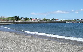
Grand Manan Island is a Canadian island, and the largest of the Fundy Islands in the Bay of Fundy. It is the primary island in the Grand Manan Archipelago, sitting at the boundary between the Bay of Fundy and the Gulf of Maine on the Atlantic coast. Grand Manan is jurisdictionally part of Charlotte County in the province of New Brunswick.

Canada Country in North America

Canada is a country in the northern part of North America. Its ten provinces and three territories extend from the Atlantic to the Pacific and northward into the Arctic Ocean, covering 9.98 million square kilometres, making it the world's second-largest country by total area. Canada's southern border with the United States is the world's longest bi-national land border. Its capital is Ottawa, and its three largest metropolitan areas are Toronto, Montreal, and Vancouver. As a whole, Canada is sparsely populated, the majority of its land area being dominated by forest and tundra. Consequently, its population is highly urbanized, with over 80 percent of its inhabitants concentrated in large and medium-sized cities, many near the southern border. Canada's climate varies widely across its vast area, ranging from arctic weather in the north, to hot summers in the southern regions, with four distinct seasons.

Southern Head is an important landmark:

Bay of Fundy A bay on the east coast of North America between New Brunswick and Nova Scotia

The Bay of Fundy is a bay between the Canadian provinces of New Brunswick and Nova Scotia, with a small portion touching the US state of Maine. It has an extremely high tidal range.

Brier Island island in Canada

Brier Island is an island in the Bay of Fundy in Digby County, Nova Scotia.

Nova Scotia Province of Canada

Nova Scotia is one of Canada's three Maritime Provinces, and one of the four provinces that form Atlantic Canada. Its provincial capital is Halifax. Nova Scotia is the second-smallest of Canada's ten provinces, with an area of 55,284 square kilometres (21,300 sq mi), including Cape Breton and another 3,800 coastal islands. As of 2016, the population was 923,598. Nova Scotia is Canada's second-most-densely populated province, after Prince Edward Island, with 17.4 inhabitants per square kilometre (45/sq mi).

The Canadian Coast Guard maintains an automated light station to assist vessels navigating in the thick fog that frequents the area, particularly during the humid summer months.

Canadian Coast Guard government agency

The Canadian Coast Guard is the coast guard of Canada. Formed in 1962, the coast guard is tasked with marine search and rescue, communication, navigation and transportation issues in Canadian waters, such as navigation aids and icebreaking, marine pollution response and providing support for other Canadian government initiatives. The coast guard operates 119 vessels of varying sizes and 22 helicopters, along with a variety of smaller craft. The Canadian Coast Guard is headquartered in Ottawa, Ontario, and is a Special Operating Agency within Fisheries and Oceans Canada.

Coordinates: 44°35′55″N66°54′20″W / 44.59861°N 66.90556°W / 44.59861; -66.90556

Geographic coordinate system Coordinate system

A geographic coordinate system is a coordinate system that enables every location on Earth to be specified by a set of numbers, letters or symbols. The coordinates are often chosen such that one of the numbers represents a vertical position and two or three of the numbers represent a horizontal position; alternatively, a geographic position may be expressed in a combined three-dimensional Cartesian vector. A common choice of coordinates is latitude, longitude and elevation. To specify a location on a plane requires a map projection.

Related Research Articles

Hudson Strait Strait connecting the Atlantic Ocean to Hudson Bay in Canada

Hudson Strait links the Atlantic Ocean and Labrador Sea to Hudson Bay in Canada. This strait lies between Baffin Island and Nunavik, with its eastern entrance marked by Cape Chidley in Quebec and Resolution Island off Baffin Island. The strait is about 750 km long with an average width of 125 km, varying from 70 km at the eastern entrance to 240 km at Deception Bay.

Davis Strait A northern arm of the Labrador Sea that lies between mid-western Greenland and Nunavut, Canadas Baffin Island

Davis Strait is a northern arm of the Labrador Sea. It lies between mid-western Greenland and Nunavut, Canada's Baffin Island. To the north is Baffin Bay. The strait was named for the English explorer John Davis (1550–1605), who explored the area while seeking a Northwest Passage. By the 1650s it was used for whale hunting.

Machias Seal Island island

Machias Seal Island is an island in disputed water between the Gulf of Maine and the Bay of Fundy, about 16 km (10 mi) southeast from Cutler, Maine, United States and 19 km (12 mi) southwest of Southwest Head, Canada on Grand Manan Island. It is a neighbour to North Rock. Sovereignty of the island is disputed. The Canadian Coast Guard continues to staff a lighthouse on the island; the first lighthouse was constructed there in 1832.

Passamaquoddy Bay inlet of the Bay of Fundy, between the Maine, USA and New Brunswick,Canada

Passamaquoddy Bay is an inlet of the Bay of Fundy, between the U.S. state of Maine and the Canadian province of New Brunswick, at the mouth of the St. Croix River. Most of the bay lies within Canada, with its western shore bounded by Washington County, Maine. The southernmost point is formed by West Quoddy Head on the U.S. mainland in Lubec, Maine; and runs northeasterly through Campobello Island, New Brunswick, engulfing Deer Island, New Brunswick, to the New Brunswick mainland head at L'Etete, New Brunswick in Charlotte County, New Brunswick.

Coastal Transport Limited

Coastal Transport Limited is a ferry company operating in eastern Canada on the Bay of Fundy with headquarters in Saint John, New Brunswick. The company began as a wholly owned subsidiary of Marine Atlantic Incorporated (MAI), and in April 1997 was sold to Murray O. Ryder, the former MAI Vice President of Operations.

Blacks Harbour, New Brunswick Village in New Brunswick, Canada

Blacks Harbour is a Canadian village in Charlotte County, New Brunswick.

White Head Island island in Canada

White Head Island is a Canadian island located in the Bay of Fundy.

New Brunswick Route 776 highway in New Brunswick

Route 776 is a provincial highway in New Brunswick, Canada. It serves as the main road on Charlotte County's Grand Manan Island, following the entire eastern coast of the island.

Anchorage Provincial Park

Anchorage Provincial Park is a public park located on the south-east coast of Grand Manan Island, New Brunswick, Canada. The island, the largest in the Bay of Fundy, is also the primary island in the Grand Manan Archipelago, sitting at the boundary between the Bay of Fundy and the Gulf of Maine.

The Fundy Islands, also known as the Fundy Isles, is a term given to a group of Canadian islands in the Bay of Fundy along the southwestern coast of New Brunswick, Canada, in the provincial county of Charlotte. There are over 25 islands within this group including several parishes including the West Isles. Some of the larger islands are inhabited year-round while some of the smaller islands may have seasonal residents. The largest of the islands is Grand Manan with the second and third largest islands being Campobello Island and Deer Island respectively. Deer Island shares its coastline with not only the Bay of Fundy, but also Passamaquoddy Bay to its north. Smaller island exist along each of the larger islands as well as within Passamaquoddy Bay and along the New Brunswick mainland. Some of these islands include White Head Island, Macs Island and Pendelton Island, Minister's Island and Hospital Island.

North Head, New Brunswick human settlement in Canada

North Head is a community on the island of Grand Manan, New Brunswick. Formerly a separate village, it was amalgamated into the newly formed village of Grand Manan in 1995. North Head is the southern terminus of the Blacks Harbour to Grand Manan Island Ferry.

Seal Cove, New Brunswick human settlement in Canada

Seal Cove is a community on Grand Manan Island, New Brunswick. Formerly a separate village, it was amalgamated into the newly formed village of Grand Manan in 1995.

Campobello Parish, New Brunswick Parish in Canada

Campobello is a Canadian parish including one main island and several small islands and islets in Charlotte County, New Brunswick.

Walton, a three-masted barque, was built for the Parker family in Walton, Nova Scotia in 1855. Under the command of Frederick Parker, brother of ground-breaking Halifax/Dartmouth doctor Daniel McNeill Parker, Walton was painted by notable marine artist Michele Renault in 1857 off Livorno (Leghorn), Italy. The painting currently hangs in a private home in Dartmouth, Nova Scotia. In speaking of his uncle, Captain Frederick, family historian William Frederick Parker notes: "His voyages took him chiefly to the Indian and China seas and the Mediterranean, in the barque 'Walton.' He too, lost his life in following his profession. He was never married. His body was interred at Cardiff, Wales. ".

West Isles Parish, New Brunswick Parish in Canada

West Isles is a Canadian parish including Deer Island and numerous smaller islands in Charlotte County, New Brunswick.

Grand Manan Parish, New Brunswick Parish in Canada

Grand Manan is a Canadian parish created in 1816 from West Isles Parish which includes several islands in Charlotte County, New Brunswick. The islands are part of the Fundy Islands.

Whale Cove is a cove on Grand Manan Island in North Head, New Brunswick, Canada. It is located in the northern part of the island, on the Bay of Fundy, near North Head. The cove's once busy fishing wharf was destroyed in the Groundhog gale of 1976.

The Lord Ashburton was a merchant ship built in 1843 at St. Andrews, New Brunswick. She was wrecked in a nor'easter on Grand Manan Island in January 1857 en route from Toulon to Saint John, New Brunswick.

Swallowtail Lighthouse lighthouse in New Brunswick, Canada

The Swallowtail Lighthouse is a Canadian lighthouse located on Grand Manan Island in the Bay of Fundy. It was the first lighthouse to be built on the island. It was first lit on 7 July 1860 and was automated and de-staffed in 1986.