
The Karakoram is a mountain range in the Kashmir region spanning the border of Pakistan, China, and India, with the northwestern extremity of the range extending to Afghanistan and Tajikistan. Most of the Karakoram mountain range falls under the jurisdiction of Gilgit-Baltistan, which is controlled by Pakistan. Its highest peak, K2, is located in Gilgit-Baltistan, Pakistan. It begins in the Wakhan Corridor (Afghanistan) in the west, encompasses the majority of Gilgit-Baltistan, Pakistan and extends into Ladakh and Aksai Chin. It is part of the larger Trans-Himalayan mountain ranges.

Hispar Muztagh is a sub-range of the Karakoram mountain range. It is located in the Nagar District of Gilgit-Baltistan, Pakistan, north of Hispar Glacier, south of Shimshal Valley, and east of the Hunza Valley. It is the second highest sub-range of the Karakoram, the highest being the Baltoro Muztagh. The highest mountain in the range is Distaghil Sar (7,885m/25,869 ft).

Kunyang Chhish is the second-highest mountain in the Hispar Muztagh, a subrange in the Karakoram mountains in Pakistan. An alternate variations of the name are Kunyang Kish and Khinyang Chhish. Its height, also sometimes given as 7,823 metres (25,666 ft), is ranked 21st in the world.

Malubiting, also known as Malubiting West, ranks as the second highest peak between Haramosh and Hisper valley in the Karakoram range in Pakistan. It is situated between Bilchar Dobani and Haramosh Peak, in the Gilgit-Baltistan region.
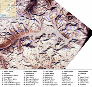
The Baltoro Muztagh is a subrange within the Karakoram mountain range. It spans across the Baltistan region of Gilgit-Baltistan, which is the northernmost political entity of Pakistan, and extends into Xinjiang, China. The crest of this range also serves as part of the border between Pakistan and China.

The Rakaposhi-Haramosh Mountains are a subrange of the Karakoram range. They are located in the Bagrot Valley in the Gilgit and Nagar districts of the Gilgit-Baltistan region, Pakistan.
The Panmah Muztagh is a subrange of the Karakoram range, in Shigar, a district of Gilgit-Baltistan, Pakistan.
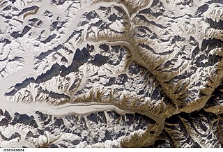
Hispar Glacier is a 49-km (30-mile) long glacier situated in the Karakoram Mountains of Gilgit–Baltistan, Pakistan. It converges with the Biafo Glacier, which extends for 67 kilometers, at the Hispar La (Pass), reaching an altitude of 5,128 meters. This confluence creates the world's longest glacial system outside of the polar regions.

The Saltoro Mountains form a subrange within the Karakoram Range and are situated in the southeastern part of the Karakoram. They lie on the southwest side of the Siachen Glacier, which is one of the two longest glaciers in the world outside the polar regions. The name "Saltoro" is also associated with the Saltoro Valley, located west of this range and descending on the Pakistani side of the Saltoro Range, which generally follows the Actual Ground Position Line (AGPL).

The Saser Muztagh is the easternmost subrange of the Karakoram range, in the Ladakh region of India. It is bounded on the south, east and northeast by the Shyok River, which bends sharply around the southeast corner of the range. On the west it is separated from the neighboring Kailas Mountains by the Nubra River, while the Sasser Pass marks the boundary between this range and the Rimo Muztagh to the north. The Ladakh Range stands to the south of the Saser Muztagh, across the Shyok River.

Trivor is one of the high mountain peaks of the Hispar Muztagh, a subrange of the Karakoram range in the Shimshal Valley, Gilgit-Baltistan of Pakistan. Its height is often given as 7,728 metres (25,354 ft), but this elevation is not consistent with photographic evidence. The height given here is from a Russian 1:100,000 topographic map.

Gilgit-Baltistan is an administrative territory of Pakistan in the northern part of the country. It was given self-governing status on August 29, 2009. Gilgit-Baltistan comprises 14 districts within three divisions. The four districts of Skardu Kharmang Shigar and Ghanche are in the Baltistan Division, four districts of Gilgit Ghizer Hunza and Nagar districts which were carved out of Gilgit District are in the Gilgit Division and the third division is Diamir, comprising Chilas and Astore. The main political centres are the towns of Gilgit and Skardu.
The South Ghujerab Mountains are a subrange of the Karakoram range in the Northern Areas of Pakistan. The highest peak in the range is Karun Koh, 7,164 m (23,503 ft). This is the only 7,000 metre peak in the range
Spantik, or Golden Peak, is a mountain situated in the subrange within the Karakoram range. It is located in the Arandu Valley, Shigar District, within the Gilgit-Baltistan region of Pakistan. The northwest face of Spantik is dominated by a pronounced pillar of creamy yellow marble which reaches up its north face to 300 m below the summit. Its distinctive appearance has given the peak its Buruskaski name, "Ganesh Chish" or Golden Peak. This outcropping is renowned for its exceptionally challenging climbing route, famously referred to as the "Golden Pillar."
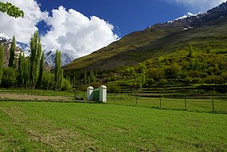
The Hopper Valley, also spelled Hopar Valley, is a section of the Nagar Valley in Gilgit-Baltistan, Pakistan. It is situated approximately 10 km from Nagar Khas, the main city of the Nagar Valley. Hopper Valley is known for the Spantik and Hopper glaciers.

The Braldu River flows in the Shigar District of Gilgit Baltistan in Pakistan. The Braldu River joins the Basha Basna River, and together they form the Shigar River, which is a tributary of the Indus River.
Paraber Peak is a peak in Stak Valley of Gilgit-Baltistan. This mountain is located in the Karakoram range and the prominent landmarks in the vicinity are Haramosh Peak, Laila Peak, Kutia Lungma Glacier and the Chogo Lungma Glacier.


