Sparrowhawk Hill

Last updated
Map of Little Cayman showing Sparrowhawk Hill in the centre of the island LittleCayman.JPG
Map of Little Cayman showing Sparrowhawk Hill in the centre of the island
Flowers of Canella winterana, found on Sparrowhawk Hill Canella winterana Guadeloupe.JPG
Flowers of Canella winterana, found on Sparrowhawk Hill

Sparrowhawk Hill lies in the centre of Little Cayman, one of the Cayman Islands, a British Overseas Territory in the Caribbean Sea. It is one of the territory’s Important Bird Areas (IBAs).

Little Cayman island

Little Cayman is one of three islands comprising the Cayman Islands. It is located in the Caribbean Sea, approximately 60 miles northeast of Grand Cayman and five miles (8 km) west of Cayman Brac. Little Cayman is by far the least populous, with a permanent population of about 170. It is about 10 miles (16 km) long with an average width of 1 mile (2 km) and most of the island is undeveloped. Almost the entire island is at sea level. The highest elevation is about 40 feet.

Cayman Islands British Overseas Territory in the Caribbean

The Cayman Islands is an autonomous British Overseas Territory in the western Caribbean Sea. The 264-square-kilometre (102-square-mile) territory comprises the three islands of Grand Cayman, Cayman Brac and Little Cayman, which are located to the south of Cuba and northeast of Honduras, between Jamaica and the Yucatán Peninsula. As of July 2018, the total population of the Cayman Islands is estimated to be 59,613, making it the second-most populated British overseas territory after Bermuda. The capital city is George Town, situated on Grand Cayman, by far the most populous of the three islands.

British Overseas Territories territory under the jurisdiction and sovereignty of the United Kingdom but not part of it

The British Overseas Territories (BOTs) or United Kingdom Overseas Territories (UKOTs) are 14 territories under the jurisdiction and sovereignty of the United Kingdom. They are remnants of the British Empire that have not been granted independence or have voted to remain British territories. These territories do not form part of the United Kingdom and, with the exception of Gibraltar, are not part of the European Union. Most of the permanently inhabited territories are internally self-governing, with the UK retaining responsibility for defence and foreign relations. Three are inhabited only by a transitory population of military or scientific personnel. They all share the British monarch as head of state.

Contents

Description

Sparrowhawk Hill is a 255 ha tract of pristine native dry forest with a maximum elevation of 20 m above sea level. Dominant tree species are Calyptranthes pallens , Canella winterana , Chionanthus caymanensis , Dipholis salicifolia and Erythroxylum areolatum . [1]

Tropical and subtropical dry broadleaf forests biome

The tropical and subtropical dry broadleaf forest is a habitat type defined by the World Wide Fund for Nature and is located at tropical and subtropical latitudes. Though these forests occur in climates that are warm year-round, and may receive several hundred centimeters of rain per year, they have long dry seasons which last several months and vary with geographic location. These seasonal droughts have great impact on all living things in the forest.

Birds

The IBA was identified as such by BirdLife International because it supports significant populations of white-crowned pigeons, Caribbean elaenias and vitelline warblers. [1]

BirdLife International is a global partnership of conservation organisations that strives to conserve birds, their habitats, and global biodiversity, working with people towards sustainability in the use of natural resources. It is the world's largest partnership of conservation organisations, with over 120 partner organisations.

White-crowned pigeon species of bird

The white-crowned pigeon is a species of bird in the family Columbidae. It inhabits the northern and central Caribbean islands and some places on the North and Central American mainland. John James Audubon painted the pigeons, including the watercolour in his work Birds of America, published in the early 19th century.

Caribbean elaenia species of bird

The Caribbean elaenia is a species of bird in the family Tyrannidae found in the West Indies and parts of Central America. Its natural habitats are tropical and subtropical dry broadleaf forest, subtropical or tropical moist lowland forest, and heavily degraded former forest.

Related Research Articles

The Bluff (Cayman Islands) mountain in the Cayman Islands


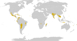
The Bluff is the highest part of the Cayman Islands, a British Overseas Territory in the Caribbean Sea. It stands at the eastern end of the island of Cayman Brac and has a maximum elevation of 43 m (141 ft).

Booby Pond Nature Reserve

Booby Pond Nature Reserve is a protected wetland on Little Cayman, one of the Cayman Islands, a British Overseas Territory in the Caribbean Sea.

Botanic Park and Salina Reserve Important Bird Area

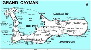
The Botanic Park and Salina Reserve Important Bird Area comprises two separate sites on Grand Cayman, one of the Cayman Islands, a British Overseas Territory in the Caribbean Sea.

Central Mangrove Wetland

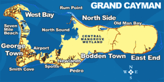
The Central Manrove Wetland is a large area of mangrove dominated wetland on Grand Cayman, one of the Cayman Islands, a British Overseas Territory in the Caribbean Sea. It is one of the territory’s Important Bird Areas (IBAs).

Crown Wetlands

The Crown Wetlands lie on Little Cayman, one of the Cayman Islands, a British Overseas Territory in the Caribbean Sea. Collectively they form one of the territory’s Important Bird Areas (IBAs).

Eastern Dry Forest

The Eastern Dry Forest lies at the eastern end of Grand Cayman, one of the Cayman Islands, a British Overseas Territory in the Caribbean Sea. It is one of the territory’s Important Bird Areas (IBAs).

Frank Sound Forest

Frank Sound Forest lies near the southern coast of the East End distinct of Grand Cayman, one of the Cayman Islands, a British Overseas Territory in the Caribbean Sea. It is one of the territory’s Important Bird Areas (IBAs).

Franklins Forest

Franklin's Forest lies near the centre of the East End distinct of Grand Cayman, one of the Cayman Islands, a British Overseas Territory in the Caribbean Sea. It is one of the territory’s Important Bird Areas (IBAs).

Mastic Reserve

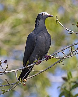
Mastic Reserve lies at the eastern end of the North Side of Grand Cayman, one of the Cayman Islands, a British Overseas Territory in the Caribbean Sea. It, with the associated Mastic Trail, is managed by the National Trust for the Cayman Islands and is one of the territory's Important Bird Areas (IBAs). It is named after the yellow mastic and black mastic trees which occur in the reserve.

Road Salt Pond

Road Salt Pond, also known as Road Bay Pond or simply Road Pond, is a wetland in Anguilla, a British Overseas Territory in the Caribbean Sea. It is one of the territory’s Important Bird Areas (IBAs).

Cauls Pond

Cauls Pond is a wetland in Anguilla, a British Overseas Territory in the Caribbean Sea. It is one of the territory’s Important Bird Areas (IBAs).

West End Pond

West End Pond is a wetland in Anguilla, a British Overseas Territory in the Caribbean Sea. It is one of the territory’s Important Bird Areas (IBAs).

Rendezvous Bay Pond

Rendezvous Bay Pond, also known as Rendezvous Bay Salt Pond, is a wetland in Anguilla, a British Overseas Territory in the Caribbean Sea. It is one of the territory’s Important Bird Areas (IBAs).

Meads Bay Pond

Meads Bay Pond is a wetland in Anguilla, a British Overseas Territory in the Caribbean Sea. It is one of the territory’s Important Bird Areas (IBAs).

Merrywing Pond System

The Merrywing Pond System is a golf course wetland system in Anguilla, a British Overseas Territory in the Caribbean Sea. It forms one of the territory’s Important Bird Areas (IBAs).

Forest Bay Pond

Forest Bay Pond is a small wetland in Anguilla, a British Overseas Territory in the Caribbean Sea. It forms one of the territory’s Important Bird Areas (IBAs).

Northern Forested Ghauts

The Northern Forested Ghauts constitute a tract of land on the island of Montserrat, a British Overseas Territory in the Leeward Islands of the Caribbean Sea. It forms one of the territory’s Important Bird Areas (IBAs).

Centre Hills hill in Montserrat

Centre Hills is a forest reserve on the island of Montserrat, a British Overseas Territory in the Leeward Islands of the Caribbean Sea. It forms one of the territory’s Important Bird Areas (IBAs), which encompasses the forest reserve as well as additional habitat for the Montserrat oriole, the territory’s endemic, and critically endangered, national bird.

South Soufriere Hills

South Soufriere Hills is a 35 ha patch of forest on the island of Montserrat, a British Overseas Territory in the Leeward Islands of the Caribbean Sea. It forms one of the territory’s Important Bird Areas (IBAs).

Wades Green and Teren Hill Important Bird Area

The Wades Green and Teren Hill Important Bird Area is a 226 ha tract of land on the island of North Caicos in the Turks and Caicos Islands, a British Overseas Territory in the Lucayan Archipelago of the western Atlantic Ocean. It forms one of the territory’s Important Bird Areas (IBAs).

References

  1. 1 2 "Sparrowhawk Hill". Important Bird Areas factsheet. BirdLife International. 2014. Retrieved 2014-04-06.

Coordinates: 19°41′00″N80°02′00″W / 19.68333°N 80.03333°W / 19.68333; -80.03333

Geographic coordinate system Coordinate system

A geographic coordinate system is a coordinate system that enables every location on Earth to be specified by a set of numbers, letters or symbols. The coordinates are often chosen such that one of the numbers represents a vertical position and two or three of the numbers represent a horizontal position; alternatively, a geographic position may be expressed in a combined three-dimensional Cartesian vector. A common choice of coordinates is latitude, longitude and elevation. To specify a location on a plane requires a map projection.