
Hertfordshire is a ceremonial county in the East of England and one of the home counties. It borders Bedfordshire to the north-west, Cambridgeshire to the north-east, Essex to the east, Greater London to the south and Buckinghamshire to the west. The largest settlement is Watford, and the county town is Hertford.

Berkhamsted is a historic market town in Hertfordshire, England, in the Bulbourne valley, 26 miles (42 km) north-west of London. The town is a civil parish with a town council within the borough of Dacorum which is based in the neighbouring large new town of Hemel Hempstead. Berkhamsted, along with the adjoining village of Northchurch, is encircled by countryside, much of it in the Chiltern Hills which is an Area of Outstanding Natural Beauty (AONB).

The London and Birmingham Railway (L&BR) was a railway company in the United Kingdom, in operation from 1833 to 1846, when it became part of the London and North Western Railway (L&NWR).

The A41 is a trunk road between London and Liverpool, England. Now in parts replaced by motorways, it passes through or near Watford, Kings Langley, Hemel Hempstead, Aylesbury, Bicester, Solihull, Birmingham, West Bromwich, Wolverhampton, Newport, Whitchurch, Chester and Ellesmere Port.
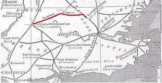
Akeman Street is a Roman road in southern England between the modern counties of Hertfordshire and Gloucestershire. It is approximately 117 kilometres (73 mi) long and runs roughly east–west.

Hemel Hempstead is a town in the Dacorum district in Hertfordshire, England. It is located 24 miles (39 km) north-west of London; nearby towns include Watford, St Albans and Berkhamsted. The population at the 2021 census was 95,961.

Dagnall is a village in the parish of Edlesborough, in Buckinghamshire, England.

Dacorum is a local government district with borough status in Hertfordshire, England. The council is based in Hemel Hempstead. The borough also includes the towns of Berkhamsted and Tring and surrounding villages. The borough had a population of 155,081 in 2021. Dacorum was created in 1974 and is named after the ancient hundred of Dacorum which had covered a similar area. The borough of Dacorum is the westernmost of Hertfordshire's ten districts. It borders St Albans, Three Rivers, Buckinghamshire and Central Bedfordshire.
BBC Three Counties Radio is the BBC's local radio station serving the counties of Bedfordshire, Hertfordshire and Buckinghamshire.
The Grand Junction Canal is a canal in England from Braunston in Northamptonshire to the River Thames at Brentford, with a number of branches. The mainline was built between 1793 and 1805, to improve the route from the Midlands to London, by-passing the upper reaches of the River Thames near Oxford, thus shortening the journey.

Hemel Hempstead is a constituency in Hertfordshire represented in the House of Commons of the Parliament of the United Kingdom. It elects one Member of Parliament (MP) by the first-past-the-post system. Since 2024, it has been represented by David Taylor of the Labour Party.

South West Hertfordshire is a constituency in the House of Commons of the UK Parliament, represented since 2019 by Gagan Mohindra, a Conservative.

Hemel Hempstead railway station lies in Boxmoor, on the western edge of the town of Hemel Hempstead, Hertfordshire, England. It is located 24+1⁄2 miles (39.4 km) north-west of London Euston on the West Coast Main Line. The station is managed by London Northwestern Railway, who operate its train services along with Southern.

Berkhamsted railway station is in the historic market town of Berkhamsted, Hertfordshire, England. It is located just beside Berkhamsted Castle, overlooking the Grand Junction Canal. The station is 28 miles (45 km) north west of London Euston on the West Coast Main Line. London Northwestern Railway operates services to London, Northampton and many other destinations.

Tring railway station is 1.5 miles (2.4 km) outside the market town of Tring, close to the Grand Union Canal but actually nearer to the village of Aldbury in Hertfordshire, England. Situated on the West Coast Main Line, the station is now an important marshalling point for commuter trains from here for most stations to London Euston.

The River Bulbourne is a small river in Dacorum, Hertfordshire, England. The word bourne derives from the Anglo-Saxon word for a stream. It is an unnavigable tributary of the River Gade, which flows into the River Colne, which in turn is a tributary of the River Thames. The Bulbourne is an example of a chalk stream, which is a watercourse that flows from chalk-fed groundwater. Chalk streams are a very rare habitat globally, with more than 85% of all the 210 chalk streams in the world are found in England. The river is reduced in size, due to human activity, the main one being the building of the London to Birmingham Grand Union Canal through the narrow valley which takes most of the river's water.

Boxmoor is part of Hemel Hempstead in Hertfordshire. It is within the district of Dacorum and comprises mainly 19th-century housing and meadowland, with transport links from London to the Midlands. At the 2011 Census, the population of Boxmoor was included in the Dacorum ward of Bovingdon, Flaunden and Chipperfield.

Turnpike trusts were bodies set up by individual acts of Parliament, with powers to collect road tolls for maintaining the principal roads in Britain from the 17th but especially during the 18th and 19th centuries. At the peak, in the 1830s, over 1,000 trusts administered around 30,000 miles (48,000 km) of turnpike road in England and Wales, taking tolls at almost 8,000 toll-gates and side-bars.

Cow Roast is a hamlet within the civil parishes of Northchurch and Wigginton in Hertfordshire, England. It is between Tring and Berkhamsted, along the A4251, adjacent to the Grand Union Canal and the West Coast Main Line. Today it comprises a row of 20th-century houses and a marina, together with several older properties including a restaurant. There are three car dealerships and a petrol station beside the main road.


